File:Extent of Western Roman Empire 395.png
Here nagîvasyonê
Here lêgerînê
Versyonekî jê mezintir tune.
Extent_of_Western_Roman_Empire_395.png (493 × 548 pixel, mezinbûnê data: 40 KB, MIME-typ: image/png)
Captions
Captions
Add a one-line explanation of what this file represents

|
This historical map image could be re-created using vector graphics as an SVG file. This has several advantages; see Commons:Media for cleanup for more information. If an SVG form of this image is available, please upload it and afterwards replace this template with
{{vector version available|new image name}}.
It is recommended to name the SVG file “Extent of Western Roman Empire 395.svg”—then the template Vector version available (or Vva) does not need the new image name parameter. |
Danasîn[biguhêre]
| Danasîn |
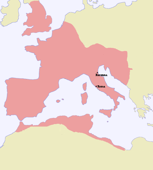
Español: Extensión del Imperio romano de occidente en 395.dC, a la muerte de Teodosio I. |
| Dîrok | |
| Çavkanî | |
| Xwedî |
Lîsans[biguhêre]
| I, the copyright holder of this work, release this work into the public domain. This applies worldwide. In some countries this may not be legally possible; if so: I grant anyone the right to use this work for any purpose, without any conditions, unless such conditions are required by law. |
Dîroka daneyê
Ji bo dîtina guhartoya wê demê bişkoka dîrokê bitikîne.
| Dîrok/Katjimêr | Wêneyê biçûk | Mezinahî | Bikarhêner | Şirove | |
|---|---|---|---|---|---|
| niha | 21:19, 7 sibat 2006 | | 493 x 548 (40 KB) | Tokle (gotûbêj | beşdarî) |
Tu nikarî cardin li ser vê dosyeyê binivîsînî.
Bikaranîna pelê
Ev 18 rûpel li jêr vê dosyeyê bi kar tînin:
- Atlas of Algeria
- Atlas of Austria
- Atlas of Belgium
- Atlas of European history
- Atlas of France
- Atlas of Galicia
- Atlas of Germany
- Atlas of Italy
- Atlas of Luxembourg
- Atlas of Malta
- Atlas of Morocco
- Atlas of Portugal
- Atlas of Spain
- Atlas of Tunisia
- Atlas of ancient Rome
- Atlas of the Netherlands
- Atlas of the United Kingdom
- Maps of Switzerland
Bikaranîna gerdûnî ya pelê
Ev wîkiyên di rêzê de vê pelê bi kar tînin:
- Bikaranîna di af.wikipedia.org de
- Bikaranîna di als.wikipedia.org de
- Bikaranîna di bg.wikipedia.org de
- Bikaranîna di bs.wikipedia.org de
- Bikaranîna di cs.wikipedia.org de
- Bikaranîna di de.wikipedia.org de
- Bikaranîna di en.wikipedia.org de
- Bikaranîna di eo.wikipedia.org de
- Bikaranîna di es.wikipedia.org de
- Bikaranîna di is.wikipedia.org de
- Bikaranîna di pl.wikipedia.org de
- Bikaranîna di sh.wikipedia.org de
- Bikaranîna di sk.wikipedia.org de
- Bikaranîna di sr.wikipedia.org de
- Bikaranîna di sw.wikipedia.org de