File:Fort Hall Location Map Text.svg
Jump to navigation
Jump to search

Size of this PNG preview of this SVG file: 512 × 216 pixels. Other resolutions: 320 × 135 pixels | 640 × 270 pixels | 1,024 × 432 pixels | 1,280 × 540 pixels | 2,560 × 1,080 pixels.
Original file (SVG file, nominally 512 × 216 pixels, file size: 382 KB)
Captions
Captions
Add a one-line explanation of what this file represents
Summary
[edit]| Description |
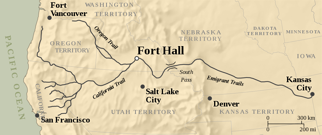
English: Map of the location of Fort Hall in the United States of America, with state and territory borders of 1860 and routes of the California and Oregon Emigrant Trails. |
|||
| Date | ||||
| Source |
Own work based on: Fort Hall Location Map.svg
|
|||
| Author | Tentotwo; Johannes Kalliauer | |||
| Permission (Reusing this file) |
Fort Hall Location Map.svg | |||
| SVG development | This W3C-invalid world map was created with an unknown SVG tool.
|
|||
| Projection | Lambert Conformal Conic, central longitude 110° W, normal latitudes 40° N and 45° N. E-W extents -1420766:1414233, N-S extents 4508096:5701780 |


| Camera location | | View this and other nearby images on: OpenStreetMap |
|---|
Licensing
[edit]
I, the copyright holder of this work, hereby publish it under the following license:
This file is licensed under the Creative Commons Attribution-Share Alike 4.0 International license.
- You are free:
- to share – to copy, distribute and transmit the work
- to remix – to adapt the work
- Under the following conditions:
- attribution – You must give appropriate credit, provide a link to the license, and indicate if changes were made. You may do so in any reasonable manner, but not in any way that suggests the licensor endorses you or your use.
- share alike – If you remix, transform, or build upon the material, you must distribute your contributions under the same or compatible license as the original.
File history
Click on a date/time to view the file as it appeared at that time.
| Date/Time | Thumbnail | Dimensions | User | Comment | |
|---|---|---|---|---|---|
| current | 18:17, 11 December 2017 | | 512 × 216 (382 KB) | JoKalliauer (talk | contribs) |
You cannot overwrite this file.
File usage on Commons
The following 7 pages use this file:
File usage on other wikis
The following other wikis use this file:
- Usage on de.wikipedia.org
- Usage on en.wikipedia.org
- Usage on nl.wikipedia.org