File:Freedom of Panorama in Europe.svg
Aller à la navigation
Aller à la recherche

Taille de cet aperçu PNG pour ce fichier SVG : 713 × 599 pixels. Autres résolutions : 286 × 240 pixels | 571 × 480 pixels | 914 × 768 pixels | 1 218 × 1 024 pixels | 2 437 × 2 048 pixels | 828 × 696 pixels.
Fichier d’origine (Fichier SVG, nominalement de 828 × 696 pixels, taille : 700 kio)
Légendes
Légendes
Ajoutez en une ligne la description de ce que représente ce fichier
Description
| Description |
Deutsch: Übersichtskarte über den Geltungsbereich der Panoramafreiheit in den Ländern Europas (aus dem für Wikimedia Commons relevanten Standpunkt).
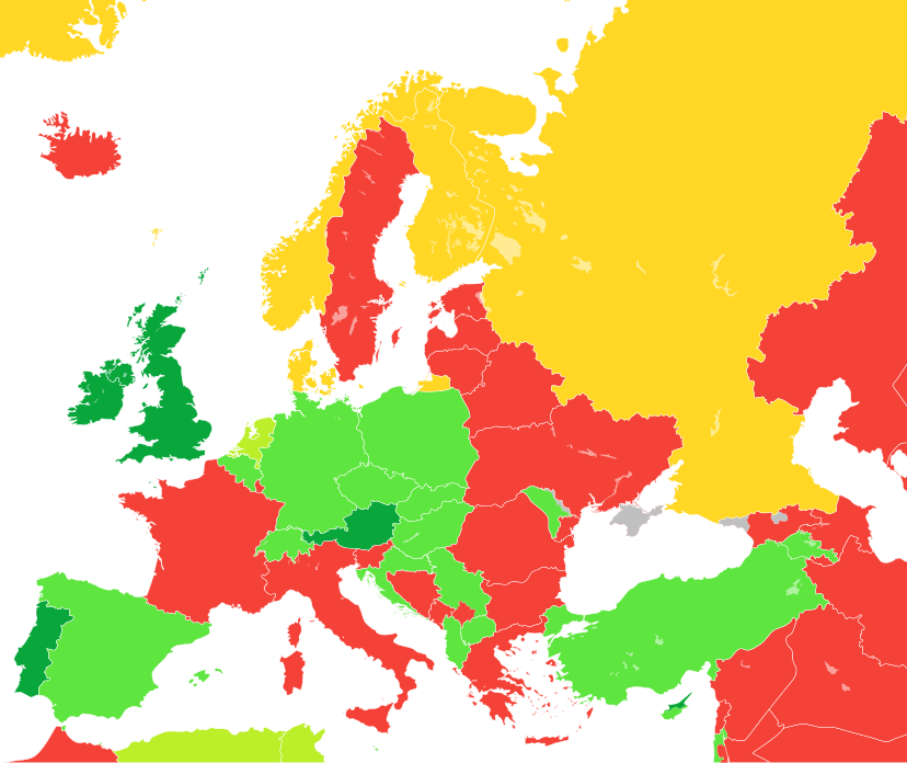
English: A map showing the level of Freedom of Panorama (as seen from the Wikimedia Commons standpoint) in the countries of Europe as well as parts of Western Asia and North Africa
Español: Mapa que ilustra las categorías de la libertad de panorama (desde la perpectiva de Wikimedia Commons) en los países europeos.
Français : Carte montrant le niveau liberté de Panorama (du point de vue de Wikimedia Commons) dans les pays d'Europe.
Italiano: Mappa che illustra la situazione della c.d. libertà di panorama (dal punto di vista di Wikimedia Commons) nei Paesi europei.
日本語: ヨーロッパ諸国の風景の自由 (英語版) (ウィキメディア・コモンズの見解による) の程度。
Nederlands: Kaart tonende het niveau van de panoramavrijheid (vanuit het Wikimedia Commons oogpunt) van de Europese landen.
Tagalog: Isang mapa na nagpapakita ng mga antas ng kalayaan sa panorama (sang-ayon sa pananaw ng Wikimedia Commons) sa mga bansang Europeo.
中文:一張地圖,顯示了歐洲國家的全景自由(從維基共享資源的角度來看)。
NL: Public interiors are OK, but schools, opera buildings, entrance halls of businesses, and museums are not public places for the purpose of Dutch law, while railway stations are.
OK, dont aussi les intérieurs publics
OK
OK pour bâtiments seulement
Non
Inconnu (seuls Andorre, San Marin, Monaco, la Crimée et la Suède sont notés comme "inconnu") |
| Date | / 20 avril 2010, 16:49 (UTC) (date de téléversement originale) |
| Source |
Ce fichier est dérivé de : Blank map of Europe cropped.svg |
| Auteur |
|
| Autres versions |
|
| SVG information |
.png)
.svg)


.svg)
Conditions d’utilisation
Moi, en tant que détenteur des droits d’auteur sur cette œuvre, je la publie sous la licence suivante :
Ce fichier est disponible selon les termes de la licence Creative Commons Attribution – Partage dans les Mêmes Conditions 3.0 (non transposée).
- Vous êtes libre :
- de partager – de copier, distribuer et transmettre cette œuvre
- d’adapter – de modifier cette œuvre
- Sous les conditions suivantes :
- paternité – Vous devez donner les informations appropriées concernant l'auteur, fournir un lien vers la licence et indiquer si des modifications ont été faites. Vous pouvez faire cela par tout moyen raisonnable, mais en aucune façon suggérant que l’auteur vous soutient ou approuve l’utilisation que vous en faites.
- partage à l’identique – Si vous modifiez, transformez, ou vous basez sur cette œuvre, vous devez distribuer votre contribution sous la même licence ou une licence compatible avec celle de l’original.
Journal des téléversements d’origine
This image is a derivative work of the following images:
- File:Blank map of Europe cropped.svg licensed with Cc-by-sa-2.5
- 2010-04-20T15:38:55Z Quibik 645x690 (266750 Bytes) Serbia had a wrong ISO code.
- 2010-04-20T14:50:17Z Quibik 645x690 (266733 Bytes) RSVG's rendering failed, trying to fix
- 2010-04-20T14:45:48Z Quibik 645x690 (264475 Bytes) further cleanup
- 2009-04-30T19:51:36Z Insuranze 645x690 (269667 Bytes) code cleanup
- 2007-06-07T22:58:16Z Revolus 645x690 (540660 Bytes) {{Information | Description=Cropped version of [[:Image:Blank map of Europe.svg|Blank map of Europe.svg]] as descriped by its author. {{en|A blank Map of Europe in SVG format. Every country has an id which is its ISO-3116-1-
Téléversé avec derivativeFX
Historique du fichier
Cliquer sur une date et heure pour voir le fichier tel qu'il était à ce moment-là.
| Date et heure | Vignette | Dimensions | Utilisateur | Commentaire | |
|---|---|---|---|---|---|
| actuel | 4 mai 2024 à 18:45 | | 828 × 696 (700 kio) | ToprakM (d | contributions) | updated Northern Cyprus |
| 21 octobre 2023 à 15:51 |  | 828 × 696 (700 kio) | Golden (d | contributions) | update Artsakh | |
| 13 février 2023 à 17:15 |  | 828 × 696 (704 kio) | TilmannR (d | contributions) | Reverted to previous version. Major changes should be discussed and more carefully planned. | |
| 13 février 2023 à 15:28 |  | 828 × 696 (716 kio) | Amitchell125 (d | contributions) | colours replaced to suit people who are colour-blind | |
| 17 avril 2022 à 15:38 |  | 828 × 696 (704 kio) | Saippuakauppias (d | contributions) | Crimea grey, cf. Discussion | |
| 26 octobre 2021 à 10:12 |  | 828 × 696 (704 kio) | Brateevsky (d | contributions) | Smaller map with Kazakhstan and Caucasus states | |
| 26 octobre 2021 à 06:44 |  | 1 078 × 697 (704 kio) | Brateevsky (d | contributions) | Reverted to version as of 07:03, 4 September 2021 (UTC): Kazakhstan and Azerbaijan are European countries | |
| 9 octobre 2021 à 09:40 |  | 593 × 606 (704 kio) | Chubit (d | contributions) | ... | |
| 4 septembre 2021 à 07:03 |  | 1 078 × 697 (704 kio) | Chubit (d | contributions) | Algeria and Tunisia to grass green | |
| 25 août 2021 à 05:02 |  | 593 × 606 (704 kio) | Chubit (d | contributions) | Adjust the border |
Vous ne pouvez pas remplacer ce fichier.
Utilisations locales du fichier
Les 53 pages suivantes utilisent ce fichier :
- User:Chumwa/OgreBot/Potential transport maps/2016 April 1-10
- User:Elisardojm
- User:Fulvio314/commons gallery
- User:Jacopo Werther
- User talk:Cezarika1/Archive 1
- User talk:Strakhov
- Commons:Café/Archivo/02-2019
- Commons:Deletion requests/Archive/2011/08/31
- Commons:Deletion requests/Archive/2019/10/31
- Commons:Deletion requests/File:Luxembourg-Steinfort-sculpture human being-02ASD.jpg
- Commons:Deletion requests/File:Portoroz,-Palace-Hotel-(270711).jpg
- Commons:Freedom of panorama
- Commons:Freedom of panorama/ar
- Commons:Freedom of panorama/be-tarask
- Commons:Freedom of panorama/bn
- Commons:Freedom of panorama/ca
- Commons:Freedom of panorama/cs
- Commons:Freedom of panorama/de
- Commons:Freedom of panorama/en
- Commons:Freedom of panorama/eo
- Commons:Freedom of panorama/es
- Commons:Freedom of panorama/et
- Commons:Freedom of panorama/fa
- Commons:Freedom of panorama/fr
- Commons:Freedom of panorama/he
- Commons:Freedom of panorama/hu
- Commons:Freedom of panorama/id
- Commons:Freedom of panorama/it
- Commons:Freedom of panorama/ja
- Commons:Freedom of panorama/ko
- Commons:Freedom of panorama/mk
- Commons:Freedom of panorama/pl
- Commons:Freedom of panorama/pt
- Commons:Freedom of panorama/ru
- Commons:Freedom of panorama/sr
- Commons:Freedom of panorama/sv
- Commons:Freedom of panorama/ta
- Commons:Freedom of panorama/uk
- Commons:Freedom of panorama/uz
- Commons:Freedom of panorama/vi
- Commons:Freedom of panorama/zh
- Commons:Graphic Lab/Map workshop/Archive/2014
- Commons:Libbirtà di panurama
- Commons:井戸端/過去ログ10
- File:Freedom of Panorama in Europe.svg
- File:Freedom of Panorama in Europe 1.svg
- File:Freedom of Panorama in Europe NC.svg
- File:Levels of Freedom of Panorama in Europe.svg
- File:Levels of Freedom of Panorama in Europe (legend).svg
- File:Levels of Freedom of Panorama of Europe (large).svg
- File:Panoramafreiheit in Europa (Karte).png
- Template:Map-FoP-Europe
- Template:Map-FoP-internal links-Europe
.jpg)
Utilisations du fichier sur d’autres wikis
Les autres wikis suivants utilisent ce fichier :
- Utilisation sur az.wikipedia.org
- Utilisation sur ca.wikipedia.org
- Utilisation sur de.wikipedia.org
- Utilisation sur de.wikivoyage.org
- Utilisation sur dk.wikimedia.org
- Utilisation sur en.wikipedia.org
- Utilisation sur eo.wikipedia.org
- Utilisation sur es.wikipedia.org
- Utilisation sur ee.wikimedia.org
- Utilisation sur fa.wikipedia.org
- Utilisation sur fr.wikipedia.org
- Utilisation sur ga.wikipedia.org
- Utilisation sur gl.wikipedia.org
- Utilisation sur he.wikipedia.org
- Utilisation sur hr.wikipedia.org
- Utilisation sur ja.wikipedia.org
Voir davantage sur l’utilisation globale de ce fichier.