File:Germany general map.png
跳转到导航
跳转到搜索
本预览的尺寸:471 × 599像素。 其他分辨率:189 × 240像素 | 377 × 480像素 | 603 × 768像素 | 805 × 1,024像素 | 1,979 × 2,518像素。
原始文件 (1,979 × 2,518像素,文件大小:7 MB,MIME类型:image/png)
说明
说明
添加一行文字以描述该文件所表现的内容
|
摘要
[编辑]| 描述 |
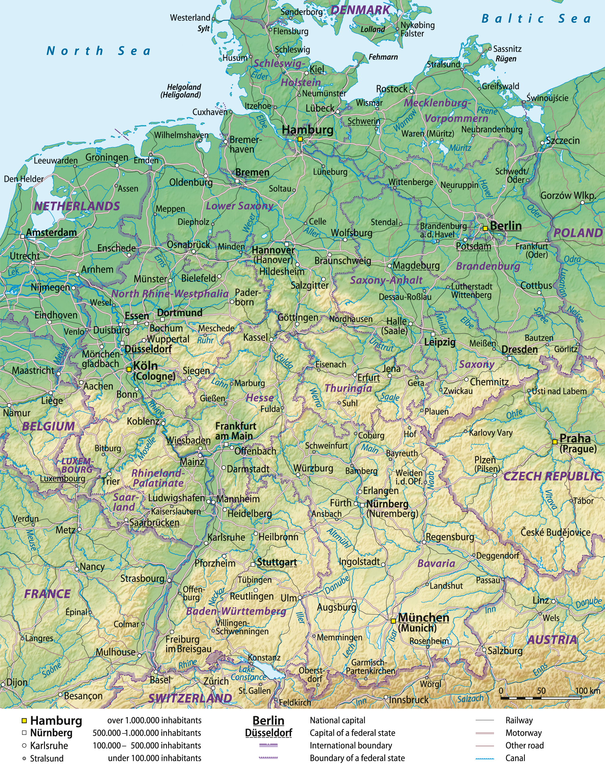
Deutsch: Übersichtskarte von Deutschland, englische Version
English: General map of Germany, English version
Français : Carte générale de l'Allemagne, en anglais |
||
| 日期 | 08-06-2008 | ||
| 来源 |
Self made, using Generic Mapping Tools (source code below), based on United States National Imagery and Mapping Agency data.
|
||
| 作者 | Lencer and NordNordWest | ||
| 授权 (二次使用本文件) |
我,本作品著作权人,特此采用以下许可协议发表本作品:
本文件采用知识共享署名-相同方式共享 3.0 未本地化版本许可协议授权。
您可以选择您需要的许可协议。 |
||
| 其他版本 |


Source code
[编辑]
- color_table based of fr:Aide:Cartographie:
# ih_land_de.cpt
   0 148 191 139    200 189 204 150
 200 189 204 150    500 239 235 192
 500 239 235 192   1000 222 214 163
1000 222 214 163   2000 202 185 130
2000 202 185 130   5000 192 154  83
B 148 191 139
F 192 154  83
N 148 191 139
- Creating the background with Generic Mapping Tools (GMT) archive copy at the Wayback Machine and Globe
xyz2grd c10g -R0/90/50/90 -I30c -N-500 -F -ZTLh -Gc10g.grd
xyz2grd g10g -R0/90/0/50 -I30c -N-500 -F -ZTLh -Gg10g.grd
grdpaste c10g.grd g10g.grd -Gih_land_de.grd
grdgradient ih_land_de.grd -A305 -Ne0.2 -Gih_schatten_de.grd
pscoast -JL10/51/42/54/18c -R5/47/16/55r -Gc -Dh -P -K >ih_de.ps
grdimage ih_land_de.grd -Iih_schatten_de.grd -Cih_land_de.cpt -JL10/51/42/54/18c -R5/47/16/55r -P -K -O >>ih_de.ps
pscoast -JL10/51/42/54/18c -R5/47/16/55r -Q -O >>ih_de.ps
See the German GMT-helppage for further instructions.
文件历史
点击某个日期/时间查看对应时刻的文件。
| 日期/时间 | 缩略图 | 大小 | 用户 | 备注 | |
|---|---|---|---|---|---|
| 当前 | 2012年12月29日 (六) 16:44 | | 1,979 × 2,518(7 MB) | NordNordWest(留言 | 贡献) | update |
| 2009年10月4日 (日) 10:19 |  | 1,979 × 2,518(6.56 MB) | NordNordWest(留言 | 贡献) | ||
| 2008年6月16日 (一) 14:03 |  | 1,979 × 2,521(6.81 MB) | NordNordWest(留言 | 贡献) | ||
| 2008年6月8日 (日) 20:17 |  | 1,979 × 2,521(6.79 MB) | NordNordWest(留言 | 贡献) | == Beschreibung == {{Information |Description= {{de|Übersichtskarte von Deutschland, englische Version}} {{en|General map of Germany, English version}} {{fr|Carte générale d'Allemagne, en anglais}} |
您不可以覆盖此文件。
文件用途
以下3个页面使用本文件:
全域文件用途
以下其他wiki使用此文件:
- af.wikipedia.org上的用途
- bg.wikipedia.org上的用途
- cy.wikipedia.org上的用途
- de.wikipedia.org上的用途
- en.wikipedia.org上的用途
- Portal:Germany/Selected picture
- Outline of Germany
- Wikipedia:Featured pictures/Diagrams, drawings, and maps/Maps
- User talk:Spencer/Archive 2
- User talk:NordNordWest
- Wikipedia:Featured pictures thumbs/15
- Wikipedia:Featured picture candidates/February-2009
- Wikipedia:Featured picture candidates/Germany general map
- Wikipedia:Wikipedia Signpost/2009-02-16/Features and admins
- Wikipedia:Picture of the day/October 2009
- Template:POTD/2009-10-03
- User talk:Spencer/Archive 10
- Wikipedia:Wikipedia Signpost/2009-02-16/SPV
- Portal:Geography/Selected picture
- Wikipedia:Wikipedia Signpost/Single/2009-02-16
- User:Falcaorib/Germany and Prussia
- fa.wikipedia.org上的用途
- fr.wikipedia.org上的用途
- ja.wikipedia.org上的用途
- mk.wikipedia.org上的用途
- no.wikipedia.org上的用途
- pt.wikipedia.org上的用途
- simple.wikipedia.org上的用途
- srn.wikipedia.org上的用途
- uk.wikipedia.org上的用途
- zh.wikipedia.org上的用途