File:Habsburg Map 1547.jpg
Изворна податотека (1.654 × 1.029 пиксели, големина: 534 КБ, MIME-тип: image/jpeg)
Описи
Описи
Опис[уреди]
| Опис |
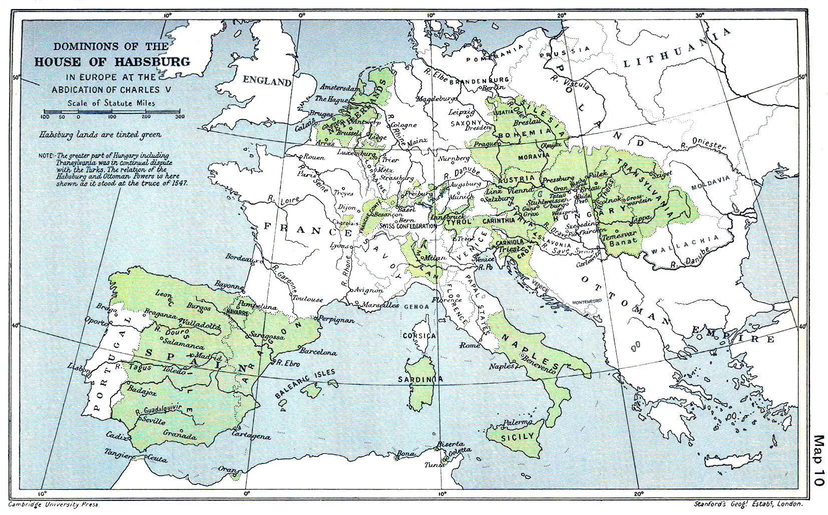
English: A map of the dominion of the Habsburgs following the Battle of Mühlberg (1547) |
| Датум | |
| Извор |
The Cambridge Modern History Atlas, edited by Sir Adolphus William Ward, G.W. Prothero, Sir Stanley Mordaunt Leathes, and E.A. Benians. Cambridge University Press: London, 1912. Editors were Sir Adolphus William Ward (†1924), G.W. Prothero (†1922), and Sir Stanley Mordaunt Leathes (†1938). Individual authors of works making up the atlas are not identified, nor are the likely to be, after reasonable research. |
| Автор | edited by Sir Adolphus William Ward, G.W. Prothero, Sir Stanley Mordaunt Leathes |
| Други верзии |
|

Лиценцирање[уреди]
Ова дело е во јавна сопственост во САД бидејќи е издадено пред 1 јануари 1929 г.
Делата во јавна сопственост мораат да бидат со истечени авторски права како во САД, така и во изворната земја на делото за да можат да бидат на Ризницата. Ако делото не е од САД, тогаш податотеката мора да има дополнителна ознака за авторски права која го назначува нејзиниот статус во изворната земја.
|
This UK artistic or literary work, of which the author is unknown and cannot be ascertained by reasonable enquiry, is in the public domain because it is one of the following:
|
 |
Историја на податотеката
Стиснете на датум/време за да ја видите податотеката како изгледала тогаш.
| Датум/време | Минијатура | Димензии | Корисник | Коментар | |
|---|---|---|---|---|---|
| тековна | 09:20, 29 март 2018 | | 1.654 × 1.029 (534 КБ) | Trecătorul răcit (разговор | придонеси) | Little add: borders of the time |
| 11:01, 3 септември 2015 |  | 1.654 × 1.029 (518 КБ) | Kurzon (разговор | придонеси) | Reverted to version as of 17:22, 9 August 2010 | |
| 11:01, 3 септември 2015 |  | 1.654 × 1.029 (518 КБ) | Kurzon (разговор | придонеси) | Reverted to version as of 17:22, 9 August 2010 | |
| 21:33, 29 јуни 2013 |  | 1.654 × 1.029 (546 КБ) | CSvBibra (разговор | придонеси) | add more contrast per request by another user | |
| 17:22, 9 август 2010 |  | 1.654 × 1.029 (518 КБ) | CSvBibra (разговор | придонеси) | Previously put cleaned up version in new file with "b" after name. Now updating original file with "b" version. Both files uses throughout Wikipedias | |
| 09:07, 28 август 2008 |  | 1.654 × 1.029 (649 КБ) | F l a n k e r (разговор | придонеси) | Wrap, shadows and minor improvements | |
| 14:42, 28 јуни 2005 |  | 1.654 × 1.029 (421 КБ) | Rythin~commonswiki (разговор | придонеси) | A map of the dominion of the Habsburgs following the Battle of Mühlberg (1547). Taken from ''The Cambridge Modern History Atlas,'' edited by Sir Adolphus William Ward, G.W. Prothero, Sir Stanley Mordaunt Leathes, and E.A. Benians. Cambridge University Pr |
Не можете да презапишете врз податотекава.
Употреба на податотеката
Податотекава се користи во следниве 15 страници:
- Atlas of Austria
- Atlas of Belgium
- Atlas of European history
- Atlas of Galicia
- Atlas of Hungary
- Atlas of Italy
- Atlas of Luxembourg
- Atlas of Portugal
- Atlas of Slovenia
- Atlas of Spain
- Atlas of the Czech Republic
- Atlas of the Netherlands
- Maps of Austria
- User:J budissin/Uploads/BiH/2018 March 21-31
- File:Dominions House Habsburg abdication Charles V.jpg
Глобална употреба на податотеката
Оваа податотека ја користат и следниве викија:
- Употреба на af.wikipedia.org
- Употреба на an.wikipedia.org
- Употреба на ar.wikipedia.org
- Употреба на arz.wikipedia.org
- Употреба на ast.wikipedia.org
- Употреба на azb.wikipedia.org
- Употреба на ba.wikipedia.org
- Употреба на be.wikipedia.org
- Употреба на bg.wikipedia.org
- Употреба на br.wikipedia.org
- Употреба на bs.wikipedia.org
- Употреба на ca.wikipedia.org
- Употреба на cs.wikipedia.org
- Употреба на da.wikipedia.org
- Употреба на de.wikipedia.org
- Употреба на el.wikipedia.org
Погледајте ја останатата глобална употреба на податотекава.
Метаподатоци
- 20th-century maps of Europe
- 1547
- Maps of 16th-century Europe
- Old maps of the Holy Roman Empire
- Maps of the history of Spain
- Austrian nobility ruling in Italy
- Nobility of Spain ruling in Italy
- Kingdom of Naples
- Maps of the Kingdom of Sicily
- Maps of the history of Sardinia
- Maps of the Habsburg Monarchy
- Austria in the 16th century
- 1912 maps
- Cambridge Modern History Atlas
- Relations of Austria and Spain