File:Hung Ta-Chen's Map.jpg

Original file (545 × 666 pixels, file size: 103 KB, MIME type: image/jpeg)
Captions
Captions
Summary
[edit]
| Description |
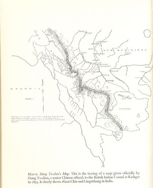
English: Hung Ta Chen’s map. This is the faithful representation of a map officially given by Hung Ta Chen, a senior Chinese Government official, to the British Indian consul at Kashgar, in 1893. The Chinese imperial map clearly depicts the major part of Lingzi Thang, Aksai Chin and Raskam areas in Kashmir as part of Kashmir itself during the relevant period. The map was created by Hung Ta-Chen and it shows that the portion of Aksai Chin to the west of the Macartney-MacDonald line was an integral part of Kashmir and not disputed. The map is reproduced in all “noteworthy” books dealing with India’s border issue, including “Himalayan Frontiers” by Dorothy Woodman published inter alia by London Barrie and Rockliff The Cresset Press 1969. |
| Date | |
| Source | Government of China |
| Author | Government of China |
Licensing
[edit]
This image is now in the public domain in China because its term of copyright has expired. According to copyright laws of the People's Republic of China (with legal jurisdiction in the mainland only, excluding Hong Kong and Macao), amended November 11, 2020, Works of legal persons or organizations without legal personality, or service works, or audiovisual works, enter the public domain 50 years after they were first published, or if unpublished 50 years from creation. For photography works of natural persons whose copyright protection period expires before June 1, 2021 belong to the public domain. All other works of natural persons enter the public domain 50 years after the death of the creator. To uploader: Please provide where the image was first published and who created it or held its copyright.
|
  |
This work is in the public domain in the United States because it meets three requirements:
For background information, see the explanations on Non-U.S. copyrights.
Note: This tag should not be used for sound recordings. |
Original upload log
[edit]
Transferred from en.wikipedia to Commons using For the Common Good.
| Date/Time | Dimensions | User | Comment |
|---|---|---|---|
| 08:09, 18 February 2009 | 545 × 666 (105,967 bytes) | w:en:Hindutashravi (talk | contribs) | Hung Ta Chen’s map . This is the tracing of a map given officially by Hung Ta Chen, a senior Chinese official, to The British Indian Counsel at Kashgar, in 1893. An imperialist map of the Chinese during the relevant period, It clearly depicts the major |
File history
Click on a date/time to view the file as it appeared at that time.
| Date/Time | Thumbnail | Dimensions | User | Comment | |
|---|---|---|---|---|---|
| current | 06:12, 9 January 2014 | | 545 × 666 (103 KB) | The Discoverer (talk | contribs) | Transferred from en.wikipedia: see original upload log above |
You cannot overwrite this file.
File usage on Commons
There are no pages that use this file.
File usage on other wikis
The following other wikis use this file:
- Usage on ar.wikipedia.org
- Usage on as.wikipedia.org
- Usage on bn.wikipedia.org
- Usage on en.wikipedia.org
- Usage on es.wikipedia.org
- Usage on fr.wikipedia.org
- Usage on id.wikipedia.org
- Usage on or.wikipedia.org
- Usage on te.wikipedia.org
- Usage on uz.wikipedia.org
- Usage on vi.wikipedia.org