File:Map of Spanish Louisiana and the American colonies) - J. Gibson, sculp. NYPL434043.tiff
Jump to navigation
Jump to search

Size of this JPG preview of this TIF file: 522 × 600 pixels. Other resolutions: 209 × 240 pixels | 418 × 480 pixels | 668 × 768 pixels | 891 × 1,024 pixels | 1,782 × 2,048 pixels | 3,040 × 3,494 pixels.
Original file (3,040 × 3,494 pixels, file size: 30.4 MB, MIME type: image/tiff)
Captions
Captions
Add a one-line explanation of what this file represents
Summary[edit]
| Description | [Map of Spanish Louisiana and the American colonies] / J. Gibson, sculp.; Maps of North America. / Countries / United States (except New York) / Whole | |||||||||||||||||||||||
| Notes | Bancroft Collection. ''Note 2.'') Does not cover New England. ''Note 3.'') National Endowment for the Humanities Grant for Access to Early Maps of the Middle Atlantic Seaboard. ''Note 4.'') Prime meridian: London. ''Note 5.'') Published with the article Some account of Louisiana ... (The Gentleman's magazine, v. 33, for June 1763 (London), p. 283-288). ''Note 6.'') Relief shown pictorially. ''Note 7.'') Title supplied by cataloger. | |||||||||||||||||||||||
| Item physical description | 1 map ; 17 x 23 cm. | |||||||||||||||||||||||
| Catalogue call number | Map Div. 01-5238 [Filed with America, North, [1750?], as originally cataloged in NYPL Dictionary Catalog of the Map Division] | |||||||||||||||||||||||
| Standard reference | Jolly, D.C. Maps of America in periodicals before 1800, 220; NYPL. Dictionary catalog of the Map Division, I, p. 238 | |||||||||||||||||||||||
| Date | ||||||||||||||||||||||||
| Source |
http://digitalgallery.nypl.org/nypldigital/dgkeysearchdetail.cfm?imageID=434043
|
|||||||||||||||||||||||
| Author | J. (John) -- Engraver Gibson | |||||||||||||||||||||||
| Permission (Reusing this file) |
From The Lionel Pincus and Princess Firyal Map Division. http://maps.nypl.org
|
|||||||||||||||||||||||
| Location | Stephen A. Schwarzman Building / The Lionel Pincus and Princess Firyal Map Division | |||||||||||||||||||||||
| Digital item published | 2-3-2004; updated 3-25-2011 | |||||||||||||||||||||||
| Digital ID | 434043 | |||||||||||||||||||||||

The making of this file was supported by Wikimedia UK.
To see other files made with the support of Wikimedia UK, please see the category Supported by Wikimedia UK.
|
File history
Click on a date/time to view the file as it appeared at that time.
| Date/Time | Thumbnail | Dimensions | User | Comment | |
|---|---|---|---|---|---|
| current | 23:26, 9 May 2014 | 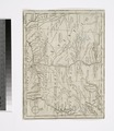 | 3,040 × 3,494 (30.4 MB) | Fæ (talk | contribs) | GWToolset: Creating mediafile for Fæ. Tranche 4 -12906 @11:45 BST, 9 May 2014 |
You cannot overwrite this file.
File usage on Commons
There are no pages that use this file.