File:North America, agreeable to the most approved maps and charts - by Thos. Conder. NYPL434858.tiff
Jump to navigation
Jump to search

Size of this JPG preview of this TIF file: 764 × 600 pixels. Other resolutions: 306 × 240 pixels | 612 × 480 pixels | 979 × 768 pixels | 1,280 × 1,005 pixels | 2,560 × 2,009 pixels | 5,835 × 4,580 pixels.
Original file (5,835 × 4,580 pixels, file size: 76.46 MB, MIME type: image/tiff)
Captions
Captions
Add a one-line explanation of what this file represents
Summary
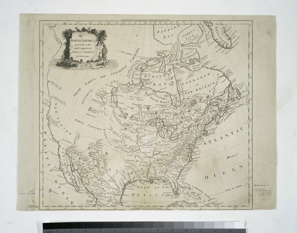
[edit]| Description | North America, agreeable to the most approved maps and charts / by Thos. Conder.; Maps of North America. / Parts | |||||||||||||||||||||||
| Notes | "Engraved for Moore's New and compleat collection of voyages and travels." ''Note 2.'') Bancroft Collection. ''Note 3.'') Includes decorative cartouche. ''Note 4.'') National Endowment for the Humanities Grant for Access to Early Maps of the Middle Atlantic Seaboard. ''Note 5.'') Prime meridian: London. ''Note 6.'') Relief shown pictorially. | |||||||||||||||||||||||
| Item physical description | 1 map ; 33 x 37 cm. | |||||||||||||||||||||||
| Catalogue call number | Map Div. 01-5202 | |||||||||||||||||||||||
| Standard reference | NYPL. Dictionary catalog of the Map Division, I, p. 242 | |||||||||||||||||||||||
| Date | circa 1774 | |||||||||||||||||||||||
| Source |
http://digitalgallery.nypl.org/nypldigital/dgkeysearchdetail.cfm?imageID=434858
|
|||||||||||||||||||||||
| Author | Thomas, 1746 or 7-1831 -- Engraver Conder | |||||||||||||||||||||||
| Permission (Reusing this file) |
From The Lionel Pincus and Princess Firyal Map Division. http://maps.nypl.org
|
|||||||||||||||||||||||
| Location | Stephen A. Schwarzman Building / The Lionel Pincus and Princess Firyal Map Division | |||||||||||||||||||||||
| Digital item published | 2-3-2004; updated 3-25-2011 | |||||||||||||||||||||||
| Digital ID | 434858 | |||||||||||||||||||||||

The making of this file was supported by Wikimedia UK.
To see other files made with the support of Wikimedia UK, please see the category Supported by Wikimedia UK.
|
File history
Click on a date/time to view the file as it appeared at that time.
| Date/Time | Thumbnail | Dimensions | User | Comment | |
|---|---|---|---|---|---|
| current | 17:48, 20 October 2023 |  | 5,835 × 4,580 (76.46 MB) | Sebastian Wallroth (talk | contribs) | Rotated 270° using CropTool with lossless mode. |
| 15:47, 2 May 2014 |  | 4,584 × 5,835 (76.53 MB) | Fæ (talk | contribs) | GWToolset:: Creating mediafile for Fæ. Tranche 3 11591-16518 @ 2 May, 06:47 BST |
You cannot overwrite this file.
File usage on Commons
There are no pages that use this file.