File:Quebec province topographic map-fr.svg
跳转到导航
跳转到搜索

此SVG文件的PNG预览的大小:484 × 600像素。 其他分辨率:194 × 240像素 | 387 × 480像素 | 620 × 768像素 | 826 × 1,024像素 | 1,652 × 2,048像素 | 1,261 × 1,563像素。
原始文件 (SVG文件,尺寸为1,261 × 1,563像素,文件大小:956 KB)
说明
说明
添加一行文字以描述该文件所表现的内容
本图像被选为2009年11月25日的今日图片。其说明如下: 其他语言:
Bosanski: Topografska mapa Kvebeka (Kanada) na francuskom sa gradovima iz popisa 2000. Français : Carte topographique en français du Québec, Canada, avec agglomérations suivant le recensement de 2000. Italiano: Carta topografica in francese della provincia canadese del Québec aggiornata secondo i dati del censimento del 2000. Magyar: A kanadai Québec tartomány francia nyelvű topográfiai térképe a 2000-es népszámlálás szerinti városok feltüntetésével Nederlands: Franstalige topografische kaart van de Canadese (Franssprekende) provincie Québec met de steden van de volkstelling van 2002 Polski: Topograficzna mapa Quebecu (Kanada) w języku francuskim. Português: Mapa topográfico em francês do Quebeque, Canadá, com as cidades do censo de 2000. Македонски: Топографска карта на покраината Квебек, Канада, на француски јазик. Русский: Физическая карта провинции Квебек (Канада) на французском языке. Использованы данные переписи 2000 года. Українська: Фізична карта провінції Квебек, Канада французькою мовою. Наведені дані перепису населення 2000 року. বাংলা : ফরাসী ভাষায় লিখিত কানাডার, কুইবেক অঙ্গরাজ্যের প্রাকৃতিক মানচিত্র। প্রায় ২০০০ শহর উল্লেখিত রয়েছে। 中文: 加拿大魁北克地形学法文地图,根据2000年城市人口普查数据绘制 中文(繁體): 加拿大魁北克地形學法文地圖,根據2000年城市人口普查數據繪製 |
|

摘要[编辑]
| 相机位置 | | 在以下服务上查看本图像和附近其他图像: OpenStreetMap |
|---|
| 描述 |
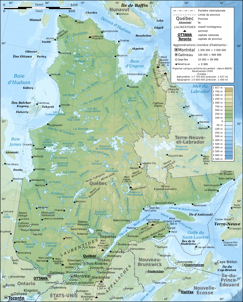
English: Topographic map in French of Quebec, Canada, with 2000' census cities. Note: The background map is a raster image embedded in the SVG file. Français : Carte topographique en français du Québec, Canada, avec agglomérations suivant le recensement de 2000.
Note : Le fond de carte est une image bitmap embarquée dans le fichier SVG.
|
||
| 日期 | |||
| 来源 |
Own work ;
|
||
| 作者 | Eric Gaba (Sting - fr:Sting) | ||
| 授权 (二次使用本文件) |
|
||
| 其他版本 |
[]
Same base map but with topography and without transportation:
Same map, but with an extra layer containing locations of Hydro-Québec's generating stations and 735 kV lines and substations
|


|
此SVG檔案包含可翻譯至您的語言的内嵌文字,可以使用任何可用SVG編輯器、文本編輯器或SVG翻譯工具來翻譯。詳情請見:關於翻譯SVG檔案。 |
许可协议[编辑]
我,本作品著作权人,特此采用以下许可协议发表本作品:

|
已授权您依据自由软件基金会发行的无固定段落及封面封底文字(Invariant Sections, Front-Cover Texts, and Back-Cover Texts)的GNU自由文件许可协议1.2版或任意后续版本的条款,复制、传播和/或修改本文件。该协议的副本请见“GNU Free Documentation License”。 |
This file is licensed under the Creative Commons Attribution-Share Alike 4.0 International, 3.0 Unported, 2.5 Generic, 2.0 Generic and 1.0 Generic license.
- 您可以自由地:
- 共享 – 复制、发行并传播本作品
- 修改 – 改编作品
- 惟须遵守下列条件:
- 署名 – 您必须对作品进行署名,提供授权条款的链接,并说明是否对原始内容进行了更改。您可以用任何合理的方式来署名,但不得以任何方式表明许可人认可您或您的使用。
- 相同方式共享 – 如果您再混合、转换或者基于本作品进行创作,您必须以与原先许可协议相同或相兼容的许可协议分发您贡献的作品。
您可以选择您需要的许可协议。
文件历史
点击某个日期/时间查看对应时刻的文件。
| 日期/时间 | 缩略图 | 大小 | 用户 | 备注 | |
|---|---|---|---|---|---|
| 当前 | 2009年3月3日 (二) 13:43 | | 1,261 × 1,563(956 KB) | Sting(留言 | 贡献) | Correction ; + additional labels |
| 2009年3月3日 (二) 00:04 |  | 1,261 × 1,563(949 KB) | Sting(留言 | 贡献) | == Summary == {{Location|54|00|00|N|68|30|00|W|scale:10000000}} <br/> {{Information |Description={{en|Topographic map in French of Quebec, Canada, with 2000' census cities.}} {{fr|Carte topographique en français du [[:fr:Qu� |
您不可以覆盖此文件。
文件用途
以下61个页面使用本文件:
- User:Giorgi Balakhadze/Gallery
- User:JoKalliauer/SVG test suites/Featured details
- User:Sting/Gallery: Regional maps
- User:Ö/Best/2009
- User talk:Sting/Archive 01
- Commons:Featured picture candidates/File:Quebec province topographic map-fr.svg
- Commons:Featured picture candidates/Log/March 2009
- Commons:Featured pictures/Non-photographic media/Maps
- Commons:Featured pictures/chronological/2009-A
- Commons:Picture of the Year/2009/Galleries/2009-A
- Commons:Picture of the Year/2009/Galleries/All
- Commons:Picture of the Year/2009/Galleries/Diagrams
- Commons:Picture of the Year/2009/Galleries/Index/3
- Commons:Picture of the Year/2009/Galleries/Index/Diagrams
- Commons:Picture of the Year/2009/Galleries/Table/200903
- Commons:Picture of the Year/2009/R1/File:Quebec province topographic map-fr.svg
- Commons:Picture of the Year/2009/Results/R1/ALL/Table
- Commons:Picture of the Year/2009/Results/R1/Diagrams
- Commons:Picture of the Year/2009/Results/R1/Diagrams/Table
- Commons:Potd/2009-11 (da)
- Commons:Potd/2009-11 (de)
- Commons:Potd/2009-11 (eo)
- Commons:Potd/2009-11 (nl)
- Commons:Potd/2009-11 (pt)
- Commons:Potd/2009-11 (tr)
- File:Quebec Map with Hydro-Québec infrastructures-en.png
- File:Quebec Map with Hydro-Québec infrastructures-en.svg
- File:Quebec Map with Hydro-Québec infrastructures-fr.png
- File:Quebec Map with Hydro-Québec infrastructures-fr.svg
- File:Quebec province topographic map-blank.svg
- File:Quebec province topographic map-fr.svg
- File:Quebec province topographic map-it.svg
- File:Quebec province topographic map-ru.svg
- File:Quebec province transportation and cities map-fr.jpg
- File:Quebec province transportation and cities map-fr.svg
- File:Sagamie.svg
- File:Vallée de la Matapedia.svg
- Template:Other versions/Quebec province map
- Template:Potd/2009-11
- Template:Potd/2009-11-25
- Template:Potd/2009-11-25 (bn)
- Template:Potd/2009-11-25 (bs)
- Template:Potd/2009-11-25 (cs)
- Template:Potd/2009-11-25 (cy)
- Template:Potd/2009-11-25 (da)
- Template:Potd/2009-11-25 (de)
- Template:Potd/2009-11-25 (en)
- Template:Potd/2009-11-25 (es)
- Template:Potd/2009-11-25 (fr)
- Template:Potd/2009-11-25 (hu)
- Template:Potd/2009-11-25 (it)
- Template:Potd/2009-11-25 (mk)
- Template:Potd/2009-11-25 (nl)
- Template:Potd/2009-11-25 (pam)
- Template:Potd/2009-11-25 (pl)
- Template:Potd/2009-11-25 (pt)
- Template:Potd/2009-11-25 (ru)
- Template:Potd/2009-11-25 (uk)
- Template:Potd/2009-11-25 (zh-hans)
- Template:Potd/2009-11-25 (zh-hant)
- Template:Potd/2009-11 (zh-hans)
全域文件用途
以下其他wiki使用此文件:
- af.wikipedia.org上的用途
- ba.wikipedia.org上的用途
- bn.wikipedia.org上的用途
- crh.wikipedia.org上的用途
- cs.wikipedia.org上的用途
- cv.wikipedia.org上的用途
- da.wikipedia.org上的用途
- en.wikipedia.org上的用途
- et.wikipedia.org上的用途
- frp.wikipedia.org上的用途
- fr.wikipedia.org上的用途
- Géographie du Québec
- Utilisateur:Sting
- Québec
- Araignées du Québec
- Wikipédia:Image du jour/mars 2009
- Projet:Cartographie/Cartes standards/Pays
- Wikipédia:Atelier graphique/Cartes/Archives/mars 2009
- Wikipédia:Image du jour/29 mars 2009
- Wikipédia:Atelier graphique/Cartes/Archives/juin 2009
- Wikipédia:Atelier graphique/Cartes/Archives/avril 2010
- Wikipédia:Atelier graphique/Cartes/Archives/Demandes mises en sommeil/Europe
- hu.wikipedia.org上的用途
- is.wikipedia.org上的用途
- ko.wikipedia.org上的用途
- krc.wikipedia.org上的用途
- lbe.wikipedia.org上的用途
- lmo.wikipedia.org上的用途
- mk.wikipedia.org上的用途
- nl.wikipedia.org上的用途
- oc.wikipedia.org上的用途
- os.wikipedia.org上的用途
- pam.wikipedia.org上的用途
- pl.wikipedia.org上的用途
- pt.wikipedia.org上的用途
- ru.wikipedia.org上的用途
- ru.wikinews.org上的用途
- sah.wikipedia.org上的用途
- sn.wikipedia.org上的用途
- sv.wikipedia.org上的用途
- uk.wikipedia.org上的用途
查看本文件的更多全域用途。