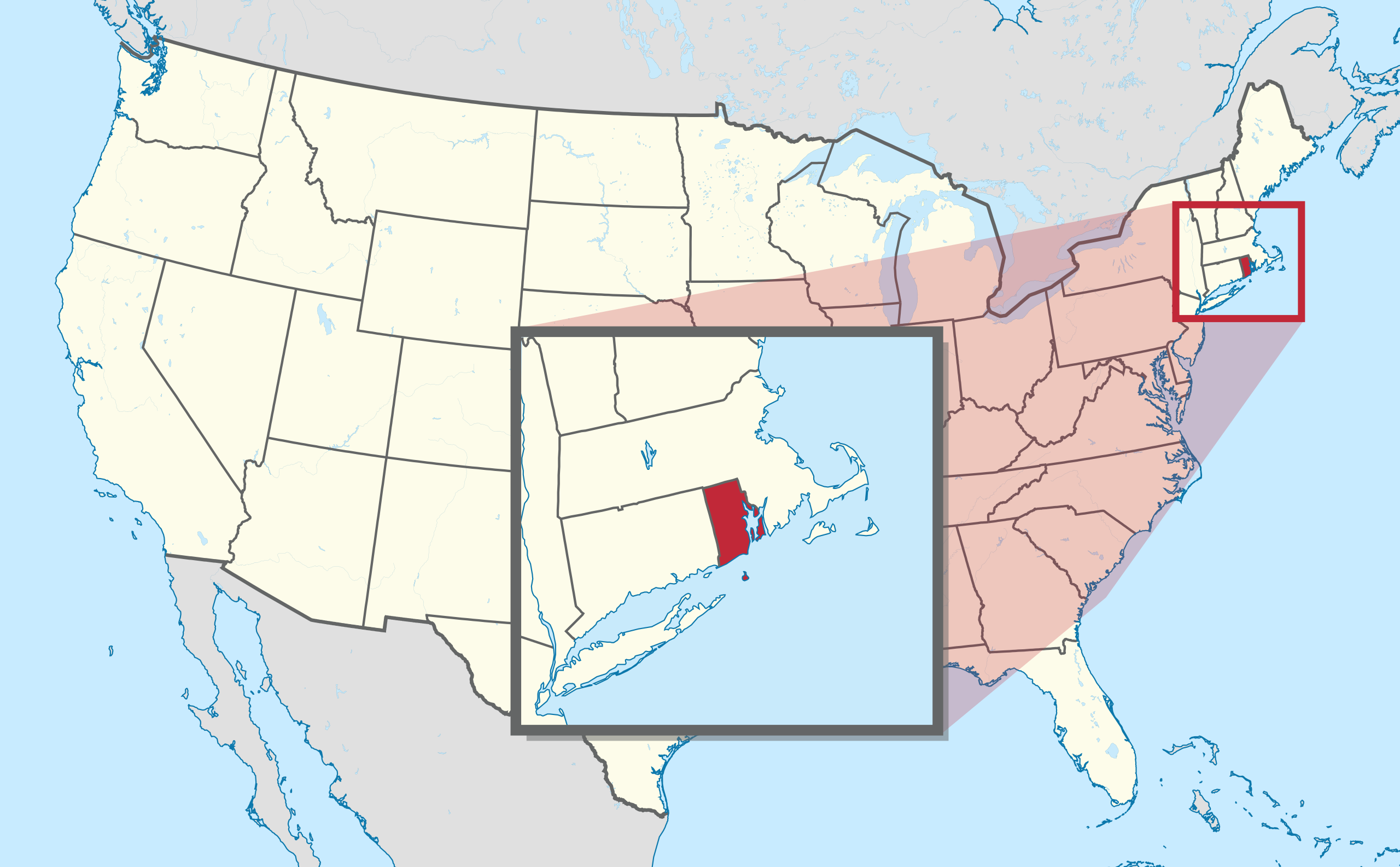
File:Rhode Island in United States (zoom) (extra close) (US48).svg
跳转到导航
跳转到搜索

此SVG文件的PNG预览的大小:800 × 495像素。 其他分辨率:320 × 198像素 | 640 × 396像素 | 1,024 × 634像素 | 1,280 × 792像素 | 2,560 × 1,585像素 | 1,181 × 731像素。
原始文件 (SVG文件,尺寸为1,181 × 731像素,文件大小:1.28 MB)
说明
说明
添加一行文字以描述该文件所表现的内容
摘要[编辑]
.svg)
.svg)
.svg)
.svg)
.svg)
.svg)
.svg)

-en.svg)

.svg)
.svg)
.svg)

_(US48).svg)
_(small_islands_magnified)_(-mini_map_-rivers).svg)
.svg)
_(extra_close)_(US48).svg)
.svg)
_(zoom).svg)

.svg)


_(UNMIK).svg)
.svg)
_(disputed_hatched).svg)
_(claimed_and_disputed_hatched).svg)
.svg)
.svg)
_(%2Ball_claims_hatched).svg)

.svg)
_(shade).svg)
_(shade)_(special_marker).svg)
_(-mini_map).svg)
_(-mini_map).svg)
_(-mini_map).svg)


.svg)

.svg)
_(extra_close)_(US48).svg&action=edit§ion=1)
许可协议[编辑]
_(extra_close)_(US48).svg&action=edit§ion=2)
我,本作品著作权人,特此采用以下许可协议发表本作品:

|
已授权您依据自由软件基金会发行的无固定段落及封面封底文字(Invariant Sections, Front-Cover Texts, and Back-Cover Texts)的GNU自由文件许可协议1.2版或任意后续版本的条款,复制、传播和/或修改本文件。该协议的副本请见“GNU Free Documentation License”。 |
本文件采用知识共享署名-相同方式共享 3.0 未本地化版本许可协议授权。
- 您可以自由地:
- 共享 – 复制、发行并传播本作品
- 修改 – 改编作品
- 惟须遵守下列条件:
- 署名 – 您必须对作品进行署名,提供授权条款的链接,并说明是否对原始内容进行了更改。您可以用任何合理的方式来署名,但不得以任何方式表明许可人认可您或您的使用。
- 相同方式共享 – 如果您再混合、转换或者基于本作品进行创作,您必须以与原先许可协议相同或相兼容的许可协议分发您贡献的作品。
您可以选择您需要的许可协议。

|
如果在维基百科或共享资源之外使用,您将此媒体文件归于维基共享资源,我将不胜感激。要在书籍、报纸、博客、网站等出版物中使用,请插入这以下行:
|
_(extra_close)_(US48).svg&action=edit&redlink=1)
文件历史
点击某个日期/时间查看对应时刻的文件。
| 日期/时间 | 缩略图 | 大小 | 用户 | 备注 | |
|---|---|---|---|---|---|
| 当前 | 2012年9月12日 (三) 12:54 | | 1,181 × 731(1.28 MB) | Palosirkka(留言 | 贡献) | Scrubbed with http://codedread.com/scour/ |
| 2011年7月30日 (六) 21:59 |  | 1,181 × 731(2.44 MB) | TUBS(留言 | 贡献) | corr | |
| 2011年7月30日 (六) 21:31 |  | 1,181 × 731(2.44 MB) | TUBS(留言 | 贡献) |
您不可以覆盖此文件。
文件用途
超过100个页面使用本文件。 下面的列表只显示使用本文件的前100个页面。完整列表可用。
_(extra_close)_(US48).svg)
- User:Yug
- File:Lage des Alb-Donau-Kreises in Deutschland.png
- File:Lage des Bodenseekreises in Deutschland.png
- File:Lage des Landkreises Biberach in Deutschland.png
- File:Lage des Landkreises Loerrach in Deutschland.png
- File:Locator map AC (city) in Germany.svg
- File:Locator map AC (district) in Germany.svg
- File:Locator map AC (region) in Germany.svg
- File:Locator map BGL in Bavaria.svg
- File:Locator map BI in Germany.svg
- File:Locator map BM in Germany.svg
- File:Locator map BN in Germany.svg
- File:Locator map BOR in Germany.svg
- File:Locator map BOT in Germany.svg
- File:Locator map BO in Germany.svg
- File:Locator map Baden-Württemberg in Germany.svg
- File:Locator map Bavaria in Germany.svg
- File:Locator map Berlin in Germany.svg
- File:Locator map Brandenburg in Germany.svg
- File:Locator map Bremen in Germany.svg
- File:Locator map COE in Germany.svg
- File:Locator map DN in Germany.svg
- File:Locator map DO in Germany.svg
- File:Locator map DU in Germany.svg
- File:Locator map D in Germany.svg
- File:Locator map EN in Germany.svg
- File:Locator map EU in Germany.svg
- File:Locator map E in Germany.svg
- File:Locator map FN in Baden-Württemberg.svg
- File:Locator map GE in Germany.svg
- File:Locator map GL in Germany.svg
- File:Locator map GM in Germany.svg
- File:Locator map GT in Germany.svg
- File:Locator map HAM in Germany.svg
- File:Locator map HA in Germany.svg
- File:Locator map HB (Bremen) in Germany.svg
- File:Locator map HB (Bremerhaven) in Germany.svg
- File:Locator map HER in Germany.svg
- File:Locator map HF in Germany.svg
- File:Locator map HSK in Germany.svg
- File:Locator map HS in Germany.svg
- File:Locator map HX in Germany.svg
- File:Locator map Hamburg in Germany.svg
- File:Locator map Hesse in Germany.svg
- File:Locator map KLE in Germany.svg
- File:Locator map KR in Germany.svg
- File:Locator map KS in Germany.svg
- File:Locator map K in Germany.svg
- File:Locator map LEV in Germany.svg
- File:Locator map LIP in Germany.svg
- File:Locator map LVR in Germany.svg
- File:Locator map LWL in Germany.svg
- File:Locator map Lower-Saxony in Germany.svg
- File:Locator map ME in Germany.svg
- File:Locator map MG in Germany.svg
- File:Locator map MH in Germany.svg
- File:Locator map MI in Germany.svg
- File:Locator map MK in Germany.svg
- File:Locator map MS in Germany.svg
- File:Locator map Mecklenburg-Vorpommern in Germany.svg
- File:Locator map NE in Germany.svg
- File:Locator map NF in Germany.svg
- File:Locator map North Rhine-Westphalia in Germany.svg
- File:Locator map OB in Germany.svg
- File:Locator map OE in Germany.svg
- File:Locator map OS in Germany.svg
- File:Locator map PB in Germany.svg
- File:Locator map RB AR in Germany.svg
- File:Locator map RB DT in Germany.svg
- File:Locator map RB D in Germany.svg
- File:Locator map RB K in Germany.svg
- File:Locator map RB MS in Germany.svg
- File:Locator map RE in Germany.svg
- File:Locator map RS in Germany.svg
- File:Locator map RVR in Germany.svg
- File:Locator map Rhineland-Palatinate in Germany.svg
- File:Locator map SG in Germany.svg
- File:Locator map SI in Germany.svg
- File:Locator map SLS in Saarland.svg
- File:Locator map SO in Germany.svg
- File:Locator map ST in Germany.svg
- File:Locator map SU in Germany.svg
- File:Locator map Saarland in Germany.svg
- File:Locator map Saxony-Anhalt in Germany.svg
- File:Locator map Saxony in Germany.svg
- File:Locator map Schleswig-Holstein in Germany.svg
- File:Locator map Thuringia in Germany.svg
- File:Locator map UN in Germany.svg
- File:Locator map VIE in Germany.svg
- File:Locator map WAF in Germany.svg
- File:Locator map WES in Germany.svg
- File:Locator map WIL in Rhineland-Palatinate.svg
- File:Locator map W in Germany.svg
- File:Municipio 1 in Milan.svg
- File:Municipio 2 in Milan.svg
- File:Municipio 3 in Milan.svg
- File:Municipio 4 in Milan.svg
- File:Municipio 5 in Milan.svg
- File:Municipio 6 in Milan.svg
- File:Municipio 7 in Milan.svg
_in_Germany.svg)
_in_Germany.svg)
_in_Germany.svg)
_in_Germany.svg)
_in_Germany.svg)
查看连接到这个文件的更多链接。
全域文件用途
以下其他wiki使用此文件:
- be.wikipedia.org上的用途
- el.wikipedia.org上的用途
- eml.wikipedia.org上的用途
- en.wikipedia.org上的用途
- Mount Hope Bridge
- Rhode Island State House
- Ladd Observatory
- Block Island Southeast Light
- Point Judith Light
- Rose Island Light
- Wilcox Park
- National Register of Historic Places listings in Rhode Island
- Roger Williams National Memorial
- Pawtuxet Village
- Newport Harbor Light
- Beneficent Congregational Church
- The Towers (Narragansett, Rhode Island)
- Redwood Library and Athenaeum
- Ida Lewis Rock Light
- Fleur-de-lys Studios
- National Register of Historic Places listings in Bristol County, Rhode Island
- National Register of Historic Places listings in Kent County, Rhode Island
- National Register of Historic Places listings in Newport County, Rhode Island
- National Register of Historic Places listings in Providence County, Rhode Island
- National Register of Historic Places listings in Washington County, Rhode Island
- Old State House (Providence, Rhode Island)
- College Hill Historic District (Providence, Rhode Island)
- John N. A. Griswold House
- National Register of Historic Places listings in Providence, Rhode Island
- National Register of Historic Places listings in Pawtucket, Rhode Island
- Providence City Hall
- Belton Court
- Bristol Ferry Light
- Hog Island Shoal Light
- Nayatt Point Light
- William Whalley Homestead
- Fort Hamilton Historic District
- Charles H. Baldwin House
- Tiverton Four Corners Historic District
- Block Island North Light
- Plum Beach Light
- Bourne Mill (Tiverton, Rhode Island)
- Cook–Bateman Farm
- Little Compton Common Historic District
查看本文件的更多全域用途。
_(extra_close)_(US48).svg)
_(extra_close)_(US48).svg&oldid=564312815)