File:Thraciae-veteris-typvs.jpg
Ir a la navegación
Ir a la búsqueda
Tamaño de esta previsualización: 780 × 600 píxeles. Otras resoluciones: 312 × 240 píxeles | 624 × 480 píxeles | 999 × 768 píxeles | 1280 × 984 píxeles | 2560 × 1969 píxeles | 4452 × 3424 píxeles.
Archivo original (4452 × 3424 píxeles; tamaño de archivo: 3,59 MB; tipo MIME: image/jpeg)
Leyendas
Leyendas
Añade una explicación corta acerca de lo que representa este archivo
Resumen
[editar]| Descripción |
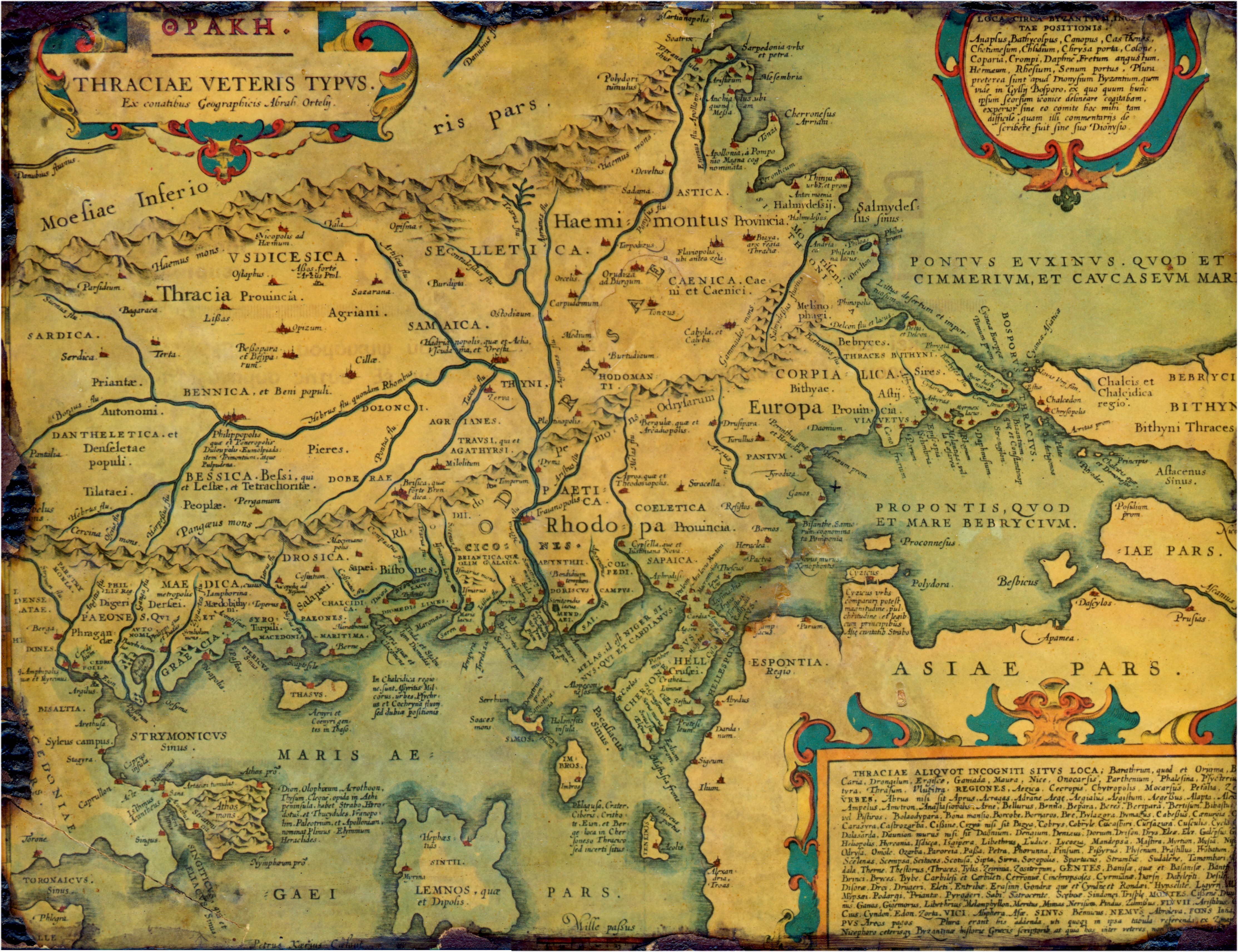
English: Old, historical map of ancient Thrace, mostly in Latin and very few Greek, made in 1585. The map also shows part of Asia minor, Moesia inferior, & ancient Greece along with some Aegan islands. There is some anachronism on the map, such as Moesia inferior and other features.
Français : Vieille carte historique de la Thrace antique, principalement en latin avec un petit peu de grec, faite en 1585. La carte montre également une partie de l'Asie mineure, la Mésie inférieure, et la Grèce antique avec quelques îles égéennes. Il y a des anachronismes sur la carte, tels que la Mésie inférieure et d'autres caractéristiques. |
|||||||||||||||||||||||
| Fecha | ||||||||||||||||||||||||
| Fuente | Thraciae veteris typvs . . . 1585 | |||||||||||||||||||||||
| Autor |
|
|||||||||||||||||||||||
| Permiso (Reutilización de este archivo) |
PD-Art | |||||||||||||||||||||||

Licencia
[editar]
|
Esta es una reproducción fotográfica fiel de una obra de arte bidimensional de dominio público. La obra de arte misma se halla en el dominio público por el motivo siguiente:
La postura oficial de la Fundación Wikimedia considera que «las reproducciones fieles de obras de arte bidimensionales de dominio público forman parte del dominio público».
Esta reproducción fotográfica, por ende, también se considera de dominio público dentro de los Estados Unidos. Es posible que otras jurisdicciones restrinjan la reutilización de este contenido; consúltese Reutilización de fotografías PD-Art (en inglés) para más detalles. | ||||
Esta imagen es considerada imagen de calidad después de haber sido evaluada según la guía para imágenes de calidad.
|
Historial del archivo
Haz clic sobre una fecha y hora para ver el archivo tal como apareció en ese momento.
| Fecha y hora | Miniatura | Dimensiones | Usuario | Comentario | |
|---|---|---|---|---|---|
| actual | 21:58 12 jul 2006 | | 4452 × 3424 (3,59 MB) | Adamantios (discusión | contribs.) | {{Information |Description=Old, historical map of Thrace. |Source=copy of framed gravure |Date=copied on July of 2006 |Author=unknown |Permission=PD-old |other_versions= }} Category:Old maps of the Balkans Category:History of the Balkans |
No puedes sobrescribir este archivo.
Usos del archivo
Las siguientes páginas usan este archivo:
- Ancient Thrace and ancient Thracians
- Atlas of Bulgaria
- Atlas of European history
- Atlas of Greece
- Atlas of Turkey
- Atlas of the antiquity
- User:Adamantios
- User:Adamantios/Third party media
- User talk:Adamantios
- Commons:Featured picture candidates/Image:Thraciae-veteris-typvs.jpg
- Commons:Featured picture candidates/Log/May 2008
- Commons:Quality images/Subject/Objects/Other/Archive
- Commons:Quality images candidates/Archives July 2007
Uso global del archivo
Las wikis siguientes utilizan este archivo:
- Uso en af.wikipedia.org
- Uso en ast.wikipedia.org
- Uso en bg.wikipedia.org
- Uso en br.wikipedia.org
- Uso en ca.wikipedia.org
- Uso en cs.wikipedia.org
- Uso en da.wikipedia.org
- Uso en de.wikipedia.org
- Uso en el.wikipedia.org
- Uso en en.wikipedia.org
- Aegospotami
- Thrace
- Perinthus
- Plovdiv
- Thynia
- Ismarus (Thrace)
- Dionysupolis
- Agora (Thrace)
- Zerynthus
- Delkos
- Heraclea Sintica
- Apollonia (Kavala)
- Bisanthe
- Bergule
- Galepsus (Thrace)
- List of ancient cities in Thrace and Dacia
- List of kings of Thrace and Dacia
- Pistyrus
- Crenides (Macedonia)
- Myrcinus
- Neapolis (Thrace)
- Oesyme
- Sirra
- Bergepolis
- Larissa (Homeric city)
- Sale (Thrace)
- Stryme
- Drys (Thrace)
- Dicaea (Thrace)
- Cypsela (Thrace)
- Orthagoria
- Zone (colony)
- Araplus
- Alopeconnesus
- Deris (Thrace)
- Pactya
Ver más uso global de este archivo.
Metadatos
Categorías:
- Maps by Abraham Ortelius
- Maps of the history of the ancient Balkans
- 16th-century maps of the Sea of Marmara
- 16th-century maps of the Aegean Sea
- 16th-century maps of the Black Sea
- 1580s maps of Greece
- Maps of the history of Bulgaria in ancient times
- Maps of ancient Thrace
- Old maps of Thrace
- Moesia Inferior
- 16th-century maps showing history