File:Toolbox SVG locator maps (location map based)-en.svg
Zur Navigation springen
Zur Suche springen

Gröössi vor PNG-Vorschou vor SVG-Datei: 680 × 599 Pixel. Wyteri Ufflösige: 272 × 240 Pixel | 545 × 480 Pixel | 871 × 768 Pixel | 1.162 × 1.024 Pixel | 2.323 × 2.048 Pixel | 962 × 848 Pixel.
Originaldatei (SVG-Datei, Basisgrößi: 962 × 848 Pixel, Dateigrößi: 61 KB)
Bildtexte
Kurzbeschreibungen
Ergänze eine einzeilige Erklärung, was diese Datei darstellt.
Bschryybig
[ändere].svg)
.svg)
.svg)
.svg)
.svg)
.svg)
.svg)

-en.svg)

.svg)
.svg)
.svg)

_(US48).svg)
_(small_islands_magnified)_(-mini_map_-rivers).svg)
.svg)
_(extra_close)_(US48).svg)
.svg)
_(zoom).svg)

.svg)


_(UNMIK).svg)
.svg)
_(disputed_hatched).svg)
_(claimed_and_disputed_hatched).svg)
.svg)
.svg)
_(%2Ball_claims_hatched).svg)

.svg)
_(shade).svg)
_(shade)_(special_marker).svg)
_(-mini_map).svg)
_(-mini_map).svg)
_(-mini_map).svg)


.svg)

.svg)
-en.svg&action=edit§ion=1)
Lizänzierig
[ändere]-en.svg&action=edit§ion=2)
Ich haa s Urheberrächt an däm Wärch un vereffetlig s dodermit unter däne Lizänze:

|
Des Dokumänt derf kopiert, verbreitet un/oder bearbeitet wäre unter dr Bedingige vu dr GNU-Lizänz fir freji Dokumäntation, Version 1.2 oder ere spetere Version, vereffetligt dur Free Software Foundation. S het keini uuveränderlige Abschnitt, kei vordere Umschlagstext un kei hindere Umschlagstext. E Kopii vu dr Lizänz isch verfiegbar im Abschnitt GNU-Lizänz fir freji Dokumäntation. |
Die Datei isch lizänziert unter dr Creative-Commons-Lizenz Namensnännig – Wytergab unter glyche Bedingige 3.0 nit portiert.
- Du derfsch:
- des Wärch an anderi wytergee – des Wärch kopiere, verbreite un ibertrage
- des Wärch verändere – des Wärch aapasse
- Unter däne Bedingige:
- Namenännig – Du muesch aagmässeni Aagabe zum Urheber un dr Rächt mache, e Link zue dr Lizänz zuefiege un aagee, eb Änderige gmacht wore sin. Die Aagabe chenne in ere aagmässene Art gmacht wäre, aber nit eso, ass dr Yydruck entstoht, ass dr Lizänzgeber Dii oder Dyy Gebruch vum Wärch unterstitze un guetheiße.
- Wytergab unter glyche Bedingige – Wänn du des Wärch veränderesch, umwandlesch oder druf ufböusch, no derfsch s Ergebnis nume unter dr glyche oder ere kumpatible Lizänz wie s Orginal vereffetlige.
Du chasch sälber e Lizänz uuswehle.

|
Wenn du die Datei außerhalb der Wikipedia oder Commons verwendest, begrüße ich es, wenn du als Quelle Wikimedia Commons angeben könntest. Wenn du die Datei in einem Buch, Zeitung, Blog, Webseite, etc. verwendest, füge bitte hier folgende Zeile ein:
|
-en.svg&action=edit&redlink=1)
Dateiversione
Klick uf e Zytpunkt zu aazeige, wie s dert usgsäh het.
| Version vom | Vorschaubild | Mäß | Benutzer | Kommentar | |
|---|---|---|---|---|---|
| aktuell | 04:20, 9. Nov. 2023 | | 962 × 848 (61 KB) | Steinninn (Diskussion | Byträg) | Reverted to version as of 20:26, 4 November 2012 (UTC) |
| 16:08, 19. Nov. 2012 |  | 964 × 899 (83 KB) | Yug (Diskussion | Byträg) | Canvas' size fixed. | |
| 16:06, 19. Nov. 2012 |  | 962 × 848 (75 KB) | Yug (Diskussion | Byträg) | hold on please, some changes coming soon. | |
| 20:26, 4. Nov. 2012 |  | 962 × 848 (61 KB) | TUBS (Diskussion | Byträg) | ||
| 20:08, 4. Nov. 2012 |  | 594 × 523 (57 KB) | TUBS (Diskussion | Byträg) | ||
| 20:03, 4. Nov. 2012 |  | 594 × 523 (474 KB) | TUBS (Diskussion | Byträg) | corr | |
| 20:00, 4. Nov. 2012 |  | 594 × 523 (474 KB) | TUBS (Diskussion | Byträg) | corr | |
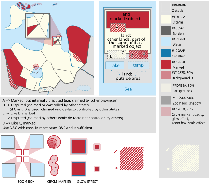
| 19:54, 4. Nov. 2012 |  | 594 × 523 (475 KB) | TUBS (Diskussion | Byträg) | == {{int:filedesc}} == {{Information |Description={{de|Formatvorlagen für Karten der Kategorie SVG locator maps (location map scheme).}} {{en|Toolbox for maps at [[:Category:SVG locator maps (locati... |
Du chasch die Datei nit iberschryybe.
Verwändig vu dr Datei
Meh wie 100 Syte verwyyse uf die Datei. Die Lischt zeigt nume di erschte 100 Link uf die Datei. E vollständigi Lischt isch verfiegbar.
-en.svg)
- User:Yug
- File:Lage des Alb-Donau-Kreises in Deutschland.png
- File:Lage des Bodenseekreises in Deutschland.png
- File:Lage des Landkreises Biberach in Deutschland.png
- File:Lage des Landkreises Loerrach in Deutschland.png
- File:Locator map AC (city) in Germany.svg
- File:Locator map AC (district) in Germany.svg
- File:Locator map AC (region) in Germany.svg
- File:Locator map BGL in Bavaria.svg
- File:Locator map BI in Germany.svg
- File:Locator map BM in Germany.svg
- File:Locator map BN in Germany.svg
- File:Locator map BOR in Germany.svg
- File:Locator map BOT in Germany.svg
- File:Locator map BO in Germany.svg
- File:Locator map Baden-Württemberg in Germany.svg
- File:Locator map Bavaria in Germany.svg
- File:Locator map Berlin in Germany.svg
- File:Locator map Brandenburg in Germany.svg
- File:Locator map Bremen in Germany.svg
- File:Locator map COE in Germany.svg
- File:Locator map DN in Germany.svg
- File:Locator map DO in Germany.svg
- File:Locator map DU in Germany.svg
- File:Locator map D in Germany.svg
- File:Locator map EN in Germany.svg
- File:Locator map EU in Germany.svg
- File:Locator map E in Germany.svg
- File:Locator map FN in Baden-Württemberg.svg
- File:Locator map GE in Germany.svg
- File:Locator map GL in Germany.svg
- File:Locator map GM in Germany.svg
- File:Locator map GT in Germany.svg
- File:Locator map HAM in Germany.svg
- File:Locator map HA in Germany.svg
- File:Locator map HB (Bremen) in Germany.svg
- File:Locator map HB (Bremerhaven) in Germany.svg
- File:Locator map HER in Germany.svg
- File:Locator map HF in Germany.svg
- File:Locator map HSK in Germany.svg
- File:Locator map HS in Germany.svg
- File:Locator map HX in Germany.svg
- File:Locator map Hamburg in Germany.svg
- File:Locator map Hesse in Germany.svg
- File:Locator map KLE in Germany.svg
- File:Locator map KR in Germany.svg
- File:Locator map KS in Germany.svg
- File:Locator map K in Germany.svg
- File:Locator map LEV in Germany.svg
- File:Locator map LIP in Germany.svg
- File:Locator map LVR in Germany.svg
- File:Locator map LWL in Germany.svg
- File:Locator map Lower-Saxony in Germany.svg
- File:Locator map ME in Germany.svg
- File:Locator map MG in Germany.svg
- File:Locator map MH in Germany.svg
- File:Locator map MI in Germany.svg
- File:Locator map MK in Germany.svg
- File:Locator map MS in Germany.svg
- File:Locator map Mecklenburg-Vorpommern in Germany.svg
- File:Locator map NE in Germany.svg
- File:Locator map NF in Germany.svg
- File:Locator map North Rhine-Westphalia in Germany.svg
- File:Locator map OB in Germany.svg
- File:Locator map OE in Germany.svg
- File:Locator map OS in Germany.svg
- File:Locator map PB in Germany.svg
- File:Locator map RB AR in Germany.svg
- File:Locator map RB DT in Germany.svg
- File:Locator map RB D in Germany.svg
- File:Locator map RB K in Germany.svg
- File:Locator map RB MS in Germany.svg
- File:Locator map RE in Germany.svg
- File:Locator map RS in Germany.svg
- File:Locator map RVR in Germany.svg
- File:Locator map Rhineland-Palatinate in Germany.svg
- File:Locator map SG in Germany.svg
- File:Locator map SI in Germany.svg
- File:Locator map SLS in Saarland.svg
- File:Locator map SO in Germany.svg
- File:Locator map ST in Germany.svg
- File:Locator map SU in Germany.svg
- File:Locator map Saarland in Germany.svg
- File:Locator map Saxony-Anhalt in Germany.svg
- File:Locator map Saxony in Germany.svg
- File:Locator map Schleswig-Holstein in Germany.svg
- File:Locator map Thuringia in Germany.svg
- File:Locator map UN in Germany.svg
- File:Locator map VIE in Germany.svg
- File:Locator map WAF in Germany.svg
- File:Locator map WES in Germany.svg
- File:Locator map WIL in Rhineland-Palatinate.svg
- File:Locator map W in Germany.svg
- File:Municipio 1 in Milan.svg
- File:Municipio 2 in Milan.svg
- File:Municipio 3 in Milan.svg
- File:Municipio 4 in Milan.svg
- File:Municipio 5 in Milan.svg
- File:Municipio 6 in Milan.svg
- File:Municipio 7 in Milan.svg
_in_Germany.svg)
_in_Germany.svg)
_in_Germany.svg)
_in_Germany.svg)
_in_Germany.svg)
Meh Links fir die Datei.
Wältwyti Dateinutzig
Die andere Wikis bruche die Datei:
- Gebruch uf en.wikipedia.org
- Gebruch uf zh.wikipedia.org
-en.svg&oldid=819954967)