File:U145 Fällbro - KMB - 16000300012836.jpg
Jump to navigation
Jump to search
Size of this preview: 400 × 600 pixels. Other resolutions: 160 × 240 pixels | 512 × 768 pixels.
Original file (512 × 768 pixels, file size: 167 KB, MIME type: image/jpeg)
Captions
Captions
Add a one-line explanation of what this file represents
| U145 Fällbro
( |
|||||||||||||||||||||||||||
|---|---|---|---|---|---|---|---|---|---|---|---|---|---|---|---|---|---|---|---|---|---|---|---|---|---|---|---|
| Photographer |
|
||||||||||||||||||||||||||
| Title |
U145 Fällbro |
||||||||||||||||||||||||||
| Original caption |
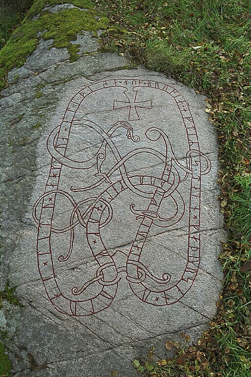
Notera Av dokumentationsskäl har originalbeskrivningen från Riksantikvarieämbetet behållits. Tillrättalägganden och alternativa beskrivningar bör införas separat från nedanstående information. Täby 46:2. Inskriften på runhällen lyder: Torkel och Fulluge lät hugga denna häll och göra bron efter Sten sin fader. Olev högg.Felaktigheter kan även anmälas till denna sida. Motiv: Täby 46:2 |
||||||||||||||||||||||||||
| Description |
Täby 46:2. Inskriften på runhällen lyder: Torkel och Fulluge lät hugga denna häll och göra bron efter Sten sin fader. Olev högg. Täby 46:2. |
||||||||||||||||||||||||||
| Depicted place | Sweden, Täby Municipality, Täby socken, Uppland | ||||||||||||||||||||||||||
| Date | 14 October 1997 | ||||||||||||||||||||||||||
| Collection |
|
||||||||||||||||||||||||||
| Accession number | |||||||||||||||||||||||||||
| Source |
Bengt A Lundberg / Kulturmiljöbild, Riksantikvarieämbetet
|
||||||||||||||||||||||||||
| Permission (Reusing this file) |
This file is licensed under the Creative Commons Attribution 2.5 Generic license. Attribution: Bengt A Lundberg / Riksantikvarieämbetet
|
||||||||||||||||||||||||||


| Object location | | View this and other nearby images on: OpenStreetMap |
|---|
File history
Click on a date/time to view the file as it appeared at that time.
| Date/Time | Thumbnail | Dimensions | User | Comment | |
|---|---|---|---|---|---|
| current | 02:10, 10 June 2017 | | 512 × 768 (167 KB) | AndreCostaWMSE-bot (talk | contribs) | {{Kulturmiljöbild-image | short title = U145 Fällbro | original description = Täby 46:2. Inskriften på runhällen lyder: Torkel och Fulluge lät hugga denna häll och göra bron efter Sten sin fader. Olev högg.<br> Motiv: Täby 46:2<br> Nyckelord:... |
You cannot overwrite this file.
File usage on Commons
The following page uses this file:
File usage on other wikis
The following other wikis use this file:
- Usage on de.wikipedia.org
- Usage on sv.wikipedia.org