File:Vallhagar - KMB - 16001000022982.jpg
Jump to navigation
Jump to search

Size of this preview: 597 × 599 pixels. Other resolutions: 239 × 240 pixels | 478 × 480 pixels | 765 × 768 pixels.
Original file (765 × 768 pixels, file size: 302 KB, MIME type: image/jpeg)
Captions
Captions
Add a one-line explanation of what this file represents
| Vallhagar
( |
|||||||||||||||||||||||||||
|---|---|---|---|---|---|---|---|---|---|---|---|---|---|---|---|---|---|---|---|---|---|---|---|---|---|---|---|
| Photographer |
Lif Alstad |
||||||||||||||||||||||||||
| Title |
Vallhagar |
||||||||||||||||||||||||||
| Original caption |
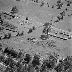
Notera Av dokumentationsskäl har originalbeskrivningen från Riksantikvarieämbetet behållits. Tillrättalägganden och alternativa beskrivningar bör införas separat från nedanstående information. Järnåldersboplats. Hus 9-11. Från NV (25 m).Felaktigheter kan även anmälas till denna sida. Motiv: Vallhagar |
||||||||||||||||||||||||||
| Description |
Järnåldersboplats. Hus 9-11. Från NV (25 m).
|
||||||||||||||||||||||||||
| Depicted place | Sweden, Gotland Municipality, Fröjel socken | ||||||||||||||||||||||||||
| Date | 26 June 1947 | ||||||||||||||||||||||||||
| Collection |
|
||||||||||||||||||||||||||
| Accession number | |||||||||||||||||||||||||||
| Source |
Lif Alstad / Kulturmiljöbild, Riksantikvarieämbetet
|
||||||||||||||||||||||||||
| Permission (Reusing this file) |
|
||||||||||||||||||||||||||


| Object location | | View this and other nearby images on: OpenStreetMap |
|---|
File history
Click on a date/time to view the file as it appeared at that time.
| Date/Time | Thumbnail | Dimensions | User | Comment | |
|---|---|---|---|---|---|
| current | 19:55, 9 June 2017 | | 765 × 768 (302 KB) | AndreCostaWMSE-bot (talk | contribs) | {{Kulturmiljöbild-image | short title = Vallhagar | original description = Järnåldersboplats. Hus 9-11. Från NV (25 m).<br> Motiv: Vallhagar<br> Nyckelord: Flygbilder, Riksintressen<br> Kategori: Husgrund, förhistorisk/medeltida | wiki description... |
You cannot overwrite this file.
File usage on Commons
The following 3 pages use this file: