File:WW2 Holocaust Europe map-fr.svg
Zur Navigation springen
Zur Suche springen

Größe der PNG-Vorschau dieser SVG-Datei: 721 × 600 Pixel. Weitere Auflösungen: 289 × 240 Pixel | 577 × 480 Pixel | 923 × 768 Pixel | 1.231 × 1.024 Pixel | 2.461 × 2.048 Pixel | 1.310 × 1.090 Pixel.
Originaldatei (SVG-Datei, Basisgröße: 1.310 × 1.090 Pixel, Dateigröße: 841 KB)
Bildtexte
Kurzbeschreibungen
Ergänze eine einzeilige Erklärung, was diese Datei darstellt.
Beschreibung[Bearbeiten]
| Beschreibung |
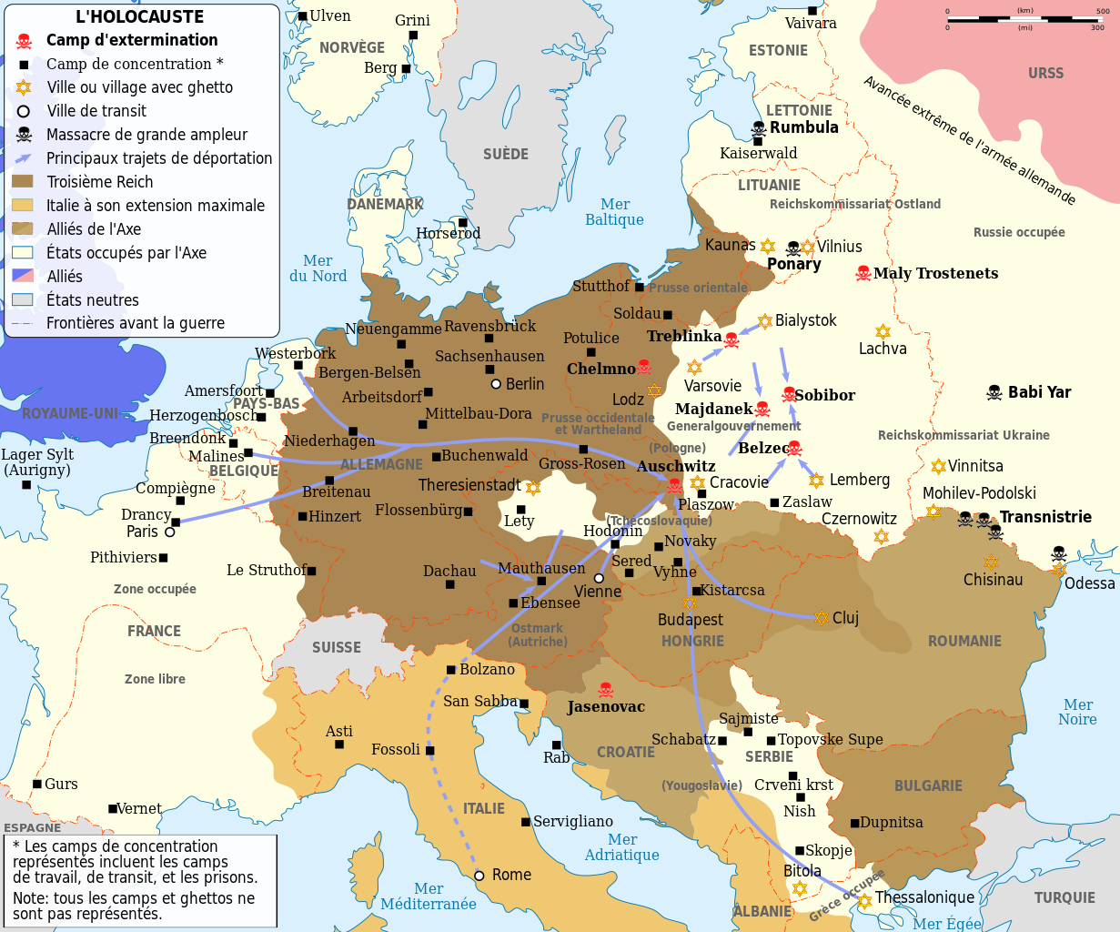
English: Map of the Holocaust in Europe during World War II, 1939-1945. This map shows all extermination camps (or death camps), most major concentration camps, labor camps, prison camps, ghettos, major deportation routes and major massacre sites.
Français : Carte de la Shoah en Europe lors de la Seconde Guerre mondiale (1939-1945). Cette carte montre tous les camps d'extermination (ou « camps de la mort ») et la plupart des principaux camps de concentration, de travail forcé, prisons, itinéraires de déportation et lieux de massacres.
Català: Mapa de L'Holocaust a Europa durant la Segona Guerra Mundial, 1939-1945.
|
||||
| Datum | (UTC) | ||||
| Quelle | |||||
| Urheber |
|
||||
| Andere Versionen |
[]
Abgeleitete Werke dieser Datei:
| ||||
| Namensnennung (von der Lizenz verlangt) | © Sémhur / Wikimedia Commons / | ||||
| SVG |
|
||||
| Graphic Lab |


.png)


.png)


| Kameraposition | | Dieses und weitere Bilder auf OpenStreetMap |
|---|
Lizenz[Bearbeiten]
Ich, der Urheberrechtsinhaber dieses Werkes, veröffentliche es hiermit unter der folgenden Lizenz:
| Copyleft: Dieses Kunstwerk ist frei, es darf weitergegeben und/oder modifiziert werden entsprechend den Bedingungen der Lizenz „Freie Kunst“.
Der vollständige Text der Lizenz steht auf der „Copyleft Attitude“-Seite sowie auf anderen Webseiten. |
Diese Datei ist unter den Creative Commons-Lizenzen Namensnennung – Weitergabe unter gleichen Bedingungen 4.0 International, 3.0 nicht portiert, 2.5 Allgemein, 2.0 Allgemein und 1.0 Allgemein lizenziert.
- Dieses Werk darf von dir
- verbreitet werden – vervielfältigt, verbreitet und öffentlich zugänglich gemacht werden
- neu zusammengestellt werden – abgewandelt und bearbeitet werden
- Zu den folgenden Bedingungen:
- Namensnennung – Du musst angemessene Urheber- und Rechteangaben machen, einen Link zur Lizenz beifügen und angeben, ob Änderungen vorgenommen wurden. Diese Angaben dürfen in jeder angemessenen Art und Weise gemacht werden, allerdings nicht so, dass der Eindruck entsteht, der Lizenzgeber unterstütze gerade dich oder deine Nutzung besonders.
- Weitergabe unter gleichen Bedingungen – Wenn du das Material wiedermischst, transformierst oder darauf aufbaust, musst du deine Beiträge unter der gleichen oder einer kompatiblen Lizenz wie das Original verbreiten.
Du darfst es unter einer der obigen Lizenzen deiner Wahl verwenden.
Ursprüngliches Datei-Logbuch[Bearbeiten]
This image is a derivative work of the following images:
- File:WW2-Holocaust-Europe.png licensed with Cc-by-3.0
- 2007-12-20T03:41:38Z Dna-webmaster 1310x1090 (845818 Bytes) new version without "Axis cooperating" in legend
- 2007-12-20T02:00:30Z Dna-webmaster 1310x1090 (844034 Bytes) Now entire West Prussia and Wartheland is included in the Third Reich
- 2007-12-19T16:42:15Z Dna-webmaster 1310x1090 (847461 Bytes) still not Da Vinci, but errors have been corrected (Germany borders West/East), West & East Prussia borders/coloring and Poland General Government corrected borders.
- 2007-12-17T10:46:28Z Dna-webmaster 1310x1090 (844633 Bytes) new map with 1942 borders, not Da Vinci, but here it goes...
- 2007-10-19T13:32:25Z Dna-webmaster 1310x1090 (784727 Bytes) and another update
- 2007-10-19T12:21:52Z Dna-webmaster 1310x1090 (789383 Bytes) quick fix
- 2007-10-19T12:11:07Z Dna-webmaster 1310x1090 (789413 Bytes) {{Information |Description=Map of the Holocaust in Europe during World War II, 1939-1945. This map shows all extermination camps (or ''death camps''), most major concentration camps, work camps, prison camps, ghettos, major
Hochgeladen mit derivativeFX
Dateiversionen
Klicke auf einen Zeitpunkt, um diese Version zu laden.
| Version vom | Vorschaubild | Maße | Benutzer | Kommentar | |
|---|---|---|---|---|---|
| aktuell | 15:24, 18. Feb. 2024 | | 1.310 × 1.090 (841 KB) | Ispanas (Diskussion | Beiträge) | File uploaded using svgtranslate tool (https://svgtranslate.toolforge.org/). Added translation for lt. |
| 13:30, 18. Feb. 2024 |  | 1.310 × 1.090 (841 KB) | Ispanas (Diskussion | Beiträge) | File uploaded using svgtranslate tool (https://svgtranslate.toolforge.org/). Added translation for lt. | |
| 07:20, 22. Sep. 2023 |  | 1.310 × 1.090 (841 KB) | EnjolrasXXI (Diskussion | Beiträge) | File uploaded using svgtranslate tool (https://svgtranslate.toolforge.org/). Added translation for ca. | |
| 21:25, 27. Aug. 2023 |  | 1.310 × 1.090 (733 KB) | Tholme (Diskussion | Beiträge) | Reverted to version as of 14:45, 28 February 2023 (UTC) | |
| 21:24, 27. Aug. 2023 |  | 1.310 × 1.090 (490 KB) | Tholme (Diskussion | Beiträge) | Reverted to version as of 14:47, 3 June 2021 (UTC) | |
| 14:45, 28. Feb. 2023 |  | 1.310 × 1.090 (733 KB) | Andrei Stroe (Diskussion | Beiträge) | File uploaded using svgtranslate tool (https://svgtranslate.toolforge.org/). Added translation for ro. | |
| 19:26, 29. Okt. 2022 |  | 1.310 × 1.090 (625 KB) | Ispanas (Diskussion | Beiträge) | File uploaded using svgtranslate tool (https://svgtranslate.toolforge.org/). Added translation for lt. | |
| 07:32, 13. Sep. 2021 |  | 1.310 × 1.090 (490 KB) | BIG DADDY Dunkleosteus (Diskussion | Beiträge) | Reverted to version as of 14:47, 3 June 2021 (UTC) | |
| 07:31, 13. Sep. 2021 |  | 1.310 × 1.090 (555 KB) | BIG DADDY Dunkleosteus (Diskussion | Beiträge) | File uploaded using svgtranslate tool (https://svgtranslate.toolforge.org/). Added translation for en. | |
| 14:47, 3. Jun. 2021 |  | 1.310 × 1.090 (490 KB) | Tholme (Diskussion | Beiträge) | remove another nested tspan |
Du kannst diese Datei nicht überschreiben.
Dateiverwendung
Die folgenden 44 Seiten verwenden diese Datei:
- Atlas of World War II
- User:Magog the Ogre/Maps of conflicts/2016 August
- User:Magog the Ogre/Maps of conflicts/2021 June
- User:Magog the Ogre/Maps of conflicts/2021 September
- User:Magog the Ogre/Maps of conflicts/2022 October
- User:Magog the Ogre/Maps of conflicts/2023 August
- User:Magog the Ogre/Maps of conflicts/2023 February
- User:Magog the Ogre/Maps of conflicts/2023 September
- User:Magog the Ogre/Maps of conflicts/2024 February
- User:Magog the Ogre/Multilingual legend/2021 June 1-10
- User:Magog the Ogre/Multilingual legend/2021 September 11-20
- User:Magog the Ogre/Multilingual legend/2022 October 21-31
- User:Magog the Ogre/Multilingual legend/2023 August 27-31
- User:Magog the Ogre/Multilingual legend/2023 February 19-28
- User:Magog the Ogre/Multilingual legend/2023 September 21-25
- User:Magog the Ogre/Multilingual legend/2024 February 15-19
- File:EntenteDeLosBalcanes.svg
- File:PequeñaEntente.svg
- File:WW2-Holocaust-Europe-2007Borders.png
- File:WW2-Holocaust-Europe-2007Borders DE.png
- File:WW2-Holocaust-Europe-he.png
- File:WW2-Holocaust-Europe.png
- File:WW2-Holocaust-Europe (cropped).png
- File:WW2-Holocaust-Europe DE.png
- File:WW2-Holocaust-Europe DE 2.png
- File:WW2-Holocaust-Europe blank.png
- File:WW2-Holocaust-Poland-ru.png
- File:WW2-Holocaust-Poland-ukr.jpg
- File:WW2-Holocaust-Poland.PNG
- File:WW2-Holocaust-Poland (Français).png
- File:WW2-Holocaust-Poland (without comment).png
- File:WW2-Holocaust-Poland big legend.PNG
- File:WW2-Zagłada-Żydów-Polska.png
- File:WW2 Holocaust Europe N-E map-fr.svg
- File:WW2 Holocaust Europe map-blank.svg
- File:WW2 Holocaust Europe map-de.png
- File:WW2 Holocaust Europe map-es.svg
- File:WW2 Holocaust Europe map-fr.svg
- File:WW2 Holocaust Europe map-it.svg
- File:WW2 Holocaust Europe map-pt.svg
- File:WW2 Holocaust Europe map-zh-hans.svg
- File:WW2 Holocaust Poland map-fr.svg
- File:Холокост в Европе.png
- Template:Other versions/WW2 Holocaust Europe map
.png)
Globale Dateiverwendung
Die nachfolgenden anderen Wikis verwenden diese Datei:
- Verwendung auf ca.wikipedia.org
- Verwendung auf de.wikipedia.org
- Verwendung auf en.wikipedia.org
- Verwendung auf fr.wikipedia.org
- Années 1940
- Liste des camps de concentration nazis
- Wikipédia:Atelier graphique/Cartes/Archives/mai 2009
- Shoah
- Convois de la déportation des Juifs de France
- Convois de la déportation des Juifs de Belgique
- Modèle:Palette Camps nazis par type et par pays
- Auschwitz II
- Shoah en France
- Camp de concentration de Potulitz
- Trains de la Shoah
- Ghetto de Białystok
- Ghetto de Kielce
- Camp de concentration de Senftenberg
- Camp de concentration de Mißler
- Utilisateur:Berdea/Convois de la déportation des Juifs de France
- Verwendung auf fr.wikiversity.org
- Verwendung auf fy.wikipedia.org
- Verwendung auf he.wikipedia.org
- Verwendung auf io.wikipedia.org
- Verwendung auf it.wikipedia.org
- Verwendung auf it.wikiquote.org
- Verwendung auf lt.wikipedia.org
- Verwendung auf no.wikipedia.org
- Verwendung auf ro.wikipedia.org
- Verwendung auf sh.wikipedia.org
- Verwendung auf sr.wikipedia.org