File:Warning sign in cologne.jpg

Archivo original (2119 × 1649 píxeles; tamaño de archivo: 920 kB; tipo MIME: image/jpeg)
Leyendas
Leyendas
|

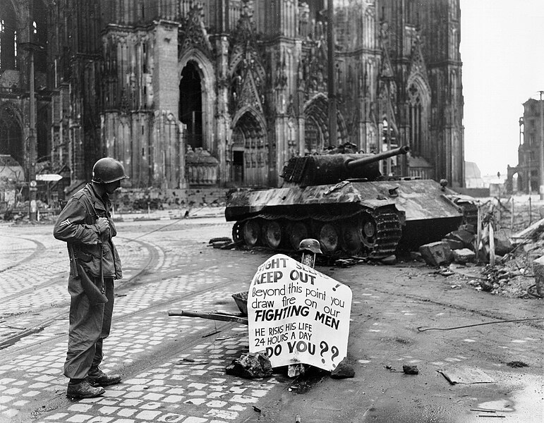
Esta imagen ha sido seleccionada como la Imagen del día el 30 de mayo de 2006. Fue descrita como sigue: Español: Un soldado americano lee un cartel ante la catedral de Colonia Otros idiomas:
Bahasa Melayu: Seorang Korporal dari 82nd Airborne Division membaca sebuah tanda amaran di jalan Cologne, Jerman, 4 April 1945. Català: Un soldat americá mira un cartell davant la catedral de Colonia Čeština: Voják čtoucí varování, Kolín nad Rýnem, Německo, 4. dubna 1945 Cymraeg: Milwr Americanaidd yn darllen arwydd o rybudd o yng Nghwlen (Cologne), yr Almaen, 4ydd o Ebrill 1945. Dansk: En amerikansk korporal i 82nd Airborne Division læsende et advarselsskilt i Köln, 4. april 1945. Deutsch: Ein Korporal der 82nd Airborne Division der U.S. Armee liest ein Warnschild auf der Straße; Köln, Deutschland, 4. April 1945. English: A Cpl. of 82nd Airborne Division reads a warning sign in the street Cologne, Germany, 4 April 1945. Español: Un soldado americano lee un cartel ante la catedral de Colonia Français : Un caporal de la U.S. 82nd Airborne Division (82e division aéroportée américaine) lisant un avertissement dans une rue de Cologne, Allemagne, le 4 avril 1945 Galego: Un cabo da 82 División Aerotransportada le un aviso nunha rúa de Colonia, Alemaña, 4 de abril de 1945. Lëtzebuergesch: E Kaperol vun der 82nd Airborne Division vun der U.S. Arméi liest e Warnschëld op enger Strooss zu Köln, Däitschland, 4. Abrëll 1945. Polski: Kapral 82 dywizji powietrzno-desantowej czyta napis ostrzegawczy na ulicy Kolonii. Niemcy, 4 kwietnia 1945. Português: Um soldado americano lendo um cartaz diante da catedral de Colônia, Alemanha em 4 de abril de 1945. Suomi: Alikersantti 82. maahanlaskudivisioonasta, tunnettu myös nimellä "All-Americas", lukee varoituskylttiä Kölnissä, Saksassa, 4. huhtikuuta 1945 Svenska: En amerikansk soldat läser en varningsskylt på en gata i Köln den 4 april 1945. العربية : كولن، ألمانيا، 4 أبريل 1945. |
This image was selected as picture of the day on Vietnamese Wikipedia.
|
Resumen[editar]
| Descripción |
English: Original caption: Cologne, Germany - Cpl. Luther E. Boger, Concord, N.C., skytrooper, reads a warning sign in the street. This street leads to the Rhine River and is under observation of the Germans who occupy a stronghold there. Cpl. Boger is with the 82nd Airborne Division. 4 April 1945. The German tank is burnt out and the torsion-bars have been destroyed by the immense heat of the fire.
|
| Fecha | Tomada el 4 de abril de 1945 |
| Fuente | US-Army history images (jpeg) |
| Autor | Post processing by User:W.wolny |
| Otras versiones |
.jpg)
| Posición de la cámara | | Ubicación de esta y otras imágenes en: OpenStreetMap |
|---|
Licencia[editar]
Esta imagen o archivo es un trabajo de un soldado o empleado del Ejército de los Estados Unidos de América, hecho en el curso de las funciones oficiales de la persona. Como un trabajo del gobierno federal de los Estados Unidos de América, la imagen o el archivo está en el dominio público.
|
 |
Historial del archivo
Haz clic sobre una fecha y hora para ver el archivo tal como apareció en ese momento.
| Fecha y hora | Miniatura | Dimensiones | Usuario | Comentario | |
|---|---|---|---|---|---|
| actual | 11:16 20 abr 2005 | | 2119 × 1649 (920 kB) | W.wolny (discusión | contribs.) |
No puedes sobrescribir este archivo.
Usos del archivo
Las siguientes páginas usan este archivo:
- 82nd Airborne Division
- Cologne
- Kölner Dom
- Panzerkampfwagen V
- User:Dschwen/FP2006
- User:KennethJorgensen/Favorites
- User:Thgoiter/Favourites
- Commons:Featured picture candidates/Image:Warning sign in cologne.jpg
- Commons:Featured picture candidates/Log/March 2006
- Commons:Featured pictures/Historical
- Commons:Featured pictures/chronological/2006-A
- Commons:Picture of the Year/2006/gallery
- Commons:Picture of the Year/2006/gallery0
- Commons:Picture of the Year/2006/gallery large
- Commons:Potd/2006-05 (fr)
- Commons:Potd/2006-05 (pl)
- Commons:Potd/2006-05 (pt)
- Commons:Potd/2006-05 (tr)
- Commons talk:Featured picture candidates/Archive candidate list
- File:Warning sign in cologne (cropped).jpg
- Template:Potd/2006-05
- Template:Potd/2006-05-30
- Template:Potd/2006-05-30 (ar)
- Template:Potd/2006-05-30 (ca)
- Template:Potd/2006-05-30 (cs)
- Template:Potd/2006-05-30 (cy)
- Template:Potd/2006-05-30 (da)
- Template:Potd/2006-05-30 (de)
- Template:Potd/2006-05-30 (en)
- Template:Potd/2006-05-30 (es)
- Template:Potd/2006-05-30 (fi)
- Template:Potd/2006-05-30 (fr)
- Template:Potd/2006-05-30 (gl)
- Template:Potd/2006-05-30 (ja)
- Template:Potd/2006-05-30 (lb)
- Template:Potd/2006-05-30 (ms)
- Template:Potd/2006-05-30 (pl)
- Template:Potd/2006-05-30 (pt)
- Template:Potd/2006-05-30 (ru)
- Template:Potd/2006-05-30 (sv)
- Template:Potd/2006-05-30 (zh-hans)
- Template:Potd/2006-05-30 (zh-hant)
Uso global del archivo
Las wikis siguientes utilizan este archivo:
- Uso en ar.wikipedia.org
- Uso en az.wikipedia.org
- Uso en bg.wikipedia.org
- Uso en ca.wikipedia.org
- Uso en cs.wikipedia.org
- Uso en da.wikipedia.org
- Uso en de.wikipedia.org
- Uso en de.wiktionary.org
- Uso en el.wikipedia.org
- Uso en en.wikipedia.org
- Uso en es.wikipedia.org
- Uso en eu.wikipedia.org
- Uso en fi.wikipedia.org
- Uso en fr.wikipedia.org
- Uso en fy.wikipedia.org
- Uso en he.wikipedia.org
- Uso en hu.wikipedia.org
- Uso en hy.wikipedia.org
- Uso en hyw.wikipedia.org
- Uso en ia.wikipedia.org
- Uso en id.wikipedia.org
- Uso en is.wikipedia.org
Ver más uso global de este archivo.
- Panzerkampfwagen V Ausführung A during World War II
- Warning signs in North Rhine-Westphalia
- Signs in Cologne
- 1945 in Cologne
- Historical images of Cologne
- 82nd Airborne Division
- Destroyed tanks
- Soldiers of the United States
- Thompson M1
- Black and white photographs of Cologne
- Black and white photographs of Germany in 1945
- Black and white photographs of men wearing military uniforms
- Black and white photographs of tanks in Germany
- Black and white photographs of World War II
- Boger (surname)
- Cologne Cathedral in World War II
- English-language signs in Germany
- Kölner Domplombe (Cologne Cathedral)
- Luther (given name)
- Male humans with helmets
- Men facing right and looking right
- Men of North Carolina
- Military men wearing boots
- Military people of North Carolina
- Military people of the United States in 1945
- Military people standing
- People of Concord, North Carolina
- People with signs in Germany
- Standing men in Germany
- 20th-century men of the United States