File:Washington Metro diagram sb.svg
跳至導覽
跳至搜尋

此 SVG 檔案的 PNG 預覽的大小:780 × 600 像素。 其他解析度:312 × 240 像素 | 625 × 480 像素 | 999 × 768 像素 | 1,280 × 984 像素 | 2,560 × 1,968 像素 | 1,600 × 1,230 像素。
原始檔案 (SVG 動畫檔案,表面大小:1,600 × 1,230 像素,檔案大小:58 KB)
注意:由於技術限制,此檔案縮圖無動畫效果。
說明
說明
添加單行說明來描述出檔案所代表的內容
infographic
| 描述 |
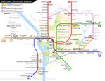
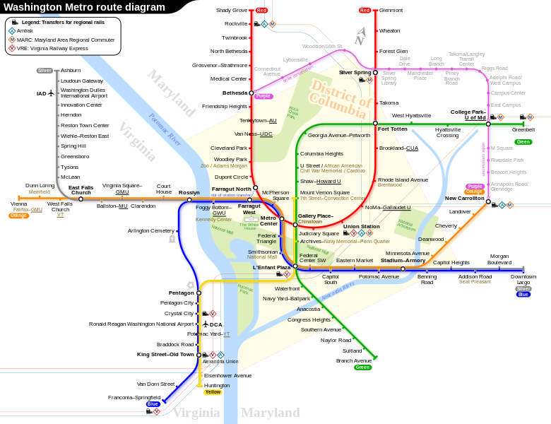
English: Route diagram of Washington Metro, including related routes under construction. (The Purple Line is not part of Washington Metro, but will connect to the Metro lines at the stations indicated.)
|
|||
| 日期 | 2015年11月27日, 13:36:31 (上傳日期) | |||
| 來源 | 自己的作品 | |||
| 作者 | Sameboat | |||
| 授權許可 (重用此檔案) |
我,本作品的著作權持有者,決定用以下授權條款發佈本作品: 此檔案採用創用CC 姓名標示-相同方式分享 4.0 國際授權條款。
|
|||
| 其他版本 |
|

Please do not replace the simplified code of this file with a version created with Inkscape or any other vector graphics editor

|
This SVG file contains embedded text that can be translated into your language, using any capable SVG editor, text editor or the SVG Translate tool. For more information see: About translating SVG files. |

|
本圖像是一個SVG動畫。本動畫使用SMIL語言。RSVG建立的,用於維基媒體網站的.png預覽圖像不能顯示動畫,而且圖像可能會殘缺不全或出現錯誤。要看到動畫,請開啟media:Washington Metro diagram sb.svg。這應該在現代瀏覽器或閱覽器中工作。最新版本的Chrome、Firefox、Microsoft Edge、Safari及Opera均支援基於SMIL的SVG動畫。
其他SVG動畫檔案可在Category:Animated SVG files找到。
|
檔案歷史
點選日期/時間以檢視該時間的檔案版本。
| 日期/時間 | 縮圖 | 尺寸 | 使用者 | 備註 | |
|---|---|---|---|---|---|
| 目前 | 2023年5月19日 (五) 13:27 | | 1,600 × 1,230(58 KB) | Sameboat(留言 | 貢獻) | |
| 2023年5月19日 (五) 13:27 |  | 1,600 × 1,230(58 KB) | Sameboat(留言 | 貢獻) | ||
| 2023年5月19日 (五) 13:25 |  | 1,600 × 1,230(58 KB) | Sameboat(留言 | 貢獻) | minor offset of station icons of College Park–U of Md | |
| 2023年5月19日 (五) 13:23 |  | 1,600 × 1,230(58 KB) | Sameboat(留言 | 貢獻) | fix yellow line and flip the Mount Vernon Square yellow station icon | |
| 2023年5月19日 (五) 12:58 |  | 1,600 × 1,230(58 KB) | Sameboat(留言 | 貢獻) | It's already done in the previous version. Reverted to version as of 02:20, 18 May 2023 (UTC) | |
| 2023年5月19日 (五) 08:15 |  | 1,600 × 1,230(57 KB) | Twotwofourtysix(留言 | 貢獻) | Update per request at Commons:Graphic Lab/Map workshop | |
| 2023年5月18日 (四) 02:20 |  | 1,600 × 1,230(58 KB) | Sameboat(留言 | 貢獻) | ||
| 2023年5月18日 (四) 02:16 |  | 1,600 × 1,230(58 KB) | Sameboat(留言 | 貢獻) | ||
| 2023年5月18日 (四) 01:50 |  | 1,600 × 1,230(58 KB) | Sameboat(留言 | 貢獻) | + Potomac Yard–VT station | |
| 2022年11月15日 (二) 00:11 |  | 1,600 × 1,230(58 KB) | PlanetJuice(留言 | 貢獻) | Add parking to Silver extension, add station name changes from 11 Sept 2022 |
無法覆蓋此檔案。
檔案用途
下列66個頁面有用到此檔案:
- Washington Metro
- User:Chumwa/OgreBot/Potential transport maps/2016 March 11-20
- User:Chumwa/OgreBot/Potential transport maps/2016 November 11-20
- User:Chumwa/OgreBot/Potential transport maps/2017 February 19-28
- User:Chumwa/OgreBot/Potential transport maps/2017 January 1-10
- User:Chumwa/OgreBot/Potential transport maps/2017 January 11-20
- User:Chumwa/OgreBot/Potential transport maps/2017 June 21-30
- User:Chumwa/OgreBot/Potential transport maps/2017 September 1-10
- User:Chumwa/OgreBot/Potential transport maps/2018 July 11-20
- User:Chumwa/OgreBot/Potential transport maps/2018 March 1-10
- User:Chumwa/OgreBot/Potential transport maps/2020 January 1-10
- User:Chumwa/OgreBot/Public transport information/2015 December 1-10
- User:Chumwa/OgreBot/Public transport information/2015 December 11-20
- User:Chumwa/OgreBot/Public transport information/2015 November 21-30
- User:Chumwa/OgreBot/Public transport information/2016 March 11-20
- User:Chumwa/OgreBot/Public transport information/2016 March 21-31
- User:Chumwa/OgreBot/Public transport information/2016 November 11-20
- User:Chumwa/OgreBot/Public transport information/2017 February 19-28
- User:Chumwa/OgreBot/Public transport information/2017 January 1-10
- User:Chumwa/OgreBot/Public transport information/2017 January 11-20
- User:Chumwa/OgreBot/Public transport information/2017 June 21-30
- User:Chumwa/OgreBot/Public transport information/2017 September 1-10
- User:Chumwa/OgreBot/Public transport information/2018 July 11-20
- User:Chumwa/OgreBot/Public transport information/2018 March 1-10
- User:Chumwa/OgreBot/Public transport information/2020 December 21-31
- User:Chumwa/OgreBot/Public transport information/2020 January 1-10
- User:Chumwa/OgreBot/Public transport information/2022 November 11-20
- User:Chumwa/OgreBot/Public transport information/2023 May 11-20
- User:Chumwa/OgreBot/Transport Maps/2015 December 1-10
- User:Chumwa/OgreBot/Transport Maps/2015 December 11-20
- User:Chumwa/OgreBot/Transport Maps/2015 November 21-30
- User:Chumwa/OgreBot/Transport Maps/2016 March 11-20
- User:Chumwa/OgreBot/Transport Maps/2016 March 21-31
- User:Chumwa/OgreBot/Transport Maps/2016 November 11-20
- User:Chumwa/OgreBot/Transport Maps/2017 February 19-28
- User:Chumwa/OgreBot/Transport Maps/2017 January 1-10
- User:Chumwa/OgreBot/Transport Maps/2017 January 11-20
- User:Chumwa/OgreBot/Transport Maps/2017 June 21-30
- User:Chumwa/OgreBot/Transport Maps/2017 September 1-10
- User:Chumwa/OgreBot/Transport Maps/2018 July 11-20
- User:Chumwa/OgreBot/Transport Maps/2018 March 1-10
- User:Chumwa/OgreBot/Transport Maps/2020 December 21-31
- User:Chumwa/OgreBot/Transport Maps/2020 January 1-10
- User:Chumwa/OgreBot/Transport Maps/2022 November 11-20
- User:Chumwa/OgreBot/Transport Maps/2023 May 11-20
- User:Chumwa/OgreBot/Travel and communication maps/2016 March 11-20
- User:Chumwa/OgreBot/Travel and communication maps/2016 March 21-31
- User:Chumwa/OgreBot/Travel and communication maps/2016 November 11-20
- User:Chumwa/OgreBot/Travel and communication maps/2017 February 19-28
- User:Chumwa/OgreBot/Travel and communication maps/2017 January 1-10
- User:Chumwa/OgreBot/Travel and communication maps/2017 January 11-20
- User:Chumwa/OgreBot/Travel and communication maps/2017 June 21-30
- User:Chumwa/OgreBot/Travel and communication maps/2017 September 1-10
- User:Chumwa/OgreBot/Travel and communication maps/2018 July 11-20
- User:Chumwa/OgreBot/Travel and communication maps/2018 March 1-10
- User:Chumwa/OgreBot/Travel and communication maps/2020 December 21-31
- User:Chumwa/OgreBot/Travel and communication maps/2020 January 1-10
- User:Chumwa/OgreBot/Travel and communication maps/2022 November 11-20
- User:GeorgR (de)/Rail Transport in the US/2022 November
- User:GeorgR (de)/Rail Transport in the US/2023 May
- User:Sameboat
- Commons:Graphic Lab/Map workshop/Archive/2023
- File:Washington Metro diagram sb.pdf
- File:Washington Metro diagram sb.svg
- Category:Washington Metro
- Category:Washington Metro stations
全域檔案使用狀況
以下其他 wiki 使用了這個檔案:
- bg.wikipedia.org 的使用狀況
- bn.wikipedia.org 的使用狀況
- ca.wikipedia.org 的使用狀況
- cs.wikipedia.org 的使用狀況
- da.wikipedia.org 的使用狀況
- de.wikipedia.org 的使用狀況
- de.wikivoyage.org 的使用狀況
- en.wikipedia.org 的使用狀況
- en.wikivoyage.org 的使用狀況
- eo.wikipedia.org 的使用狀況
- es.wikipedia.org 的使用狀況
- eu.wikipedia.org 的使用狀況
- fa.wikipedia.org 的使用狀況
- fi.wikipedia.org 的使用狀況
- fi.wikivoyage.org 的使用狀況
- fr.wikipedia.org 的使用狀況
- Métro de Washington
- Dupont Circle (métro de Washington)
- Red Line du métro de Washington
- Blue Line du métro de Washington
- Orange Line du métro de Washington
- Yellow Line du métro de Washington
- Green Line du métro de Washington
- Silver Line du métro de Washington
- Shady Grove (métro de Washington)
- Glenmont (métro de Washington)
- Metro Center (métro de Washington)
- Farragut North (métro de Washington)
- Gallery Place-Chinatown (métro de Washington)
- Judiciary Square (métro de Washington)
檢視此檔案的更多全域使用狀況。