File:World map of prehistoric human migrations.jpg
Fichier d’origine (889 × 635 pixels, taille du fichier : 274 kio, type MIME : image/jpeg)
Légendes
Légendes

|
Cette image (de type biogeographical map) devrait être recréée dans un format vectoriel, en tant que fichier SVG. Cela offrirait plusieurs avantages : voir Commons:Media for cleanup pour plus d'informations. Si une version SVG de cette image est déjà disponible, merci de bien vouloir l'envoyer. Après cela, remplacez ce modèle par {{vector version available|nouveau nom d'image.svg}}.
|


Description
[modifier]
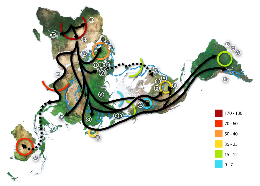
World map of human migrations, with the North Pole at center. Made in 2005.
Africa, harboring the start of the migration, is at the top left and South America at the far right. Migration patterns are based on studies of mitochondrial (matrilinear) DNA. Dashed lines are hypothetical migrations.
Numbers represent thousand years before present.
The blue line represents area covered in ice or tundra during the last great ice age.
The letters are the mitochondrial DNA haplogroups (pure motherly lineages); Haplogroups can be used to define genetic populations and are often geographically oriented. For example, the following are common divisions for mtDNA haplogroups:
- African: L, L1, L2, L3
- Near Eastern: J, N
- Southern European: J, K
- General European: H, V
- Northern European: T, U, X
- Asian: A, B, C, D, E, F, G (note: M is composed of C, D, E, and G)
- Native American: A, B, C, D, and sometimes X
- The letters I, J, K shown in Europe are apparently included by mistake, as they refer to Y-DNA haplogroups.
The dashed path for X, stopping in Iceland, gestures at the "Solutrean hypothesis", an idea discussed in the popular media at the time the map was made but mostly discredited since.
Data derivation
[modifier]
- Image:Northern icesheet hg.png shows the region that was covered by ice or tundra in the last ice age
- All migration data based on mitomap.
- Geographic data from File:Last glacial vegetation map.png
- and adding the following data File:Ice Age Temperature.png we get this interesting result File:Human-migration-temperature.jpg
Licenses
[modifier]

|
Vous avez la permission de copier, distribuer et modifier ce document selon les termes de la GNU Free Documentation License version 1.2 ou toute version ultérieure publiée par la Free Software Foundation, sans sections inaltérables, sans texte de première page de couverture et sans texte de dernière page de couverture. Un exemplaire de la licence est inclus dans la section intitulée GNU Free Documentation License. |
| Ce fichier est disponible selon les termes de la licence Creative Commons Attribution – Partage dans les Mêmes Conditions 3.0 (non transposée). | ||
| ||
| Ce bandeau de licence a été ajouté à ce fichier dans le cadre de la procédure de mise à jour des licences des images sous GFDL. |
- Vous êtes libre :
- de partager – de copier, distribuer et transmettre cette œuvre
- d’adapter – de modifier cette œuvre
- Sous les conditions suivantes :
- paternité – Vous devez donner les informations appropriées concernant l'auteur, fournir un lien vers la licence et indiquer si des modifications ont été faites. Vous pouvez faire cela par tout moyen raisonnable, mais en aucune façon suggérant que l’auteur vous soutient ou approuve l’utilisation que vous en faites.
- partage à l’identique – Si vous modifiez, transformez, ou vous basez sur cette œuvre, vous devez distribuer votre contribution sous la même licence ou une licence compatible avec celle de l’original.
Historique du fichier
Cliquer sur une date et heure pour voir le fichier tel qu'il était à ce moment-là.
| Date et heure | Vignette | Dimensions | Utilisateur | Commentaire | |
|---|---|---|---|---|---|
| actuel | 2 juillet 2015 à 01:54 | | 889 × 635 (274 kio) | Chronus (d | contributions) | Reverted to version as of 03:10, 22 May 2012 |
| 24 juin 2015 à 18:00 |  | 632 × 889 (295 kio) | SteinsplitterBot (d | contributions) | Bot: Image rotated by 90° | |
| 22 mai 2012 à 03:10 |  | 889 × 635 (274 kio) | 84user (d | contributions) | Reverted to version as of 19:10, 12 August 2005 | |
| 20 mai 2012 à 23:30 |  | 632 × 889 (295 kio) | Rotatebot (d | contributions) | Bot: Image rotated by 90° | |
| 12 août 2005 à 19:10 |  | 889 × 635 (274 kio) | Avsa (d | contributions) | ||
| 5 août 2005 à 21:05 |  | 536 × 380 (80 kio) | Stevertigo (usurped) (d | contributions) | reupload with similar changes, but without compression/artifacts | |
| 5 août 2005 à 21:00 |  | 536 × 380 (30 kio) | Stevertigo (usurped) (d | contributions) | altered brightness contrast - black/brown blending was distracting in last version | |
| 17 juillet 2005 à 20:30 |  | 536 × 380 (110 kio) | Avsa (d | contributions) | ||
| 16 juillet 2005 à 18:08 |  | 745 × 380 (99 kio) | Avsa (d | contributions) | Map of human races migration, according to the mithocondrial dna. All data based on mitomap http://www.mitomap.org/WorldMigrations.pdf I ignored all data I could not understand (for example a dotted line, the +/- and the letters). If someone explains to | |
| 16 juillet 2005 à 18:03 |  | 745 × 380 (99 kio) | Avsa (d | contributions) | Map of human races migration, according to the mithocondrial dna. All data based on mitomap http://www.mitomap.org/WorldMigrations.pdf I ignored all data I could not understand (for example a dotted line, the +/- and the letters). If someone explains to |
Vous ne pouvez pas remplacer ce fichier.
Utilisations locales du fichier
Les 24 pages suivantes utilisent ce fichier :
- Atlas of Africa
- Atlas of world history
- Homo sapiens
- Top 200 JPG images that should use vector graphics
- Top 200 biology images that should use vector graphics
- Top 200 map images that should use vector graphics
- User:Joaquín Salido Bello
- User:Zeupar
- Commons:Featured picture candidates/Image:Map-of-human-migrations.jpg
- Commons:Featured picture candidates/Log/December 2005
- Commons:Village pump/Archive/2016/10
- Commons:Wikimania Media Competition 2005/Maps and Diagrams
- File:Early migrations mercator.svg
- File:Map-of-human-migrations.jpg (redirection de fichier)
- Commons:Wikimania Media Competition 2005/Maps and Diagrams
- Commons:Featured picture candidates/Log/December 2005
- Commons:Featured picture candidates/Image:Map-of-human-migrations.jpg
- Atlas of world history
- File talk:Human-migration-temperature.jpg
- Commons:Village pump/Archive/2016/10
- User:Joaquín Salido Bello
- File:Early migrations mercator.svg
- File talk:Human-migration-temperature.jpg
- Category:Out of Africa
Utilisations du fichier sur d’autres wikis
Les autres wikis suivants utilisent ce fichier :
- Utilisation sur af.wikipedia.org
- Utilisation sur ar.wikipedia.org
- Utilisation sur ba.wikipedia.org
- Utilisation sur bn.wikipedia.org
- Utilisation sur bs.wikipedia.org
- Utilisation sur bxr.wikipedia.org
- Utilisation sur ca.wikipedia.org
- Utilisation sur cs.wikipedia.org
- Utilisation sur da.wikipedia.org
- Utilisation sur de.wikipedia.org
- Utilisation sur de.wikinews.org
- Utilisation sur de.wiktionary.org
- Utilisation sur en.wikipedia.org
- Human evolution
- Wildlife
- Dymaxion map
- Talk:Human migration
- User:Avsa
- User talk:Truthteller
- Wikipedia:Reference desk/Archives/July 2005 II
- Genealogical DNA test
- User talk:Brian0918/Archive 07
- Haplogroup
- Talk:Human/Archive 16
- Haplogroup N (mtDNA)
- Haplogroup A (mtDNA)
- Haplogroup C (mtDNA)
- Haplogroup L3
- Human genetic variation
- Haplogroup Y
- Talk:Black people/Archive 11
- Portal:Maps/Maps/Thematic
- Portal:Maps/Maps/Thematic/1
Voir davantage sur l’utilisation globale de ce fichier.
- Haplogroup J (mtDNA)
- Haplogroup H (mtDNA)
- Human mtDNA haplogroups
- Out of Africa maps
- Homo sapiens distribution maps
- Pleistocene
- Holocene life
- Maps with Fuller projection
- Haplogroup T (mtDNA)
- Haplogroup H (mtDNA) in Poland
- Phylogenetic tree of human populations
- Haplogroup L3 (mtDNA)
- Genetic studies on Oceanian populations