File:World map of prehistoric human migrations.jpg
Изворна податотека (889 × 635 пиксели, големина: 274 КБ, MIME-тип: image/jpeg)
Описи
Описи

|
Оваа слика (или сите слики од оваа страница/категорија) би требало бидат се преработи користејќи векторска графика со формат SVG. Тоа нуди неколку предности; видете „Податотеки за расчистување“ за повеќе информации. Доколку оваа слика веќе постои во SVG формат, тогаш подигнете ја. Откако ќе го направите тоа, заменете ја оваа предлошка со предлошката {{Vector version available|име на новата податотека.svg}}.
|


Опис[уреди]
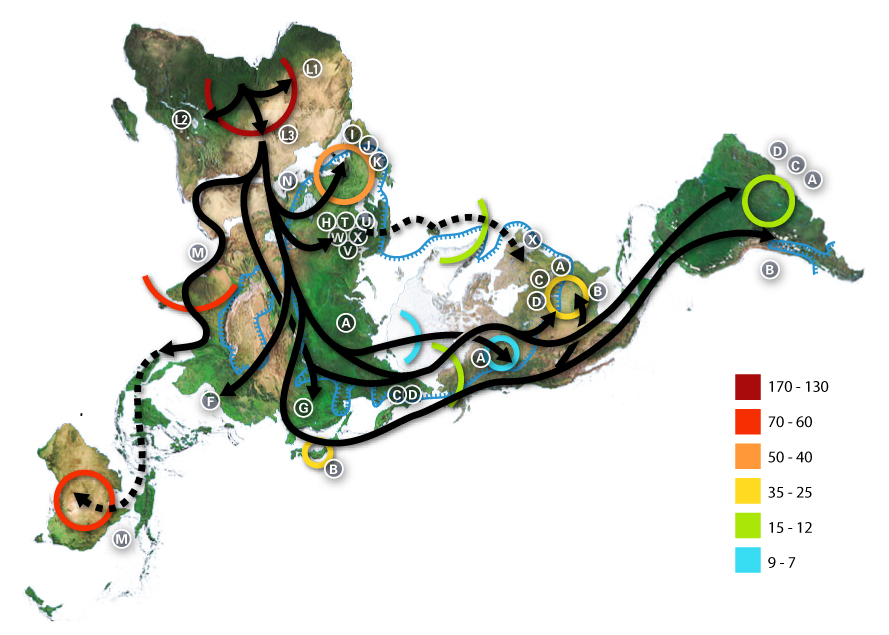
World map of human migrations, with the North Pole at center. Made in 2005.
Africa, harboring the start of the migration, is at the top left and South America at the far right. Migration patterns are based on studies of mitochondrial (matrilinear) DNA. Dashed lines are hypothetical migrations.
Numbers represent thousand years before present.
The blue line represents area covered in ice or tundra during the last great ice age.
The letters are the mitochondrial DNA haplogroups (pure motherly lineages); Haplogroups can be used to define genetic populations and are often geographically oriented. For example, the following are common divisions for mtDNA haplogroups:
- African: L, L1, L2, L3
- Near Eastern: J, N
- Southern European: J, K
- General European: H, V
- Northern European: T, U, X
- Asian: A, B, C, D, E, F, G (note: M is composed of C, D, E, and G)
- Native American: A, B, C, D, and sometimes X
- The letters I, J, K shown in Europe are apparently included by mistake, as they refer to Y-DNA haplogroups.
The dashed path for X, stopping in Iceland, gestures at the "Solutrean hypothesis", an idea discussed in the popular media at the time the map was made but mostly discredited since.
Data derivation[уреди]
- Image:Northern icesheet hg.png shows the region that was covered by ice or tundra in the last ice age
- All migration data based on mitomap.
- Geographic data from File:Last glacial vegetation map.png
- and adding the following data File:Ice Age Temperature.png we get this interesting result File:Human-migration-temperature.jpg
Licenses[уреди]

|
Се дава дозвола за умножување, распространување и/или менување на овој документ под условите на ГНУ-овата лиценца за слободна документација, само Верзија 1.2 или било која понова верзија објавена од Фондацијата за слободна програмска опрема; без неменливи делови и без текстови на предни и задни корици. Примерок од лиценцата ќе најдете во делот наречен ГНУ-ова лиценца за слободна докуменација. |
| Оваа податотека е под лиценцата Криејтив комонс Наведи извор-Сподели под исти услови 3.0 Нелокализирана. | ||
| ||
| Оваа ознака за лиценца е додадена на податотекава како дел од подновата на лиценците на ГЛСД. |
- Можете:
- да споделите – да го умножувате, распространувате и емитувате делото
- да преработувате – да преработувате
- Под следните услови:
- наведи извор – Ќе мора да дадете прикладен припис, да ставите врска до лиценцата и да укажете дали има направено промени. Ова може да биде направено на било кој разумен начин, но без да оддава впечаток дека лиценцодавецот стои зад Вас и Вашата употреба.
- сподели под исти услови – Ако го измените или преобразите делото, или пак ако основате друго дело на него, добиеното дело (придонесот) морате да го распространувате (објавувате) само под истата или складна лиценца на изворната.
Историја на податотеката
Стиснете на датум/време за да ја видите податотеката како изгледала тогаш.
| Датум/време | Минијатура | Димензии | Корисник | Коментар | |
|---|---|---|---|---|---|
| тековна | 01:54, 2 јули 2015 | | 889 × 635 (274 КБ) | Chronus (разговор | придонеси) | Reverted to version as of 03:10, 22 May 2012 |
| 18:00, 24 јуни 2015 |  | 632 × 889 (295 КБ) | SteinsplitterBot (разговор | придонеси) | Bot: Image rotated by 90° | |
| 03:10, 22 мај 2012 |  | 889 × 635 (274 КБ) | 84user (разговор | придонеси) | Reverted to version as of 19:10, 12 August 2005 | |
| 23:30, 20 мај 2012 |  | 632 × 889 (295 КБ) | Rotatebot (разговор | придонеси) | Bot: Image rotated by 90° | |
| 19:10, 12 август 2005 |  | 889 × 635 (274 КБ) | Avsa (разговор | придонеси) | ||
| 21:05, 5 август 2005 |  | 536 × 380 (80 КБ) | Stevertigo (usurped) (разговор | придонеси) | reupload with similar changes, but without compression/artifacts | |
| 21:00, 5 август 2005 |  | 536 × 380 (30 КБ) | Stevertigo (usurped) (разговор | придонеси) | altered brightness contrast - black/brown blending was distracting in last version | |
| 20:30, 17 јули 2005 |  | 536 × 380 (110 КБ) | Avsa (разговор | придонеси) | ||
| 18:08, 16 јули 2005 |  | 745 × 380 (99 КБ) | Avsa (разговор | придонеси) | Map of human races migration, according to the mithocondrial dna. All data based on mitomap http://www.mitomap.org/WorldMigrations.pdf I ignored all data I could not understand (for example a dotted line, the +/- and the letters). If someone explains to | |
| 18:03, 16 јули 2005 |  | 745 × 380 (99 КБ) | Avsa (разговор | придонеси) | Map of human races migration, according to the mithocondrial dna. All data based on mitomap http://www.mitomap.org/WorldMigrations.pdf I ignored all data I could not understand (for example a dotted line, the +/- and the letters). If someone explains to |
Не можете да презапишете врз податотекава.
Употреба на податотеката
Податотекава се користи во следниве 24 страници:
- Atlas of Africa
- Atlas of world history
- Homo sapiens
- Top 200 JPG images that should use vector graphics
- Top 200 biology images that should use vector graphics
- Top 200 map images that should use vector graphics
- User:Joaquín Salido Bello
- User:Zeupar
- Commons:Featured picture candidates/Image:Map-of-human-migrations.jpg
- Commons:Featured picture candidates/Log/December 2005
- Commons:Village pump/Archive/2016/10
- Commons:Wikimania Media Competition 2005/Maps and Diagrams
- File:Early migrations mercator.svg
- File:Map-of-human-migrations.jpg (пренасочување)
- Commons:Wikimania Media Competition 2005/Maps and Diagrams
- Commons:Featured picture candidates/Log/December 2005
- Commons:Featured picture candidates/Image:Map-of-human-migrations.jpg
- Atlas of world history
- File talk:Human-migration-temperature.jpg
- Commons:Village pump/Archive/2016/10
- User:Joaquín Salido Bello
- File:Early migrations mercator.svg
- File talk:Human-migration-temperature.jpg
- Category:Out of Africa
Глобална употреба на податотеката
Оваа податотека ја користат и следниве викија:
- Употреба на af.wikipedia.org
- Употреба на ar.wikipedia.org
- Употреба на ba.wikipedia.org
- Употреба на bn.wikipedia.org
- Употреба на bs.wikipedia.org
- Употреба на bxr.wikipedia.org
- Употреба на ca.wikipedia.org
- Употреба на cs.wikipedia.org
- Употреба на da.wikipedia.org
- Употреба на de.wikipedia.org
- Употреба на de.wikinews.org
- Употреба на de.wiktionary.org
- Употреба на en.wikipedia.org
- Human evolution
- Wildlife
- Dymaxion map
- Talk:Human migration
- User:Avsa
- User talk:Truthteller
- Wikipedia:Reference desk/Archives/July 2005 II
- Genealogical DNA test
- User talk:Brian0918/Archive 07
- Haplogroup
- Talk:Human/Archive 16
- Haplogroup N (mtDNA)
- Haplogroup A (mtDNA)
- Haplogroup C (mtDNA)
- Haplogroup L3
- Human genetic variation
- Haplogroup Y
- Talk:Black people/Archive 11
- Portal:Maps/Maps/Thematic
- Portal:Maps/Maps/Thematic/1
Погледајте ја останатата глобална употреба на податотекава.
- Haplogroup J (mtDNA)
- Haplogroup H (mtDNA)
- Human mtDNA haplogroups
- Out of Africa maps
- Homo sapiens distribution maps
- Pleistocene
- Holocene life
- Maps with Fuller projection
- Haplogroup T (mtDNA)
- Haplogroup H (mtDNA) in Poland
- Phylogenetic tree of human populations
- Haplogroup L3 (mtDNA)
- Genetic studies on Oceanian populations