File:Europe in 1923.jpg

Tập tin gốc (7.097×5.456 điểm ảnh, kích thước tập tin: 6,97 MB, kiểu MIME: image/jpeg)
Chú thích
Chú thích
Miêu tả[sửa]
| Lời miêu tả |
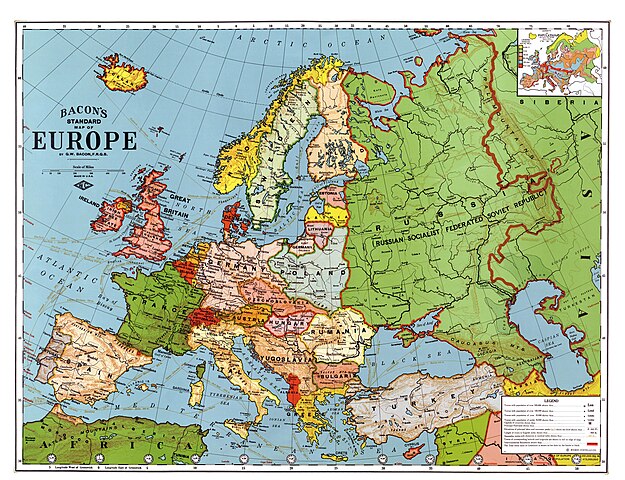
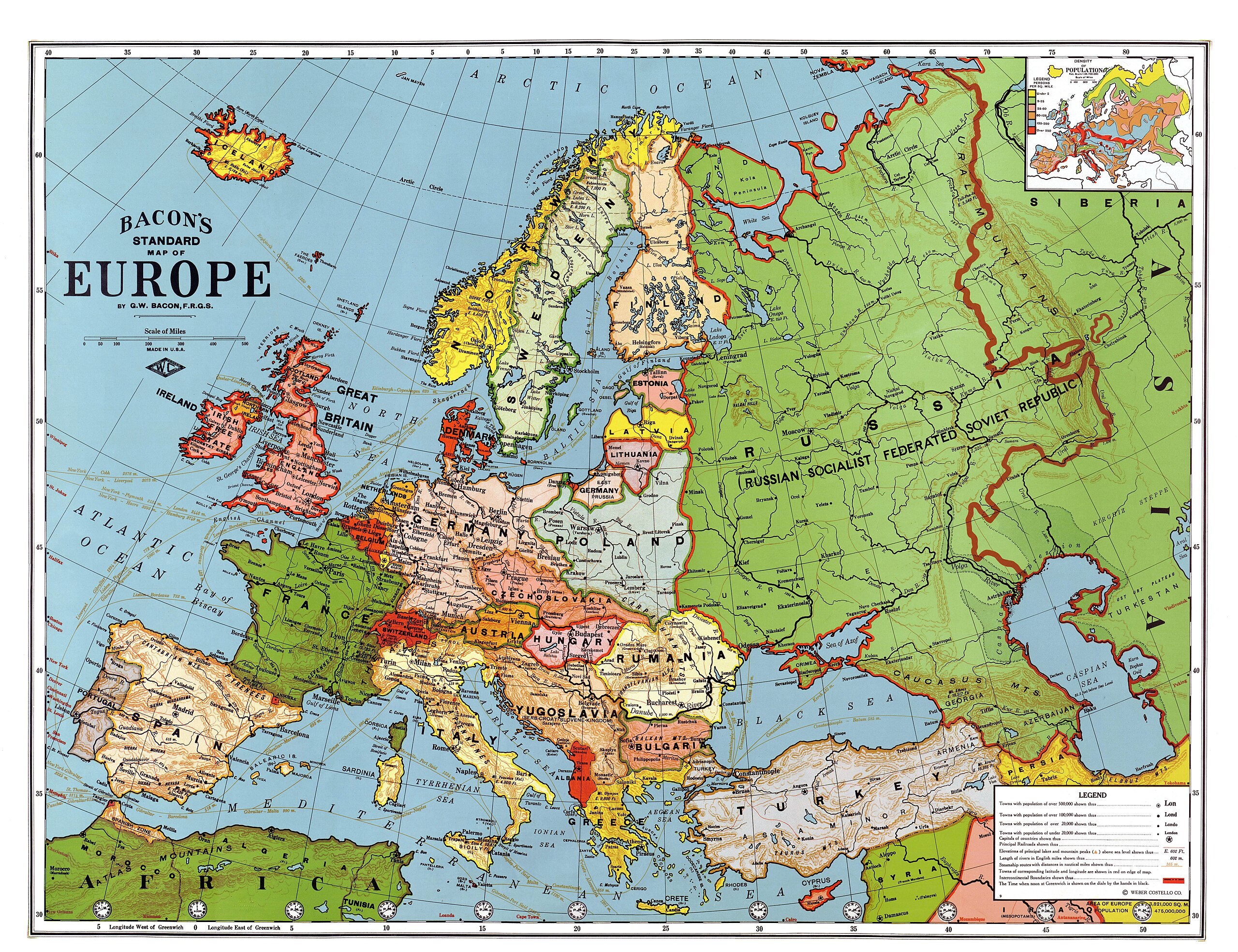
English: Bacon's standard map of Europe, 1923. Relief shown by hachures and spot heights. Shows steamship routes and time zones. Published by Weber Costello Co., 84 x 111 cm. Scale 1:5,500,000 (W 52°--E 80°/N 60°--N 30°).
Français : Carte "standard" de l'Europe au 1/5 500 000, par Bacon, 1923. Les reliefs sont donnés par des hachures et des indications de certaines altitudes. Les principales routes maritimes sont indiquées, ainsi que les fuseaŭx horaires. Publié par la compagnie Weber Costello, 84 x 111 cm.
Italiano: Carta geografica generale dell'Europa in lingua inglese (84 x 111 cm, scala 1:5 500 000), realizzata da G. W. Bacon e pubblicata da Weber Costello Co. nel 1923
Polski: Mapa Europy w skali 1:5500000 wydawnictwa Weber Costello Co. Uwzględnia granice z 1923 r. oraz m.in. szlaki morskie i strefy czasowe.
Türkçe: 1923 yılındaki ülke sınırlarını gösteren Avrupa haritası. Yükseltiler tarama çizgiler ve belli noktaların yükseklikleri ile belli edilmiştir. Saat dilimleri ve gemi yolları da gösterilmiştir. |
||
| Ngày | sau 1924 | ||
| Nguồn gốc |
|
||
| Sáng tác |
Bacon, George Washington (1830-1921) |
||
| Georeferencing | If inappropriate please set warp_status = skip to hide. | ||
| Phiên bản khác |


| Đây là một ảnh đã được chỉnh sửa, có nghĩa là nó đã được chỉnh sửa kỹ thuật số so với phiên bản gốc. Các chỉnh sửa: Contrast enhanced, colors corrected, halves united. Các chỉnh sửa được thực hiện bởi Alex:D. Có thẩy tìm thấy bản gốc tại đây.
|
|

Bức hình này đã được chọn làm hình ảnh của ngày trên Wikimedia Commons vào ngày 27 tháng 5 năm 2010. Dưới đây là lời mô tả: English: George Washington Bacon's standard map of Europe, 1923. Relief shown by hachures and spot heights. Shows steamship routes and time zones. Published by Weber Costello Co., 84 × 111 cm. Scale 1:5,500,000 (W 52°--E 80°/N 60°--N 30°). Các ngôn ngữ khác:
Čeština: Standardní mapa Evropy od George Washingtona Bacona z roku 1923; reliéf je značen šrafurou a kótami, vyznačeny jsou tratě parníků a časová pásma; měřítko 1 : 5 500 000, 84 × 111 cm Dansk: George Washington Bacons standardkort over Europa fra 1923. Topografien er vist med skraveringer, og punkter viser bjergtoppe. Kortet viser også skibsruter og tidszoner. Udgivet af Weber Costello Co, 88 × 111 cm. Målestok 1:5.500.000 (52°V - 80°Ø / 60°N - 30°N). Deutsch: George Washington Bacons Standardkarte von Europa von 1923. Die Topografie wird durch Schraffuren und Punkthöhen dargestellt. Ebenso sind Dampferrouten und Zeitzonen dargestellt. Veröffentlicht durch Weber Costello Co., 84 × 111 cm. Maßstab 1:5,500,000 (W 52°--E 80°/N 60°--N 30°). English: George Washington Bacon's standard map of Europe, 1923. Relief shown by hachures and spot heights. Shows steamship routes and time zones. Published by Weber Costello Co., 84 × 111 cm. Scale 1:5,500,000 (W 52°--E 80°/N 60°--N 30°). Español: Mapa estándar de Europa de George Washington Bacon, 1923. El relieve se muestra con líneas de sombra y puntos de altura. Incluye rutas de barcos a vapor y zonas horarias. Publicado por Weber Costello Co., 84×111 cm. Escala 1:5.500.000 (52° O–80° E/60° N–30° N). Français : Carte "standard" de l'Europe au 1/5 500 000, par Bacon, 1923. Les reliefs sont donnés par des hachures et des indications de certaines altitudes. Les principales routes maritimes sont indiquées, ainsi que les fuseaux horaires. Publié par la compagnie Weber Costello, 84 x 111 cm. Italiano: Carta geografica generale dell'Europa in lingua inglese (84 x 111 cm, scala 1:5 500 000), realizzata da G. W. Bacon e pubblicata da Weber Costello Co. nel 1923 Magyar: Európa-térkép 1923-ból, időzónákkal és hajóutakkal Nederlands: Standaardkaart van Europa uit 1923 van de Britse uitgever George Washington Bacon (1830-1922). De topografie wordt weergegeven door arceringen en hoogtepunten. Ook zijn stoombootroutes en tijdzones afgebeeld. Uitgegeven door Weber Costello Co. Afmeting: 84 × 111 cm. Schaal 1:5.500.000 (W 52° - E 80°/N 60° - N 30°). Português: Mapa da Europa publicado em 1923. Беларуская (тарашкевіца): Агульная мапа Эўропы Джорджа Вашынгтона Бэкана 1923 году. Выдадзена Weber Costello Co., 84 × 111 см. Маштаб 1:5 500 000 (З 52°—У 80°/П 60°—П 30°). Македонски: Бејконова стандардна карта на Европа на (1923). Релјефот е изразен со сенчање и коти. Прикажани се парабродски маршрути и часовни зони. Издавач: Weber Costello Co., 84 × 111 cm. Размер: 1:5.500.000 (З 52°--И 80°/С 60°--С 30°). Українська: Карта Європи 1923 року англійського видавця книг і мап Джорджа Вашінгтона Бейкена. Зображено рельєф, пароплавні маршрути, часові пояси. Надруковано Weber Costello Co., 84 × 111 см. Масштаб 1:5 500 000 (З 52°— С 80°/П 60° — П 30°). বাংলা : ১৯২৩ সালে জর্জ ওয়াশিংটন বেকন কর্তৃক অঙ্কিত ইউরোপের মানচিত্র। কোনো স্থানের উচ্চতা প্রদর্শিত হয়েছে, সেই সাথে বাষ্পীয় ইঞ্জিন চালিত জাহাজের চলাচলের পথ ও সময়স্থানও সূচিত হয়েছে। এটি প্রকাশ করেছিলো ওয়েবার ক্যাসটেল্লো কোম্পানি। প্রকাশের সময় এর আকৃতি ছিলো ৮৪ × ১১১ সেন্টিমিটার। স্কেল ১:৫,৫০০,০০০ (প্রদর্শিত স্থান: ৫২° পশ্চিম - ৮০° পূর্ব ও ৬০° উত্তর থেকে ৩০° উত্তর)। 한국어: 1923년의 유럽 지도. 日本語: 「ベーコンの標準ヨーロッパ地図」縮尺 1 : 5,500,000。1923年アメリカ製。 中文: 1923年版本的欧洲地图,比例尺为1:5,500,000,尺寸为84 x 111 cm 中文(繁體): 1923年版本的歐洲地圖,比例尺為1:5,500,000,尺寸為84 x 111 cm。 |
Giấy phép[sửa]
|
Tác phẩm này thuộc về phạm vi công cộng tại quốc gia gốc và các quốc gia và vùng lãnh thổ có thời hạn bản quyền là cuộc đời tác giả cộng thêm 70 trở xuống.
| |
| Tập tin này đã được đánh dấu là không bị hạn chế dưới luật bản quyền, kể cả tất cả những quyền liên quan và lần cận. | |
Tập tin này thuộc phạm vi công cộng tại Hoa Kỳ vì đây là một tác phẩm Hoa Kỳ đã hết hạn bảo hộ bản quyền vì nó được xuất bản trước ngày 1 tháng 1 năm 1929. Đọc trang này để biết thêm thông tin chi tiết.
|
 | |
 |
Hình này có thể không thuộc phạm vi công cộng ở ngoài Hoa Kỳ. Các nước Canada, Trung Quốc đại lục (không tính Hồng Kông và Macao), Đức, Mexico, cũng như Thụy Sĩ không áp dụng quy tắc thời hạn ngắn hơn cho các tác phẩm Hoa Kỳ. Do đó, thông tin về tên tác giả và năm phát hành tác phẩm là không thể thiếu. Bạn có thể đọc Wikipedia:Public domain và Wikipedia:Copyrights (tiếng Anh) để biết thêm thông tin chi tiết.
|
_en.png)
.png)
.jpg)
Lịch sử tập tin
Nhấn vào ngày/giờ để xem nội dung tập tin tại thời điểm đó.
| Ngày/Giờ | Hình xem trước | Kích cỡ | Thành viên | Miêu tả | |
|---|---|---|---|---|---|
| hiện tại | 14:15, ngày 25 tháng 1 năm 2013 | | 7.097×5.456 (6,97 MB) | Slick-o-bot (thảo luận | đóng góp) | Bot: convert to a non-interlaced jpeg (see bug #17645) |
| 06:58, ngày 1 tháng 5 năm 2009 |  | 7.097×5.456 (6,54 MB) | Alex:D (thảo luận | đóng góp) | {{Information |Description= {{en|Bacon's standard map of Europe, 1923. Published by Weber Costello Co., 84 x 111 cm. Relief shown by hachures and spot heights. Shows steamship routes and time zones. Scale 1:5,500,000 (W 52°--E 80°/N 60°--N 30°).} |
Bạn không được phép ghi đè tập tin này.
Trang sử dụng tập tin
55 trang sau sử dụng tập tin này:
- User:Fæ/LOC maps/wikimedia usage
- User:Platonides/POTD
- User talk:Alex:D/3
- Commons:Featured picture candidates/File:Map of Europe, 1921.jpg
- Commons:Featured picture candidates/Log/May 2009
- Commons:Featured pictures/Non-photographic media/Maps
- Commons:Featured pictures/chronological/2009-A
- Commons:Picture of the Year/2009/Galleries/2009-A
- Commons:Picture of the Year/2009/Galleries/All
- Commons:Picture of the Year/2009/Galleries/Diagrams
- Commons:Picture of the Year/2009/Galleries/Index/6
- Commons:Picture of the Year/2009/Galleries/Index/Diagrams
- Commons:Picture of the Year/2009/Galleries/Table/200905
- Commons:Picture of the Year/2009/R1/File:Map of Europe, 1923.jpg
- Commons:Picture of the Year/2009/Results/R1/ALL/Table
- Commons:Picture of the Year/2009/Results/R1/Diagrams
- Commons:Picture of the Year/2009/Results/R1/Diagrams/Table
- Commons:Potd/2010-05 (da)
- Commons:Potd/2010-05 (de)
- Commons:Potd/2010-05 (nl)
- Commons:Potd/2010-05 (pt)
- File:Ildefonso Puigdengolas (Albero y Segovia 21-07-1936) en Alcalá de Henares.png
- File:Lithuania, Latvia and Estonia (1923).JPG
- File:Map of Density of Population of Europe, 1923.jpg
- File:Map of Europe, 1923.jpg (tập tin đổi hướng)
- Commons:Picture of the Year/2009/Galleries/Diagrams
- Commons:Picture of the Year/2009/Galleries/All
- Commons:Picture of the Year/2009/Galleries/2009-A
- Commons:Picture of the Year/2009/Galleries/Index/6
- Commons:Picture of the Year/2009/R1/File:Map of Europe, 1923.jpg
- Commons:Picture of the Year/2009/Galleries/Index/Diagrams
- Commons:Picture of the Year/2009/Results/R1/Diagrams
- User talk:Alex:D/3
- Template:Potd/2010-05
- Template:Potd/2010-05-27
- Template:Potd/2010-05-27 (be-tarask)
- Template:Potd/2010-05-27 (bn)
- Template:Potd/2010-05-27 (cs)
- Template:Potd/2010-05-27 (da)
- Template:Potd/2010-05-27 (de)
- Template:Potd/2010-05-27 (en)
- Template:Potd/2010-05-27 (es)
- Template:Potd/2010-05-27 (fr)
- Template:Potd/2010-05-27 (hu)
- Template:Potd/2010-05-27 (it)
- Template:Potd/2010-05-27 (ja)
- Template:Potd/2010-05-27 (ko)
- Template:Potd/2010-05-27 (mk)
- Template:Potd/2010-05-27 (nl)
- Template:Potd/2010-05-27 (pt)
- Template:Potd/2010-05-27 (uk)
- Template:Potd/2010-05-27 (zh-hans)
- Template:Potd/2010-05-27 (zh-hant)
- Template:Potd/2010-05 (zh-hans)
- Category:Interwar period
_en_Alcal%C3%A1_de_Henares.png)
.JPG)
Sử dụng tập tin toàn cục
Những wiki sau đang sử dụng tập tin này:
- Trang sử dụng tại af.wikipedia.org
- Trang sử dụng tại ar.wikipedia.org
- Trang sử dụng tại ast.wikipedia.org
- Trang sử dụng tại ba.wikipedia.org
- Trang sử dụng tại bg.wikipedia.org
- Trang sử dụng tại bn.wikipedia.org
- Trang sử dụng tại bs.wikipedia.org
- Trang sử dụng tại crh.wikipedia.org
- Trang sử dụng tại cs.wikipedia.org
- Trang sử dụng tại cv.wikipedia.org
- Trang sử dụng tại cy.wikipedia.org
- Trang sử dụng tại da.wikipedia.org
- Trang sử dụng tại de.wikipedia.org
- Trang sử dụng tại en.wikipedia.org
- Russian Civil War
- Treaty of Brest-Litovsk
- Interwar period
- User talk:Alex:D
- Wikipedia:Featured pictures/Diagrams, drawings, and maps/Maps
- Wikipedia:WikiProject Military history/Showcase
- Wikipedia:WikiProject Military history/Showcase/FP
- Wikipedia:Graphics Lab/Map workshop/Archive/Jan 2010
- User:Kazkaskazkasako/Books/History
- Revolutions of 1917–1923
- User:Dtale1984
- 1937 tour of Germany by the Duke and Duchess of Windsor
- Wikipedia:WikiProject Women in Red/Meetup/135
- User:RJMwikiboy/sandbox
- Wikipedia:Featured pictures thumbs/67
- User:Ssss2323/sandbox
- Wikipedia:Featured picture candidates/June-2020
- Wikipedia:Featured picture candidates/A map of interwar Europe, 1923
- Wikipedia:Wikipedia Signpost/2020-06-28/Featured content
- Wikipedia:Wikipedia Signpost/Single/2020-06-28
- Portal:History/Recognized content
- Wikipedia:Picture of the day/May 2022
- Template:POTD/2022-05-09
- Wikipedia:Main Page history/2022 May 9
- Wikipedia:Main Page history/2022 May 9b
- User talk:TheFreeWorld/Archive 1
- User:Falcaorib/Europe
- Trang sử dụng tại en.wikibooks.org
- Trang sử dụng tại eo.wikiquote.org
- Trang sử dụng tại es.wikipedia.org
- Trang sử dụng tại es.wikibooks.org
- Trang sử dụng tại et.wikipedia.org
Xem thêm các trang toàn cục sử dụng tập tin này.