File:France départementale.svg

Tập tin gốc (tập tin SVG, 2.000×1.898 điểm ảnh trên danh nghĩa, kích thước: 1,87 MB)
Chú thích
Chú thích
Miêu tả[sửa]
| Miêu tả |
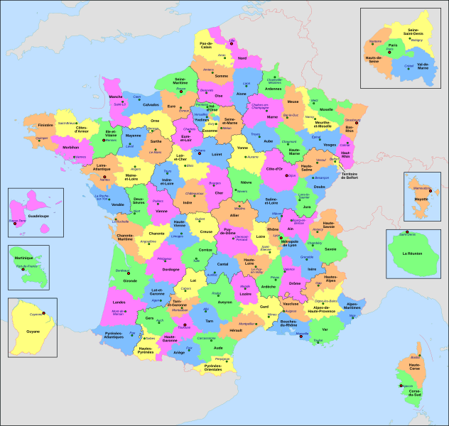
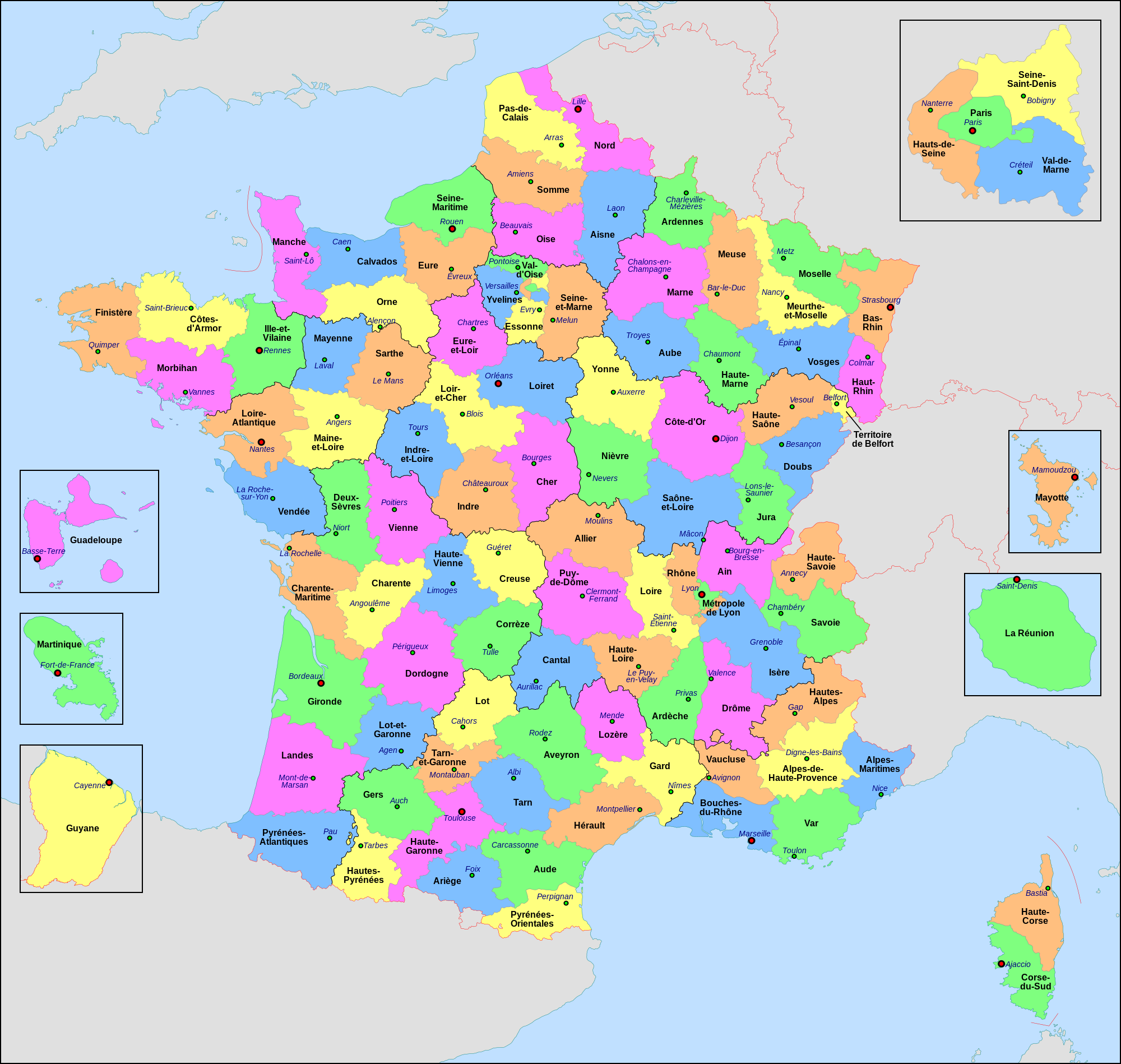
Français : Carte administrative de la France, créée sous Inkscape 0.47 à partir de plusieurs cartes (notamment celle-ci) créées par Sting.
Le fichier comporte vingt-quatre calques : Cadre, Chef-lieux de région, Villes, Chef-lieux de département, Numéros de département, Noms des régions, Nom des départements, **Encarts Départements d'Outre-Mer, **Encart Paris-Petite-Couronne, Coordonnées, Échelle et Mini-carte, Frontières internationales, Côtes, Limites régionales, Limites départementales, Lacs, Fleuves, *Régions métropolitaines, *Départements métropolitains, Terres françaises, Terres étrangères, Mers et océans, Échelle altimétrique, Topographie.
English: Administrative map of France, created under Inkscape 0.47 from several of the maps (especially this one) created by Sting.
The file consists of twenty-four layers: Frame, Administrative Centres of Regions, Towns, Administrative Centres of Departments, Numbers of Departments, Names of Regions, Names of Departments, **Overseas Departements Insets, **Paris Conurbation Inset, Coordinates, Scale and Mini-map, International boundaries, Coasts, Regional boundaries, Departmental boundaries, Lakes, Rivers, *Metropolitan Regions, *Metropolitan Departments, French lands, Foreign lands, Seas and Oceans, Altimetric Scale, Topography.
|
| Ngày | |
| Nguồn gốc | Tác phẩm được tạo bởi người tải lên |
| Tác giả | Nilstilar |
| Phiên bản khác |
|
| SVG genesis |


Giấy phép[sửa]
- Bạn được phép:
- chia sẻ – sao chép, phân phối và chuyển giao tác phẩm
- pha trộn – để chuyển thể tác phẩm
- Theo các điều kiện sau:
- ghi công – Bạn phải ghi lại tác giả và nguồn, liên kết đến giấy phép, và các thay đổi đã được thực hiện, nếu có. Bạn có thể làm các điều trên bằng bất kỳ cách hợp lý nào, miễn sao không ám chỉ rằng người cho giấy phép ủng hộ bạn hay việc sử dụng của bạn.
- chia sẻ tương tự – Nếu bạn biến tấu, biến đổi, hoặc làm tác phẩm khác dựa trên tác phẩm này, bạn chỉ được phép phân phối tác phẩm mới theo giấy phép y hệt hoặc tương thích với tác phẩm gốc.
This image is used on a user page of a Wikimedia user and is stored on Commons according to the rules set out in Commons:Project scope#File in use on Commons only: the uploading of small numbers of images (e.g. of yourself) for use on a personal Commons user page is allowed or Commons:Project scope#File in use in another Wikimedia project: the uploading of small numbers of images (e.g. of yourself) for use on a personal user page of another project is allowed as long as that user is or was an active participant on that project.
If the image ceases to be used it may be eligible for deletion as it may have no educational purpose.
Lịch sử tập tin
Nhấn vào ngày/giờ để xem nội dung tập tin tại thời điểm đó.
| Ngày/Giờ | Hình xem trước | Kích cỡ | Thành viên | Miêu tả | |
|---|---|---|---|---|---|
| hiện tại | 20:29, ngày 22 tháng 6 năm 2022 | | 2.000×1.898 (1,87 MB) | OpesMentis (thảo luận | đóng góp) | Added hyphens on departments' names and towns' names and fixed "Réunion" to "La Réunion" |
| 18:10, ngày 9 tháng 11 năm 2021 |  | 2.000×1.898 (1,87 MB) | Puck04 (thảo luận | đóng góp) | fixed SVG code (was "W3C-invalid") + cleanup using text editor; contains some invisible pathes | |
| 00:40, ngày 1 tháng 5 năm 2020 |  | 2.000×1.898 (4,7 MB) | ChrisPtDe (thảo luận | đóng góp) | File uploaded using svgtranslate tool (https://tools.wmflabs.org/svgtranslate/). Added translation for frp. | |
| 22:17, ngày 28 tháng 4 năm 2020 |  | 2.000×1.898 (4,7 MB) | ChrisPtDe (thảo luận | đóng góp) | File uploaded using svgtranslate tool (https://tools.wmflabs.org/svgtranslate/). Added translation for frp. | |
| 22:56, ngày 25 tháng 4 năm 2020 |  | 2.000×1.898 (4,68 MB) | ChrisPtDe (thảo luận | đóng góp) | File uploaded using svgtranslate tool (https://tools.wmflabs.org/svgtranslate/). Added translation for frp. | |
| 14:13, ngày 4 tháng 11 năm 2018 |  | 2.000×1.898 (4,55 MB) | Nilstilar (thảo luận | đóng góp) | Corse "réunifiée" pose problème | |
| 12:05, ngày 4 tháng 11 năm 2018 |  | 2.000×1.898 (4,54 MB) | Nilstilar (thảo luận | đóng góp) | Corse "réunifiée" (collectivité territoriale unique — département & région — au 1/1/2018) | |
| 13:01, ngày 15 tháng 10 năm 2018 |  | 2.000×1.898 (4,55 MB) | Nilstilar (thảo luận | đóng góp) | Reverted to version as of 18:52, 10 May 2017 (UTC) | |
| 22:30, ngày 28 tháng 12 năm 2017 |  | 2.000×1.898 (2,24 MB) | Ras67 (thảo luận | đóng góp) | frame removed, all invisible data stripped | |
| 18:52, ngày 10 tháng 5 năm 2017 |  | 2.000×1.898 (4,55 MB) | Nilstilar (thảo luận | đóng góp) | Rétablissement des limites régionales (au 01/10/2016) |
Bạn không được phép ghi đè tập tin này.
Trang sử dụng tập tin
7 trang sau sử dụng tập tin này:
Sử dụng tập tin toàn cục
Những wiki sau đang sử dụng tập tin này:
- Trang sử dụng tại ar.wikipedia.org
- Trang sử dụng tại arz.wikipedia.org
- Trang sử dụng tại ast.wikipedia.org
- Trang sử dụng tại ast.wiktionary.org
- Trang sử dụng tại az.wikipedia.org
- Trang sử dụng tại bg.wikipedia.org
- Trang sử dụng tại br.wikipedia.org
- Trang sử dụng tại ca.wikipedia.org
- Trang sử dụng tại cy.wikipedia.org
- Trang sử dụng tại el.wikipedia.org
- Trang sử dụng tại en.wikipedia.org
- Trang sử dụng tại es.wikipedia.org
- Trang sử dụng tại eu.wikipedia.org
- Trang sử dụng tại fr.wikipedia.org
- Département français
- Monument historique (France)
- Géographie de la Guadeloupe
- Économie de la Guadeloupe
- Transports en France
- Liste des ponts de Paris
- Géographie de la Drôme
- Liste des anciennes communes du Loiret
- Économie de La Réunion
- Politique dans la Haute-Vienne
- Politique dans la Creuse
- Climat des Yvelines
- Géographie du Territoire de Belfort
- Culture en Guyane
- Économie du Puy-de-Dôme
- Géographie de la Charente-Maritime
- Économie de l'Oise
- Économie de la Haute-Savoie
- Climat de l'Aveyron
- Climat du Bas-Rhin
- Climat du Haut-Rhin
- Géographie du Loiret
- Arboretum de Balaine
- Transports dans la métropole de Lyon
- Économie de la Haute-Saône
- Climat du Finistère
- Politique à La Réunion
- Géographie d'Eure-et-Loir
- Transport en Corse
- Liste des musées de Paris
Xem thêm các trang toàn cục sử dụng tập tin này.