File:Italy and Illyria 1084 AD.svg
Bước tới điều hướng
Bước tới tìm kiếm

Kích thước bản xem trước PNG này của tập tin SVG: 478×600 điểm ảnh. Độ phân giải khác: 191×240 điểm ảnh | 383×480 điểm ảnh | 612×768 điểm ảnh | 816×1.024 điểm ảnh | 1.633×2.048 điểm ảnh | 586×735 điểm ảnh.
Tập tin gốc (tập tin SVG, 586×735 điểm ảnh trên danh nghĩa, kích thước: 522 kB)
Chú thích
Chú thích
Ghi một dòng giải thích những gì có trong tập tin này

Miêu tả
[sửa]| Miêu tả |
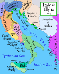
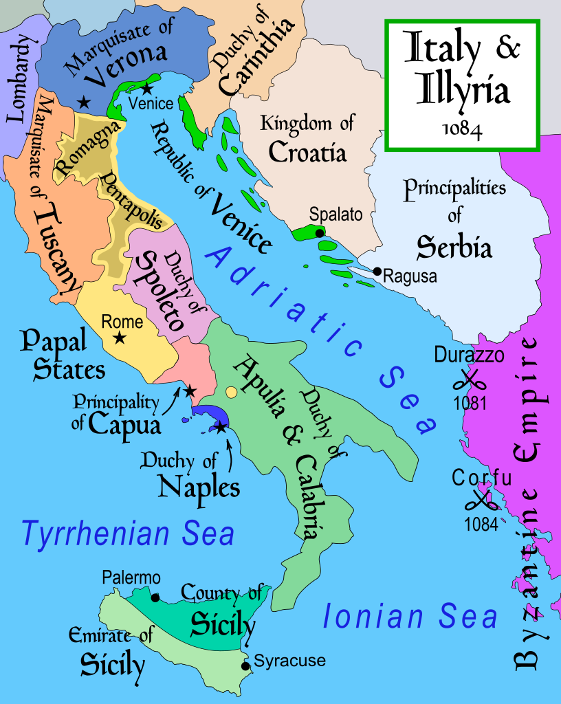
English: Map of Italy and the Illyrian coast in the year 1084.
Part of a series of maps on the history of Italy:
|
| Ngày | |
| Nguồn gốc | Tác phẩm được tạo bởi người tải lên |
| Tác giả | MapMaster |
| Phiên bản khác |
[]
|
| SVG genesis |


References
[sửa]
- This map from Allyn & Bacon, Longman, textbook publishers.
- Bjorklund, Oddvar; Holmboe, Haakon; Rohr, Anders (1970) Historical Atlas of the World, Barnes & Noble, NY, SBN: 389-00253-4.
- Hammond Atlas Corporation (2007) Hammond Historical World Atlas.
- Matthew, Donald (1989) Atlas of Medieval Europe, Time-Life Books.
- This map of 1000 AD Italy from Fordham University, adapted from Muir's Historical Atlas, (1911).
- This map of 1050 AD Italy, from the 1923 The Historical Atlas by William R. Shepherd
- This Wikipedia map of the w:en:Holy Roman Empire
- Šišić, Ferdo (1990) Povijest Hrvata u vrijeme narodnih vladara & the Baška tablet (to denote the territorial integrity of Croatia; islands, coastal borders etc.)
Giấy phép
[sửa]
Tôi, người giữ bản quyền tác phẩm này, từ đây phát hành nó theo giấy phép sau:
Tập tin này được phát hành theo Giấy phép Creative Commons Ghi công–Chia sẻ tương tự 2.5 Chung
- Bạn được phép:
- chia sẻ – sao chép, phân phối và chuyển giao tác phẩm
- pha trộn – để chuyển thể tác phẩm
- Theo các điều kiện sau:
- ghi công – Bạn phải ghi lại tác giả và nguồn, liên kết đến giấy phép, và các thay đổi đã được thực hiện, nếu có. Bạn có thể làm các điều trên bằng bất kỳ cách hợp lý nào, miễn sao không ám chỉ rằng người cho giấy phép ủng hộ bạn hay việc sử dụng của bạn.
- chia sẻ tương tự – Nếu bạn biến tấu, biến đổi, hoặc làm tác phẩm khác dựa trên tác phẩm này, bạn chỉ được phép phân phối tác phẩm mới theo giấy phép y hệt hoặc tương thích với tác phẩm gốc.
derivative works
[sửa]
Derivative works of this file: Italy and Illyria 1084 v2-ar.svg
Lịch sử tập tin
Nhấn vào ngày/giờ để xem nội dung tập tin tại thời điểm đó.
| Ngày/Giờ | Hình xem trước | Kích cỡ | Thành viên | Miêu tả | |
|---|---|---|---|---|---|
| hiện tại | 19:19, ngày 22 tháng 10 năm 2017 | | 586×735 (522 kB) | Ras67 (thảo luận | đóng góp) | frame removed |
| 12:16, ngày 23 tháng 11 năm 2011 |  | 588×735 (644 kB) | Kathovo (thảo luận | đóng góp) | Reverted to version as of 12:20, 29 July 2007 not an svg | |
| 18:06, ngày 23 tháng 1 năm 2011 |  | 480×600 (224 kB) | Er-vet-en (thảo luận | đóng góp) | whoops, sorry for this | |
| 18:04, ngày 23 tháng 1 năm 2011 |  | 480×600 (224 kB) | Er-vet-en (thảo luận | đóng góp) | resize | |
| 17:50, ngày 23 tháng 1 năm 2011 |  | 744×1.052 (224 kB) | Er-vet-en (thảo luận | đóng góp) | plit and some islands are are actually in Croatia's dominion from about 1076 (since the previous map relied on maps from earlier) This is proven by the acclaimed historian Ferdo Šišić, and the culturally significant Bashka tablet (which proved that ki | |
| 12:20, ngày 29 tháng 7 năm 2007 |  | 588×735 (644 kB) | Lokal Profil (thảo luận | đóng góp) | Cleaned up code (specifically loads of empty groups) | |
| 05:43, ngày 15 tháng 4 năm 2007 |  | 588×735 (695 kB) | MapMaster (thảo luận | đóng góp) | Minor changes | |
| 03:56, ngày 13 tháng 2 năm 2007 |  | 588×735 (694 kB) | MapMaster (thảo luận | đóng góp) | Map of Italy and the Illyrian coast in the year 1084 |
Bạn không được phép ghi đè tập tin này.
Trang sử dụng tập tin
73 trang sau sử dụng tập tin này:
- Atlas of Croatia
- Atlas of Slovenia
- User:J budissin/Uploads/BiH/2017 October 21-31
- User:MapMaster
- File:Duchy of Carinthia-1000 AD.svg
- File:Italia 1000 AD-Ido.svg
- File:Italia 1796-ca.svg
- File:Italia 1796-es.svg
- File:Italia 1796-fr.svg
- File:Italy 1000 AD-de.svg
- File:Italy 1000 AD-el.png
- File:Italy 1000 AD-es.svg
- File:Italy 1000 AD-he.svg
- File:Italy 1000 AD-ru.svg
- File:Italy 1000 AD.svg
- File:Italy 1494 AD-ar.png
- File:Italy 1494 AD.png
- File:Italy 1494 el.png
- File:Italy 1796-hu.svg
- File:Italy 1796.svg
- File:Italy 1796 AD-ca.svg
- File:Italy 1796 AD-el.png
- File:Italy 1796 de.svg
- File:Italy 1796 heb.jpg
- File:Italy 1796 it.svg
- File:Italy and Illyria 1084 AD-ca.svg
- File:Italy and Illyria 1084 AD-cs.svg
- File:Italy and Illyria 1084 AD-es.svg
- File:Italy and Illyria 1084 AD-fr.svg
- File:Italy and Illyria 1084 AD-hu.svg
- File:Italy and Illyria 1084 AD-it.svg
- File:Italy and Illyria 1084 AD-ru.svg
- File:Italy and Illyria 1084 AD-sv.png
- File:Italy and Illyria 1084 AD-vi.svg
- File:Italy and Illyria 1084 AD-zh.png
- File:Italy and Illyria 1084 AD-zh.svg
- File:Italy and Illyria 1084 AD.svg
- File:Italy and Illyria 1084 v2-ar.svg
- File:Italy and Illyria 1084 v2-es.svg
- File:Italy and Illyria 1084 v2.svg (tập tin đổi hướng)
- User:MapMaster
- File:Italy 1000 AD.svg
- Atlas of Croatia
- Atlas of Slovenia
- File:Italy 1000 AD-de.svg
- File:Italy 1000 AD-es.svg
- File:Italy and Illyria 1084 AD-cs.svg
- File:Italy 1000 AD-he.svg
- File:Italy and Illyria 1084 AD-it.svg
- File:Italy 1000 AD-ru.svg
- File:Italy and Illyria 1084 AD-ru.svg
- File:Italy 1796 heb.jpg
- File:Italy 1494 AD-ar.png
- File:Duchy of Carinthia-1000 AD.svg
- File:Italy and Illyria 1084 v2-ar.svg
- File:Italia 1796-es.svg
- File:Italy 1796.svg
- File:Italia 1796-fr.svg
- File:Italy and Illyria 1084 v2 pt.svg
- File:Italy 1796 de.svg
- File:Italy 1796 it.svg
- File:Italy and Illyria 1084 v2-es.svg
- File:Italy 1796 AD-el.png
- File:Italy 1494 el.png
- File:Italy 1000 AD-el.png
- Template:Other versions/Italy 1796 AD
- File:Italy 1796-hu.svg
- File:Italia 1000 AD-Ido.svg
- File:Italia 1796-ca.svg
- File:Italy 1796 AD-ca.svg
- File:Italy and Illyria 1084 v2 pt.svg
- Template:Other versions/Italy 1796 AD
- Template:Other versions/Italy and Illyria 1084 AD
Sử dụng tập tin toàn cục
Những wiki sau đang sử dụng tập tin này:
- Trang sử dụng tại ar.wikipedia.org
- Trang sử dụng tại azb.wikipedia.org
- Trang sử dụng tại bg.wikipedia.org
- Trang sử dụng tại bn.wikipedia.org
- Trang sử dụng tại bs.wikipedia.org
- Trang sử dụng tại ca.wikipedia.org
- Trang sử dụng tại cs.wikipedia.org
- Trang sử dụng tại da.wikipedia.org
- Trang sử dụng tại de.wikipedia.org
- Trang sử dụng tại el.wikipedia.org
- Trang sử dụng tại en.wikipedia.org
- 1084
- Robert Guiscard
- Republic of Florence
- Battle of Dyrrhachium (1081)
- Sikelgaita
- User:MapMaster
- Domenico Selvo
- Vitale Faliero
- History of Islam in southern Italy
- Norman conquest of southern Italy
- Byzantine–Norman wars
- County of Apulia and Calabria
- Terre Matildiche
- Amicus of Giovinazzo
- User:Falcaorib/Italy
- Trang sử dụng tại et.wikipedia.org
Xem thêm các trang toàn cục sử dụng tập tin này.
Đặc tính hình
Thể loại:
- Battle of Dyrrhachium (1081)
- Maps of 11th-century Italy
- Maps of the Republic of Venice
- Maps of the Duchy of Spoleto
- Principality of Capua
- Maps of the Kingdom of Sicily
- Emirate of Sicily
- County of Sicily
- SVG maps of the history of Italy
- Marquisate of Tuscany
- Maps of the Papal States
- Papal States in the 1080s
- Maps of the history of Croatia in the Middle Ages
- Maps of 11th-century Serbia
- Maps of medieval Bosnian and neighboring states
- Maps of the history of the medieval Balkans
- Constantine Bodin
- English-language SVG maps showing history
- Maps of the history of Bosnia and Herzegovina in the Early Middle Ages