File:Japanese Empire2.png
Bước tới điều hướng
Bước tới tìm kiếm
Kích thước hình xem trước: 515×599 điểm ảnh. Độ phân giải khác: 206×240 điểm ảnh | 412×480 điểm ảnh | 660×768 điểm ảnh | 1.032×1.201 điểm ảnh.
Tập tin gốc (1.032×1.201 điểm ảnh, kích thước tập tin: 927 kB, kiểu MIME: image/png)
Chú thích
Chú thích
Ghi một dòng giải thích những gì có trong tập tin này

|
Hình ảnh thuộc thể loại "military map" cần được vẽ lại bằng đồ họa vector theo định dạng tập tin SVG. Để biết ưu điểm của định dạng này, hãy đọc Commons:Media for cleanup. Nếu tập tin này đã có SVG, xin hãy tải lên đây rồi thay bản mẫu này bằng {{vector version available|tên hình mới.svg}}.
|
Miêu tả[sửa]
| Miêu tả |
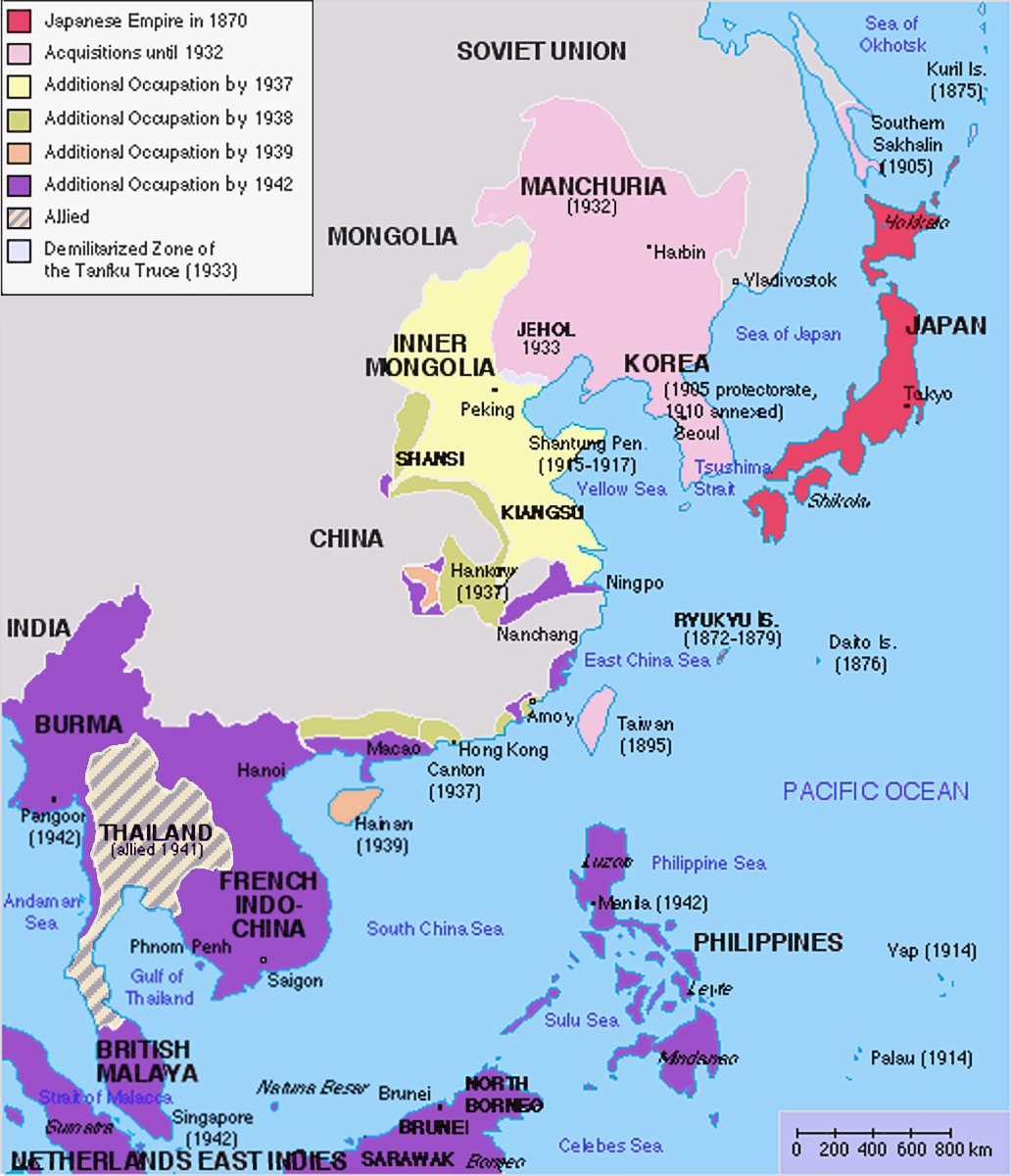
English: Original map was created by Kokiri, based in part on File:BlankMap-World.png. Subsequent modifications to colors performed by Huhsunqu. Additional corrections (fixed Ryukyu Islands, Sichuan, grammar in table) by Markalexander100. |
||||||||
| Ngày | (original upload date at English Wikipedia) | ||||||||
| Nguồn gốc |
Là ảnh phái sinh từ: Japanese Empire.png |
||||||||
| Tác giả | Kokiri tại Wikipedia Tiếng Anh, modifications by Huhsunqu and Markalexander100. | ||||||||
| Giấy phép (Dùng lại tập tin) |
|
||||||||
| Phiên bản khác |
Derivative works of this file: |

.png)
Nhật trình tải lên đầu tiên[sửa]
The original upload log was here. The usernames refer to the English Wikipedia. Not to be confused with File:Japanese empire.png.
04:00, 6 October 2005 . . Huhsunqu (talk | contribs | block) 508 × 591 (44,305 bytes)02:42, 21 August 2004 . . Nanshu (talk | contribs | block) 508 × 591 (45,178 bytes)09:38, 18 August 2004 . . Kokiri (talk | contribs | block) 508 × 591 (46,867 bytes) (map of the Japanese Empire, drawn myself)
Lịch sử tập tin
Nhấn vào ngày/giờ để xem nội dung tập tin tại thời điểm đó.
| Ngày/Giờ | Hình xem trước | Kích cỡ | Thành viên | Miêu tả | |
|---|---|---|---|---|---|
| hiện tại | 12:26, ngày 3 tháng 3 năm 2023 | | 1.032×1.201 (927 kB) | Hohum (thảo luận | đóng góp) | Brighten |
| 12:24, ngày 3 tháng 3 năm 2023 |  | 1.032×1.201 (944 kB) | Hohum (thảo luận | đóng góp) | less garish colours | |
| 03:53, ngày 10 tháng 1 năm 2023 |  | 1.032×1.201 (1.020 kB) | Artanisen (thảo luận | đóng góp) | Added allied color. Thailand was in a coerced alliance (1941) thus part of the empire | |
| 06:20, ngày 22 tháng 6 năm 2022 |  | 1.032×1.201 (683 kB) | Crab2814 (thảo luận | đóng góp) | Removed Tongking- France gave Japan military access to that region in 1940, not an occupational right. Fixed Sakhalin and Hainan. Removed Thailand, which was allied not occupied by Japan. | |
| 11:58, ngày 3 tháng 8 năm 2020 |  | 1.437×1.201 (1,8 MB) | Artanisen (thảo luận | đóng góp) | Bigger size and sharper version of the same map. The rest is the same. | |
| 11:47, ngày 5 tháng 7 năm 2007 |  | 707×591 (32 kB) | Mahahahaneapneap (thảo luận | đóng góp) | pngcrushed | |
| 01:31, ngày 27 tháng 5 năm 2007 |  | 707×591 (48 kB) | Gryffindor (thảo luận | đóng góp) | {{svg}} {{GFDL}} Modified version of Image:Japanese_Empire.png. Fixed Ryukyu Islands, Sichuan, grammar in table. Category:Maps of the history of Japan Category:Maps of the history of Korea Category:Maps of the history of Vietnam [[Categ | |
| 15:13, ngày 27 tháng 2 năm 2007 |  | 508×591 (36 kB) | Cristan (thảo luận | đóng góp) | Optimized using PNGOUT | |
| 11:24, ngày 22 tháng 12 năm 2005 |  | 508×591 (47 kB) | Markalexander100 (thảo luận | đóng góp) | {{GFDL}} Modified version of Image:Japanese_Empire.png. Fixed Ryukyu Islands, Sichuan, grammar in table. |
Bạn không được phép ghi đè tập tin này.
Trang sử dụng tập tin
23 trang sau sử dụng tập tin này:
- Atlas of Brunei
- Atlas of Cambodia
- Atlas of Indonesia
- Atlas of Japan
- Atlas of Laos
- Atlas of Malaysia
- Atlas of Myanmar
- Atlas of Singapore
- Atlas of Taiwan
- Atlas of Thailand
- Atlas of Vietnam
- Atlas of World War II
- Atlas of colonialism
- Atlas of the People's Republic of China
- User:Chumwa/OgreBot/Transport Maps/2020 August 1-10
- User:Chumwa/OgreBot/Transport Maps/2022 June 21-30
- User:Chumwa/OgreBot/Travel and communication maps/2020 August 1-10
- User:Chumwa/OgreBot/Travel and communication maps/2022 June 21-30
- User:Magog the Ogre/Maps of conflicts/2020 August
- User:Magog the Ogre/Maps of conflicts/2022 June
- User:Magog the Ogre/Maps of conflicts/2023 January
- User:Magog the Ogre/Maps of conflicts/2023 March
- File:Império Japonês (1870-1942).png
Sử dụng tập tin toàn cục
Những wiki sau đang sử dụng tập tin này:
- Trang sử dụng tại af.wikipedia.org
- Trang sử dụng tại ar.wikipedia.org
- Trang sử dụng tại bn.wikipedia.org
- Trang sử dụng tại ca.wikipedia.org
- Trang sử dụng tại cs.wikipedia.org
- Trang sử dụng tại de.wikipedia.org
- Trang sử dụng tại en.wikipedia.org
- Trang sử dụng tại eu.wikipedia.org
- Trang sử dụng tại fa.wikipedia.org
- Trang sử dụng tại fi.wikipedia.org
- Trang sử dụng tại fr.wikipedia.org
- Trang sử dụng tại gl.wikipedia.org
- Trang sử dụng tại hak.wikipedia.org
- Trang sử dụng tại he.wikipedia.org
- Trang sử dụng tại hy.wikipedia.org
- Trang sử dụng tại it.wikipedia.org
- Trang sử dụng tại ja.wikipedia.org
- Trang sử dụng tại min.wikipedia.org
- Trang sử dụng tại mk.wikipedia.org
- Trang sử dụng tại ms.wikipedia.org
- Trang sử dụng tại nl.wikipedia.org
- Trang sử dụng tại oc.wikipedia.org
- Trang sử dụng tại pam.wikipedia.org
- Trang sử dụng tại pt.wikipedia.org
- Trang sử dụng tại ro.wikipedia.org
Xem thêm các trang toàn cục sử dụng tập tin này.
Đặc tính hình
Thể loại:
- Empire of Vietnam in 1945
- Maps of the Empire of Japan
- Maps of the history of Korea
- Maps of the history of Vietnam
- Maps of the history of Laos
- Maps of the history of Cambodia
- Maps of the history of the Philippines
- Maps of the Republic of China (1912–1949)
- Maps of the history of Indonesia
- Maps of British Malaya
- Maps of Burma during World War II
- Maps of the history of Taiwan
- Maps of the history of Thailand