File:Jorge Aguiar 1492 MR.jpg
Bước tới điều hướng
Bước tới tìm kiếm

Kích thước hình xem trước: 776×600 điểm ảnh. Độ phân giải khác: 311×240 điểm ảnh | 621×480 điểm ảnh | 994×768 điểm ảnh | 1.280×990 điểm ảnh | 2.560×1.979 điểm ảnh | 5.016×3.878 điểm ảnh.
Tập tin gốc (5.016×3.878 điểm ảnh, kích thước tập tin: 13,06 MB, kiểu MIME: image/jpeg)
Chú thích
Chú thích
Ghi một dòng giải thích những gì có trong tập tin này
Miêu tả[sửa]
_en.png)
.png)
.jpg)
Giấy phép[sửa]
|
Tác phẩm này thuộc về phạm vi công cộng tại quốc gia gốc và các quốc gia và vùng lãnh thổ có thời hạn bản quyền là cuộc đời tác giả cộng thêm 100 trở xuống. | |
| Tập tin này đã được đánh dấu là không bị hạn chế dưới luật bản quyền, kể cả tất cả những quyền liên quan và lần cận. | |
Đánh giá[sửa]
|
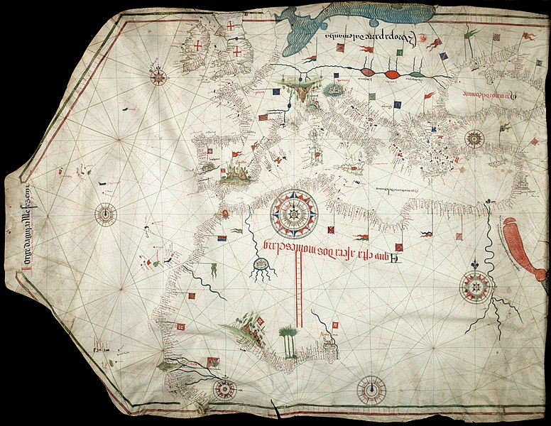
Bức hình này đã được chọn làm hình ảnh của ngày trên Wikimedia Commons vào ngày 10 tháng 6 năm 2011. Dưới đây là lời mô tả: English: Reproduction of Jorge de Aguiar's chart of the Mediterranean, Western Europe and African Coast (1492). Size of the original: 1030×770 mm Các ngôn ngữ khác:
Deutsch: Reproduktion von Jorge de Aguiars Karte des Mittelmeerraumes, der westeuropäischen und afrikanischen Küste aus dem Jahr 1492 – Größe des Originales: 1.030 mm × 770 mm English: Reproduction of Jorge de Aguiar's chart of the Mediterranean, Western Europe and African Coast (1492). Size of the original: 1030×770 mm Español: Reproducción del mapa de Jorge de Aguiar de la cuenca mediterránea, Europa Occidental y la costa africana (1492). Tamaño del original: 1030×770 mm. Esperanto: Reproduktaĵo de mapo pri la mediteraneaj, okcidenteŭropaj kaj afrikaj marbordoj, farita de la kartografo Jorge de Aguiar en 1492. Mezuroj de la originalo: 1030×770 mm. Français : Reproduction de la carte des côtes méditerranéenne, d'Europe et d'Afrique de l'Ouest par Jorge de Aguiar (1492). Italiano: Riproduzione della carta di Jorge de Aguiar delle coste del Mediterraneo, dell'Europa occidentale e dell'Africa settenrionale (1492). Dimensioni dell'originale: 1030×770 mm Magyar: Jorge de Aguiar térképének másolata: a Mediterrán térség, Nyugat-Európa, és az Afrikai part (1492). Méret: 1030×770 mm Nederlands: Een reproductie van de kaart van de hand van Jorge de Aguiar van de Middellandse Zee, West-Europa en de Afrikaanse kust (1492). Het origineel is 1030×770 mm. Русский: Репродукция карты Средиземного Моря, Европы и африканского побережья, составленной Хорхе де Агияром (1492). Українська: Відтворення карти Середземномор'я, Західної Європи і африканського узбережжя португальського картографа Хорхе де Агілара (Jorge de Aguiar) (1492). Розмір оригіналу: 1030×770 мм. Із зібрань Бібліотеки Бейнеке рідких книг і рукописів (Beinecke Rare Book & Manuscript Library) Єльського університету 日本語: ジョルジュ・デ・アギアルによる地中海、西ヨーロッパ及びアフリカ沿岸の海図(1492年)の複製。原画の寸法1030ミリメートル×770ミリメートル。 中文: 乔治·德阿吉亚尔绘制的地中海、西欧和非洲海岸图(1492年)复制品。原始尺寸:1030×770mm。 |
Lịch sử tập tin
Nhấn vào ngày/giờ để xem nội dung tập tin tại thời điểm đó.
| Ngày/Giờ | Hình xem trước | Kích cỡ | Thành viên | Miêu tả | |
|---|---|---|---|---|---|
| hiện tại | 12:32, ngày 24 tháng 11 năm 2010 | | 5.016×3.878 (13,06 MB) | Alvesgaspar (thảo luận | đóng góp) | {{Information |Description={{en|1=Reproduction of Jorge de Aguiar's chart of the Mediterranean, Western Europe and African Coast (1492). Size of the origial: 1030 x 770 mm}} |Source=Beinecke Rare Book and Manuscript Library, University of Yale, New Have, |
Bạn không được phép ghi đè tập tin này.
Trang sử dụng tập tin
37 trang sau sử dụng tập tin này:
- User:Alvesgaspar/Maps & charts
- User talk:Alvesgaspar/archive17
- Commons:Featured picture candidates/File:Jorge Aguiar 1492 MR.jpg
- Commons:Featured picture candidates/Log/December 2010
- Commons:Featured pictures/Non-photographic media/Maps
- Commons:Featured pictures/chronological/2010-B
- Commons:Picture of the Year/2010/Galleries/Artworks
- Commons:Picture of the Year/2010/Galleries/Artworks/Large
- Commons:Picture of the Year/2010/Galleries/Artworks/Small
- Commons:Picture of the Year/2010/Galleries/Index/15
- Commons:Picture of the Year/2010/Galleries/Index/Artworks
- Commons:Picture of the Year/2010/Galleries/Table
- Commons:Picture of the Year/2010/Galleries/Table/12
- Commons:Picture of the Year/2010/R1/File:Jorge Aguiar 1492 MR.jpg
- Commons:Picture of the Year/2010/Results/R1/ALL/Table
- Commons:Picture of the Year/2010/Results/R1/Artworks
- Commons:Picture of the Year/2010/Results/R1/Artworks/Table
- Commons:Potd/2011-06 (de)
- Commons:Potd/2011-06 (nl)
- Commons:Potd/2011-06 (pt)
- Commons talk:Picture of the Year/2010/Galleries/Table
- Commons talk:Picture of the Year/2010/Results/R1/ALL/Table
- Template:Potd/2011-06
- Template:Potd/2011-06-10
- Template:Potd/2011-06-10 (de)
- Template:Potd/2011-06-10 (en)
- Template:Potd/2011-06-10 (eo)
- Template:Potd/2011-06-10 (es)
- Template:Potd/2011-06-10 (fr)
- Template:Potd/2011-06-10 (hu)
- Template:Potd/2011-06-10 (it)
- Template:Potd/2011-06-10 (ja)
- Template:Potd/2011-06-10 (nl)
- Template:Potd/2011-06-10 (ru)
- Template:Potd/2011-06-10 (uk)
- Template:Potd/2011-06-10 (zh-hans)
- Template:Potd/2011-06 (zh-hans)
Sử dụng tập tin toàn cục
Những wiki sau đang sử dụng tập tin này:
- Trang sử dụng tại ar.wikipedia.org
- Trang sử dụng tại ba.wikipedia.org
- Trang sử dụng tại be-tarask.wikipedia.org
- Trang sử dụng tại bn.wikipedia.org
- Trang sử dụng tại ca.wikipedia.org
- Trang sử dụng tại crh.wikipedia.org
- Trang sử dụng tại cv.wikipedia.org
- Trang sử dụng tại en.wikipedia.org
- User:Alvesgaspar
- Portolan chart
- Wikipedia:Featured pictures/Diagrams, drawings, and maps/Maps
- Wikipedia:Featured pictures thumbs/26
- Wikipedia:Featured picture candidates/December-2010
- Wikipedia:Featured picture candidates/File:Jorge Aguiar 1492 MR.jpg
- Wikipedia:Wikipedia Signpost/2010-12-27/Features and admins
- Iberian cartography, 1400–1600
- Talk:Iberian cartography, 1400–1600
- Template:POTD/2011-06-10
- Wikipedia:Picture of the day/June 2011
- Wikipedia:Main Page history/2011 June 10
- User:Walrasiad/Maps
- User talk:Alvesgaspar/archive2
- Wikipedia:Wikipedia Signpost/Single/2010-12-27
- Portal:Geography/Selected picture
- Trang sử dụng tại es.wikipedia.org
- Trang sử dụng tại fa.wikipedia.org
- Trang sử dụng tại fr.wikipedia.org
- Trang sử dụng tại hu.wikipedia.org
- Trang sử dụng tại it.wikipedia.org
- Trang sử dụng tại kk.wikipedia.org
- Trang sử dụng tại ko.wikipedia.org
- Trang sử dụng tại lbe.wikipedia.org
- Trang sử dụng tại oc.wikipedia.org
- Trang sử dụng tại os.wikipedia.org
- Trang sử dụng tại pl.wikipedia.org
- Trang sử dụng tại pt.wikipedia.org
- Trang sử dụng tại ro.wikipedia.org
- Trang sử dụng tại ru.wikipedia.org
- Trang sử dụng tại ru.wikinews.org
- Trang sử dụng tại sah.wikipedia.org
Xem thêm các trang toàn cục sử dụng tập tin này.