File:Map of Oregon NA.png
Bước tới điều hướng
Bước tới tìm kiếm

Kích thước hình xem trước: 800×541 điểm ảnh. Độ phân giải khác: 320×217 điểm ảnh | 640×433 điểm ảnh | 1.024×693 điểm ảnh | 1.280×866 điểm ảnh | 1.967×1.331 điểm ảnh.
Tập tin gốc (1.967×1.331 điểm ảnh, kích thước tập tin: 2,15 MB, kiểu MIME: image/png)
Chú thích
Chú thích
Ghi một dòng giải thích những gì có trong tập tin này
Miêu tả[sửa]
| Miêu tả |
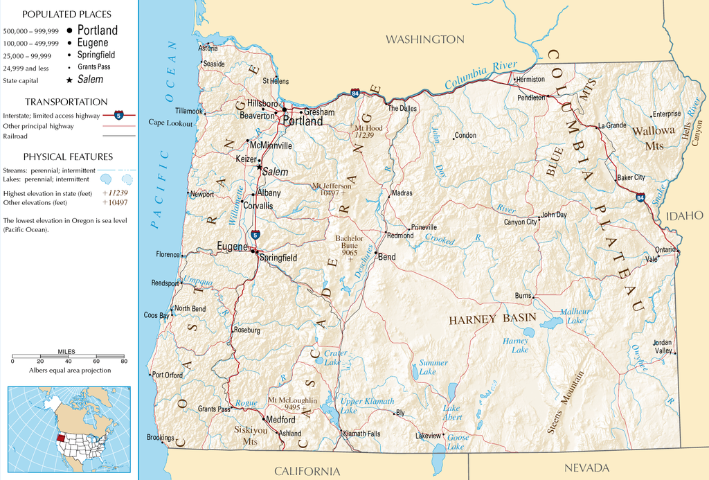
English: Topographic map of the geography of Oregon — with major rivers shown.
|
| Nguồn gốc | National Atlas |
| Tác giả | Không rõ |
Giấy phép[sửa]
This map was obtained from an edition of the National Atlas of the United States. Like almost all works of the U.S. federal government, works from the National Atlas are in the public domain in the United States.
Online access: NationalAtlas.gov | 1970 print edition: Library of Congress, Perry-Castañeda Library
|
Lịch sử tập tin
Nhấn vào ngày/giờ để xem nội dung tập tin tại thời điểm đó.
| Ngày/Giờ | Hình xem trước | Kích cỡ | Thành viên | Miêu tả | |
|---|---|---|---|---|---|
| hiện tại | 05:46, ngày 16 tháng 10 năm 2007 | | 1.967×1.331 (2,15 MB) | Peteforsyth (thảo luận | đóng góp) | removed extraneous text and logo from public domain image |
| 08:13, ngày 15 tháng 8 năm 2006 |  | 2.122×1.640 (2,75 MB) | Huebi~commonswiki (thảo luận | đóng góp) | {{Information| |Description=Map of Oregon |Source=[http://www.nationalatlas.gov National Atlas] }} Category:Maps of the United States Category:Maps of Oregon {{PD-USGov-Atlas}} |
Bạn không được phép ghi đè tập tin này.
Trang sử dụng tập tin
Không có trang nào sử dụng tập tin này.
Sử dụng tập tin toàn cục
Những wiki sau đang sử dụng tập tin này:
- Trang sử dụng tại als.wikipedia.org
- Trang sử dụng tại ar.wikipedia.org
- Trang sử dụng tại de.wikipedia.org
- Trang sử dụng tại en.wikipedia.org
- Trang sử dụng tại eo.wikipedia.org
- Trang sử dụng tại fi.wikipedia.org
- Trang sử dụng tại fr.wikipedia.org
- Trang sử dụng tại hr.wiktionary.org
- Trang sử dụng tại hsb.wikipedia.org
- Trang sử dụng tại hu.wikipedia.org
- Trang sử dụng tại incubator.wikimedia.org
- Trang sử dụng tại is.wikipedia.org
- Trang sử dụng tại it.wikipedia.org
- Trang sử dụng tại ja.wikipedia.org
- Trang sử dụng tại kk.wikipedia.org
- Trang sử dụng tại lt.wikipedia.org
- Trang sử dụng tại mr.wikipedia.org
- Trang sử dụng tại nds-nl.wikipedia.org
- Trang sử dụng tại pa.wikipedia.org
- Trang sử dụng tại ru.wikipedia.org
- Trang sử dụng tại sw.wikipedia.org
- Trang sử dụng tại vi.wikipedia.org
- Trang sử dụng tại zea.wikipedia.org