File:USA 09855 Grand Canyon Luca Galuzzi 2007.jpg
לקובץ המקורי (2,000 × 1,333 פיקסלים, גודל הקובץ: 2.99 מ"ב, סוג MIME: image/jpeg)
כיתובים
כיתובים
| תיאור |
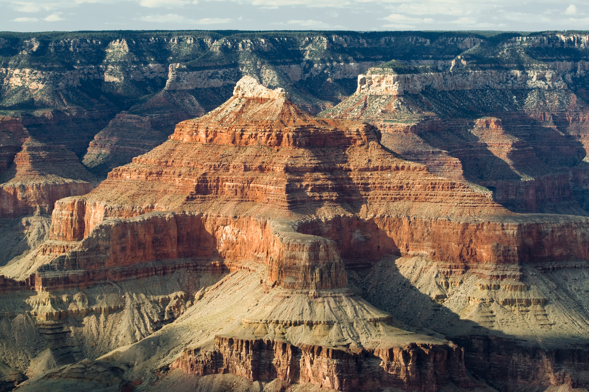
English: (original description)--Grand Canyon, Arizona. Nearly two billion years of the Earth's history have been exposed as the Colorado River and its tributaries cut their channels through layer after layer of rock while the Colorado Plateau was uplifted. Arizona, USA. (view approx. due-north)--From Dana Butte region, on en:Tonto Trail-(on the Tonto Platform), southside of Granite Gorge, Colorado River. The en:Isis Temple prominence, 7,012 feet (2,137 m), is on an uplifted, faulted-block, with Sumner Butte (unseen) to right, and a 3rd "prominence", also part of the block, at the southwest of Bright Angel Canyon-(creek)-(Bright Angel Fault). The northeast flank of the block is down Phantom Creek-(canyon, to Bright Angel Canyon)-(the Grandview Fault). The geology units beyond, are consequently offset, (lower by 200-250? ft). The landmark point, to the right of ISIS peak, is the end of The Colonnade, 7,296 feet (2,224 m), on the next canyon southeast from Tiyo Point, 7,762 feet (2,366 m), of the southwest Kaibab Plateau, (seen in the background); (the viewpoint looks slightly uphill from Dana Point). Tiyo Point is 3-mi from Isis Temple (peak), and The Colonnade, (though appears as a twin peak), is 1.5 mi from Isis. Isis Temple is topped by the lowest (buff-white unit), en:Coconino Sandstone, then a short slope of Hermit Shale, and the Supai Group "redbeds". The cliffs below the 'redbeds' are Redwall Limestone; then upon the slopes of en:Muav Limestone & Bright Angel Shale (No Tapeats Sandstone). Instead the base of Isis Temple sits on a 'mountain island' of Shinumo Quartzite of the en:Ukar Group, part of the Grand Canyon basement rock geology. (Tapeats Sandstone is in all the landforms surrounding the uplifted block.) |
||
| תאריך יצירה | |||
| מקור | Photo taken by (Luca Galuzzi) * http://www.galuzzi.it | ||
| יוצר | Luca Galuzzi (Lucag) | ||
| אישורים והיתרים (שימוש חוזר בקובץ זה) |
I, Luca Galuzzi, בעל זכויות היוצרים על היצירה הזאת, מפרסם אותה בזאת תחת הרישיון הבא: הקובץ הזה מתפרסם לפי תנאי רישיון קריאייטיב קומונז ייחוס-שיתוף זהה 2.5 כללי. ייחוס: I, Luca Galuzzi
|

| Annotations | This image is annotated: View the annotations at Commons |
היסטוריית הקובץ
ניתן ללחוץ על תאריך/שעה כדי לראות את הקובץ כפי שנראה באותו זמן.
| תאריך/שעה | תמונה ממוזערת | ממדים | משתמש | הערה | |
|---|---|---|---|---|---|
| נוכחית | 21:26, 5 בספטמבר 2007 | | 1,333 × 2,000 (2.99 מ"ב) | Lucag (שיחה | תרומות) | {{Information |Description=Grand Canyon, Arizona. Nearly two billion years of the Earth's history have been exposed as the Colorado River and its tributaries cut their channels through layer after layer of rock while the Colorado Plateau was uplifted. Ari |
אין באפשרותך לדרוס את הקובץ הזה.
שימוש בקובץ
הדפים הבאים משתמשים בקובץ הזה:
שימוש גלובלי בקובץ
אתרי הוויקי השונים הבאים משתמשים בקובץ זה:
- שימוש באתר de.wikipedia.org
- שימוש באתר en.wikipedia.org
- שימוש באתר en.wikiversity.org
- שימוש באתר he.wikipedia.org
- שימוש באתר hu.wikipedia.org
- שימוש באתר pl.wikipedia.org
- שימוש באתר pl.wiktionary.org
מטא־נתונים
- July 2007 in Arizona
- Erosion
- Isis Temple, Arizona
- The Colonnade terminus
- Phantom Canyon (upper canyon)
- Phantom Canyon (lower canyon)
- Phantom Canyon
- The Colonnade
- Isis Temple, Arizona closeup
- The Colonnade terminus closeup
- Views from Dana Butte
- Views from Tonto Trail
- Kaibab Limestone in Arizona
- Toroweap Formation
- Coconino Sandstone in Arizona
- Hermit Formation
- Hermit Formation slopes
- Supai Group
- Esplanade Sandstone
- Supai Group - redbeds
- Supai Group - redbeds closeup
- Redwall Limestone
- Redwall Limestone platform
- Redwall Limestone cliffs
- Tonto Group
- Muav Limestone
- Muav Limestone cliffs
- Bright Angel Shale
- Tonto Platform
- Tapeats Sea
- Unkar Group
- Unkar Group (Central Grand Canyon)
- Shinumo Quartzite
- Unkar Group Horst (Bright Angel Creek)
- Grandview Fault - Bright Angel Fault intersection
- Grandview Fault
- Bright Angel Fault
- Faults of the Grand Canyon