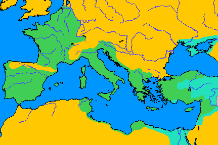
File:Roman Empire in 50 BC.png
- Fichier
- Historique du fichier
- Utilisations locales du fichier
- Utilisations du fichier sur d’autres wikis
Roman_Empire_in_50_BC.png (431 × 287 pixels, taille du fichier : 7 kio, type MIME : image/png)
Légendes
Légendes
Sommaire
Description[modifier]
| DescriptionRoman Empire in 50 BC.png |
anglais References
This map can be adaptedSome of the information on this map can be incorrect and could be corrected. I have changed Cyrenaica for instance. It was Roman since 98 BC, which was not shown on the original map of the Atlas zur Weltgeschichte. Just send a message to me.--Daanschr 10:35, 7 May 2006 (UTC) Do you want to join a Mapproject?This map is part of a mapproject that i started. This mapproject has two goals: creating maps with the ultimate historical accuracy and to improve historical maps. At the moment i am the only participant of this project, allthough i got some help from a few users to get acquainted with computer programs and the abilities of Wikipedia. I hope that other people could join me, so the expansion of historically accurate maps could be quicker. Historical accuracyI want to create maps that link to sources. The main source will be historical atlases in bookform and history books. For research tasks, see talk page. |
||
| Date | |||
| Source |
|
||
| Auteur | Daanschr (d · contributions) |
Conditions d’utilisation[modifier]
| Public domainPublic domainfalsefalse |
| Cette œuvre a été placée dans le domaine public par son auteur, Daanschr. Ceci s’applique dans le monde entier. Dans certains pays, ceci peut ne pas être possible ; dans ce cas : |
Historique du fichier
Cliquer sur une date et heure pour voir le fichier tel qu'il était à ce moment-là.
| Date et heure | Vignette | Dimensions | Utilisateur | Commentaire | |
|---|---|---|---|---|---|
| actuel | 16 juillet 2007 à 10:13 |  | 431 × 287 (7 kio) | Nihad Hamzic (d | contributions) | Reduced image size by half, by losslessly reducing color domain. |
| 17 décembre 2006 à 10:07 |  | 431 × 287 (14 kio) | Electionworld (d | contributions) | {{ew|en|Daanschr}} == Licensing == {{PD-user|Daanschr}} == References == *H. Kinder and W. Hilgemann, ''Sesam. Atlas bij de wereldgeschiedenis'' (Vertaald uit het duits door Jacoba M. Vreugdenhil, Baarn 1965) 90. == This map can be adapted == Some of th |
Vous ne pouvez pas remplacer ce fichier.
Utilisations locales du fichier
Les 29 pages suivantes utilisent ce fichier :
- Atlas of Albania
- Atlas of Austria
- Atlas of Belgium
- Atlas of Bosnia and Herzegovina
- Atlas of Bulgaria
- Atlas of Croatia
- Atlas of Cyprus
- Atlas of European history
- Atlas of Galicia
- Atlas of Greece
- Atlas of Iraq
- Atlas of Israel
- Atlas of Jordan
- Atlas of Lebanon
- Atlas of Luxembourg
- Atlas of Malta
- Atlas of Montenegro
- Atlas of North Macedonia
- Atlas of Northern Cyprus
- Atlas of Palestine
- Atlas of Portugal
- Atlas of Serbia
- Atlas of Slovenia
- Atlas of Spain
- Atlas of Syria
- Atlas of Turkey
- Atlas of ancient Rome
- Atlas of the Netherlands
- Maps of Switzerland
Utilisations du fichier sur d’autres wikis
Les autres wikis suivants utilisent ce fichier :
- Utilisation sur da.wikipedia.org
- Utilisation sur el.wikipedia.org
- Utilisation sur en.wikipedia.org
- Utilisation sur hu.wikipedia.org
- Utilisation sur mk.wikipedia.org
- Utilisation sur sq.wikipedia.org
- Utilisation sur tr.wikipedia.org

