Category:Deccan Plateau
large plateau in India  Formacions rocalloses típiques de l'altiplà del Dècan  | |||||
| メディアをアップロード | |||||
| 分類 | |||||
|---|---|---|---|---|---|
| 場所 | インド | ||||
| 面積 |
| ||||
| 標高 |
| ||||
| 同一とされる事物 | Q6753576 | ||||
 | |||||
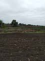
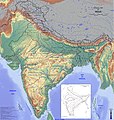
The Deccan Plateau, also known as the Peninsular Plateau or the Great Peninsular Plateau, is a large plateau in India, making up the majority of the southern part of the country, ranging in elevation from 100 metres in the north to 1000 metres in the south. It is located between three mountain ranges and extends over eight Indian states. Its uplands make up a triangle nested within the familiar downward-pointing triangle of the Indian sub-continent's coastline. Large areas of the states of Maharashtra, Karnataka and Telangana and parts of Andhra Pradesh comprise the Deccan plateau. The name Deccan is an anglicised form of the Prakrit word dakkhin, itself derived from the Sanskrit word dákṣiṇa, meaning "south".
下位カテゴリ
このカテゴリに属する 6 個のサブカテゴリのうち、 6 個を表示しています。
B
D
M
P
S
V
カテゴリ「Deccan Plateau」にあるメディア
このカテゴリに属する 25 個のファイルのうち、 25 個を表示しています。
-
 Bailadila Hill.jpg 3,334 × 1,884;1.31メガバイト
-
 Bidri-ware tray inlaid with silver - IMJ 84.70.132.jpg 3,264 × 2,193;1.14メガバイト
-
 Boulders in Jamthi Kh. Village.jpg 3,120 × 4,160;1.57メガバイト
-
 Coastal India topographical.jpg 622 × 345;49キロバイト
-
 Deccan Carts. (12510418734).jpg 1,000 × 820;666キロバイト
-
 Deccan Plateau.png 2,015 × 2,160;6.29メガバイト
-
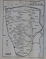
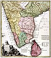 Deccan region, Malabar Coromandel Visapour Bisnagar Carnata Golconda 1733 CE.jpg 932 × 1,055;1.61メガバイト
-
 Deccan, India.png 4,724 × 4,960;29.58メガバイト
-
 Deccan.jpg 800 × 1,046;143キロバイト
-
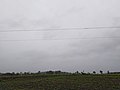 Dense clouds over Jamthi Kh..jpg 4,160 × 3,120;4.38メガバイト
-
 Emb Krishna.jpg 633 × 640;100キロバイト
-
 Ghadi Chowk, Bacheli.jpg 3,120 × 4,160;2.25メガバイト
-
 Ghat satellite view.jpg 639 × 639;155キロバイト
-
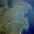 Godavari satellite view.jpg 5,248 × 5,248;8.05メガバイト
-
 Granite stones in Deccan.jpg 3,120 × 4,160;4.99メガバイト
-
 Male Mahadeshwara Hills Map.svg 840 × 666;486キロバイト
-
 Map of the Cities and Towns in the Deccan Plateau, India.png 2,362 × 3,543;9.05メガバイト
-
 NASA-GNT.jpg 640 × 633;100キロバイト
-
 Physical Map of India.jpg 4,724 × 4,960;7.68メガバイト
-
 Raichur Doab.jpg 482 × 639;156キロバイト
-
 Relief-Inde.png 522 × 600;189キロバイト
-
 Santa Maria feverfew in Jamthi Kh., India.jpg 3,120 × 4,160;5.63メガバイト
-

-
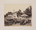
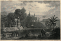 Views in India 0164.png 2,264 × 1,531;7.76メガバイト
-
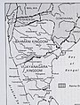
 Western Chalukya Empire (Kalyani) & the Kalachuris of Kalyani.jpg 3,496 × 4,540;2.88メガバイト


.jpg)


_(14802834913).jpg)

_%26_the_Kalachuris_of_Kalyani.jpg)