Category:Maps of White Sands National Park
Jump to navigation
Jump to search
United States national parks: Acadia · American Samoa · Arches · Badlands · Big Bend · Biscayne · Black Canyon of the Gunnison · Bryce Canyon · Canyonlands · Capitol Reef · Carlsbad Caverns · Channel Islands · Congaree · Crater Lake · Cuyahoga Valley · Death Valley · Denali · Dry Tortugas · Everglades · Gateway Arch · Gates of the Arctic · Glacier · Glacier Bay · Grand Canyon · Grand Teton · Great Basin · Great Smoky Mountains · Guadalupe Mountains · Haleakalā · Hawaii Volcanoes · Hot Springs · Indiana Dunes · Isle Royale · Joshua Tree · Kenai Fjords · Kings Canyon · Kobuk Valley · Lake Clark · Lassen Volcanic · Mammoth Cave · Mesa Verde · Mount Rainier · North Cascades · Olympic · Petrified Forest · Pinnacles · Redwood · Rocky Mountain · Saguaro · Sequoia · Shenandoah · Theodore Roosevelt · Virgin Islands · Voyageurs · White Sands · Wind Cave · Wrangell-St. Elias · Yellowstone · Yosemite · Zion
English: Maps of White Sands National Park
Wikimedia category | |||||
| Upload media | |||||
| Instance of | |||||
|---|---|---|---|---|---|
| Category combines topics | |||||
| White Sands National Park | |||||
national park in Otero and Doña Ana counties in New Mexico, United States  Vista aérea del campo de dunas | |||||
| Instance of | |||||
| Named after |
| ||||
| Location |
| ||||
| Visitor center | |||||
| Operator | |||||
| Heritage designation |
| ||||
| IUCN protected areas category | |||||
| Inception |
| ||||
| Part of the series | |||||
| Area |
| ||||
| Visitors per year |
| ||||
| Different from | |||||
| official website | |||||
 | |||||
Subcategories
This category has the following 2 subcategories, out of 2 total.
Media in category "Maps of White Sands National Park"
The following 12 files are in this category, out of 12 total.
-
 Dunes Drive in WSNM.png 691 × 817; 57 KB
-
 Map of White Sands National Monument.png 1,883 × 1,635; 349 KB
-
 Whitesandsmap.png 741 × 644; 117 KB
-
 NPS new-mexico-national-parks-map.jpg 459 × 518; 47 KB
-
 NPS white-sands-area-camping-map.jpg 1,288 × 1,167; 237 KB
-
 NPS white-sands-backcountry-camping-map.gif 1,092 × 574; 46 KB
-
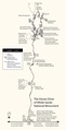
 NPS white-sands-dunes-drive-map.gif 1,166 × 2,282; 152 KB
-
 NPS white-sands-dunes-drive-map.pdf 1,750 × 3,422; 412 KB
-
 NPS white-sands-map.jpg 3,400 × 2,042; 1.34 MB
-
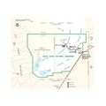
 NPS white-sands-national-monument-map.jpg 1,552 × 1,344; 271 KB
-
 NPS white-sands-national-monument-map.pdf 1,500 × 1,500; 818 KB
-
 NPS white-sands-regional-map.jpg 688 × 688; 127 KB


