Category:Rivers of the United States
Jump to navigation
Jump to search
Countries of North America: Barbados · Belize · Canada · Costa Rica · Cuba · Dominica · Dominican Republic · El Salvador · Guatemala · Haiti · Honduras · Jamaica · Mexico · Nicaragua · Panama · Trinidad and Tobago‡ · United States of America‡
Other territories: Greenland · Guadeloupe · Martinique · Puerto Rico
‡: partly located in North America
Other territories: Greenland · Guadeloupe · Martinique · Puerto Rico
‡: partly located in North America
States of the United States: Alabama · Alaska · Arizona · Arkansas · California · Colorado · Connecticut · Delaware · Florida · Georgia · Hawaii · Idaho · Illinois · Indiana · Iowa · Kansas · Kentucky · Louisiana · Maine · Maryland · Massachusetts · Michigan · Minnesota · Mississippi · Missouri · Montana · Nebraska · Nevada · New Hampshire · New Jersey · New Mexico · New York · North Carolina · North Dakota · Ohio · Oklahoma · Oregon · Pennsylvania · Rhode Island · South Carolina · South Dakota · Tennessee · Texas · Utah · Vermont · Virginia · Washington · West Virginia · Wisconsin · Wyoming – Washington, D.C.
Guam · Puerto Rico
Guam · Puerto Rico
Wikimedia list article | |||||
| Upload media | |||||
| Instance of | |||||
|---|---|---|---|---|---|
| |||||
Subcategories
This category has the following 41 subcategories, out of 41 total.
*
+
-
?
A
F
H
L
M
N
P
S
V
W
Media in category "Rivers of the United States"
The following 200 files are in this category, out of 206 total.
(previous page) (next page)-
 US map - rivers and lakes.png 1,584 × 1,224; 301 KB
-
 -Civil War View- MET DP248308.jpg 3,894 × 3,140; 1.91 MB
-
 -Civil War View- MET DP248313.jpg 3,753 × 2,955; 1.86 MB
-
 A segment of the new meandering channel.jpg 1,599 × 2,400; 220 KB
-

-
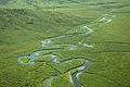 Aerial photography of river in green hills.jpg 2,100 × 1,397; 387 KB
-
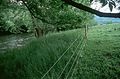 After fenced and seeded riverbank (1).jpg 3,000 × 1,979; 537 KB
-
 After fenced and seeded riverbank.jpg 3,000 × 1,979; 1.05 MB
-
 Almost spring time in mountains.jpg 2,100 × 1,400; 193 KB
-
 Along dead horse creek (ffd0b514f8aa4cd5bf0d5399c1cd245c).JPG 2,560 × 1,920; 2.39 MB
-
 Amazing river throu green fields.jpg 2,100 × 1,400; 90 KB
-
 Arial view of oil spill polution contaminants.jpg 3,000 × 1,965; 292 KB
-
 Artificial dam on river.jpg 2,000 × 1,312; 233 KB
-
 Ausable River.JPG 4,320 × 3,240; 5.49 MB
-
 Autumn vine maple (665050c0aff240cdb48d27fd9ecba522).JPG 2,560 × 1,920; 2.28 MB
-
 Beautiful landscape of the stream with vegetation around it.jpg 1,708 × 2,560; 338 KB
-
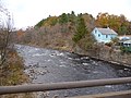
 Beautiful river landscape in the fall.jpg 1,244 × 827; 121 KB
-
 Beautiful river scenic in spring.jpg 2,100 × 1,382; 119 KB
-
 Beaver river landscape.jpg 1,050 × 702; 189 KB
-
-

-

-
 Blue skies with the sun offset to the right over a river in the morning.jpg 2,097 × 1,392; 82 KB
-
 Boulder Dash in Yellowstone River (49874902638).jpg 1,620 × 911; 2.43 MB
-
 Braided river and road scars in summer.jpg 2,100 × 1,366; 220 KB
-
 Braided river outwash plain.jpg 1,050 × 699; 116 KB
-
 Branches of juniper over Paradise River. (ea4866c309274c82a1dcd012840b3d9f).JPG 2,560 × 1,920; 2.4 MB
-
 Branciforte Creek.jpg 3,072 × 4,096; 4.1 MB
-
 Bridge across a river in Santa Clara, California. (8bfe5b9e69104bc4861d7f513bb849cb).jpg 7,970 × 5,343; 4.27 MB
-

-
 Bridge near Olympia, Washington, ca 1895 (WASTATE 1173).jpeg 768 × 570; 74 KB
-
 Bridge to Whitehouse, Wells - 4.jpg 5,781 × 3,854; 8.32 MB
-
 Buffalo River Floating.jpg 4,368 × 2,912; 4.59 MB
-
 Camp on the Skykomish River, Washington, ca 1892 (WASTATE 268).jpeg 768 × 455; 57 KB
-
 Chapel Branch from Chapel Branch Nature Preserve.jpg 3,264 × 2,448; 2.94 MB
-

-
 Clear Brook downstream of Hearns Pond.jpg 3,264 × 2,448; 3.03 MB
-
 Cloudy day at river shore.jpg 2,100 × 1,406; 157 KB
-
 Cold winter aerial scenic.jpg 3,000 × 2,000; 419 KB
-

-
 Controling erosion on lake.jpg 1,748 × 1,165; 82 KB
-
 Creek and bird.jpg 4,608 × 3,456; 8 MB
-
 Creek at september.jpg 1,244 × 827; 191 KB
-
 Creek in national reserve.jpg 2,100 × 1,404; 150 KB
-

-
 Creek meanders through the desert.jpg 2,400 × 3,600; 987 KB
-

-
 Creek scenic river landscape.jpg 2,100 × 1,404; 143 KB
-
 Creek wildlife scenics.jpg 1,244 × 827; 150 KB
-
 Delta (fiume, Alaska) - Percorso.png 610 × 626; 860 KB
-
 Delta swamps scenic.jpg 2,100 × 1,414; 109 KB
-
 Dewatto-River-estuary-Dewatto-Road-17-Aug-2017.jpg 4,608 × 3,456; 5.8 MB
-
 East branch greenlaw brook.jpg 3,665 × 2,400; 824 KB
-
 East fork river in brooks range winter scenic.jpg 2,100 × 1,366; 154 KB
-
 East Wacker Drive & Chicago River, Chicago (5946044279).jpg 4,000 × 3,000; 4.65 MB
-
 East Wacker Drive & Chicago River, Chicago (5946597306).jpg 4,000 × 3,000; 5.11 MB
-
 East Wacker Drive & Chicago River, Chicago (5946613576).jpg 3,008 × 2,000; 3.82 MB
-
 Edisto River - panoramio.jpg 3,072 × 2,304; 3.57 MB
-
 Endangered mussel habitat.jpg 4,024 × 2,700; 481 KB
-

-
 Everett Water Works, Everett, Washington, ca 1906 (WASTATE 952).jpeg 768 × 535; 99 KB
-
 Fall tree (4132358836).jpg 3,840 × 2,880; 10.87 MB
-
 Fast falls river.jpg 1,732 × 2,625; 218 KB
-
 Fast mountain river flowing through the conifer forest.jpg 3,625 × 2,400; 767 KB
-
 Fast river thru canyon.jpg 2,100 × 1,400; 255 KB
-
 Flickr - The U.S. Army - Row your boat.jpg 1,103 × 735; 741 KB
-
 FMIB 35721 Typical Salmon-Spawning Riffle.jpeg 885 × 580; 84 KB
-
 FMIB 36660 Hatching site, Wingecarribee River.jpeg 1,528 × 1,037; 723 KB
-
 FMIB 49469 "Lorna Doone's Brook".jpeg 745 × 1,105; 232 KB
-
 FMIB 49477 "An encourager of indolence".jpeg 754 × 1,227; 182 KB
-
 Fortyfive miles south of north hather creek.jpg 2,100 × 1,392; 195 KB
-

-
 GoldBranch2CRNRAFeb262012.jpg 2,581 × 1,921; 2.17 MB
-
 Goosefare creek swamp.jpg 1,750 × 1,312; 104 KB
-

-
-
 Hammonassett River Trail - Madison.jpg 1,936 × 2,592; 2.49 MB
-
 Herring Creek Floating Dock.jpg 3,840 × 1,920; 2.33 MB
-
 HFCA 1607 People Volume 1 324.jpg (e0304446a34b49599846b3b8d972909e).jpg 7,812 × 5,280; 2.67 MB
-
 HFCA 1607 People Volume 1 326.jpg (d55034c0e1ce47b0a3d0bd9634ddd7e3).jpg 7,812 × 5,280; 3.44 MB
-

-

-

-
 Ice cave entrance and creek. slide (244e451ca57a487083d2b3c0d821fd2d).jpg 2,168 × 1,479; 849 KB
-
-
 Lau 000405 169109 513011 4578 (36792948782).jpg 1,920 × 1,280; 1.23 MB
-

-
 Little Creek looking downstream from DE 9 bridge in 2008.jpg 3,264 × 2,448; 1.61 MB
-
 Log jam on the Humptulips River, Washington, 1909 (INDOCC 377).jpg 768 × 568; 101 KB
-
 Log jam on the Humptulips River, Washington, 1909 (INDOCC 536).jpg 768 × 552; 132 KB
-

-
-

-
 Logging crew, Deep River, Washington, 1903 (INDOCC 226).jpg 768 × 561; 154 KB
-
 Logging crew, Deep River, Washington, 1904 (INDOCC 371).jpg 768 × 593; 112 KB
-

-

-

-
 Man Stands near the confluence of the Swift and Dead Diamond Rivers.jpg 3,264 × 2,448; 2.61 MB
-
 Monkey flower with buds along creek. (69b5a468b1c64382bea3565c4b1cc70f).JPG 2,816 × 2,112; 2.45 MB
-
 Monkey flower with buds along creek. (c508111842154b1397cb2d8583d94e4f).JPG 1,972 × 2,670; 1.97 MB
-

-

-
 Moraines and debris below Nisqually Glacier (c3a9885b1f7d464fa8df950f6c8fadd4).JPG 2,560 × 1,920; 2.42 MB
-
 Moss (ce7d05830fc34aad955edd40a6e88d75).JPG 3,072 × 2,304; 1.7 MB
-
 Mossy Channel (5264886933).jpg 5,569 × 3,341; 8.45 MB
-
-
 Mt Rainier (c66059e0bd3f4f21b102e80a7973d8dd).JPG 2,560 × 1,920; 2.41 MB
-

-

-
 Natural Gas Vent (7238234930).jpg 4,592 × 3,056; 3.98 MB
-

-
 Nisqually lateral moraine and Nunitak (629271252e0743ebadbe883c6c82ff8f).JPG 2,560 × 1,920; 2.43 MB
-
 Nisqually River and rocks (7c3f69b50a554376bc817cf4505413bc).JPG 2,560 × 1,920; 2 MB
-
-
 Oak orchard creek.jpg 2,250 × 1,506; 242 KB
-
 Opal creek wilderness.jpg 1,536 × 2,048; 262 KB
-
 Outside MORA. 31981. slide (4c73ca794b2447cc881010ba01353552).jpg 2,140 × 1,457; 642 KB
-
 Outside MORA. 31981. slide (8a8725c498784cff88e26a0de7bef004).jpg 2,140 × 1,457; 634 KB
-
 Paradise River (048b7830c25846bf8f0a74b96000a5ab).JPG 2,816 × 2,112; 2.27 MB
-
 Paradise River (61faba04afb14684a8edff1b3a2ffe42).JPG 2,560 × 1,920; 2.36 MB
-

-
 Paradise River cascades (7f8c775220c148ec8cf85f31ca5523d6).JPG 2,560 × 1,920; 2.39 MB
-
 Paradise River Sluiskin branch (ce10a44fb31e4fe69f7cf82d8d9ce356).JPG 2,560 × 1,920; 2.18 MB
-

-
 Pendleton Creek, typical scene along the highways in Georgia (8367054145).jpg 1,500 × 985; 989 KB
-
 Photos-OutdoorImage-AdobeStock-IslandFord(11).jpg 1,936 × 2,581; 6.2 MB
-
 Photos-OutdoorImage-AdobeStock-IslandFord(4).jpg 2,581 × 1,936; 4.74 MB
-
 Plaskett creek campground.jpg 2,272 × 1,704; 274 KB
-

-

-

-

-

-

-
 Prosser Falls, Prosser, Washington, 1894 (WASTATE 126).jpeg 768 × 601; 81 KB
-
 Prosser on the Yakima River, Washington, ca 1902 (WASTATE 954).jpeg 768 × 611; 71 KB
-
 Quilcene River, Washington, ca 1898-1899 (WASTATE 2554).jpeg 737 × 491; 54 KB
-
 Rainbow River.jpg 4,656 × 2,620; 4.18 MB
-

-
 River (2153293236).jpg 2,816 × 1,584; 3.25 MB
-
 River bed (bb753d33f25b4cd8913a71a4730358a8).JPG 2,560 × 1,920; 2.36 MB
-
 River channel improvement, barge unloading at Gulf Refining Company - NARA - 280795.jpg 3,000 × 1,779; 1.22 MB
-
 River habitat (8425302718).jpg 639 × 427; 48 KB
-
 River scene. (10676148735).jpg 5,999 × 4,852; 1.28 MB
-
 River scene. (10676212244).jpg 6,015 × 4,859; 1.09 MB
-
 River scene. (10676417043).jpg 6,010 × 4,839; 1.35 MB
-

-
 River, trees and mountains (AL+CA 4286).jpg 355 × 600; 23 KB
-

-

-

-

-
-
 Scow fish wheel, Columbia River, Washington, ca 1920 (INDOCC 181).jpg 768 × 643; 115 KB
-
 Seymour Peak and marsh (f52c6df4dac845fcbbbd0b3a480ec2bd).JPG 2,560 × 1,920; 2.23 MB
-
 Shallow rocky creek in mountain.jpg 3,626 × 2,400; 860 KB
-
 Shoshone 02.jpg 5,132 × 3,421; 3.06 MB
-
 Shoshone 03.jpg 5,132 × 3,421; 2.96 MB
-
 Side channel of river (21b18bafbf3744b59190f011d5d9461e).JPG 2,560 × 1,920; 2.46 MB
-
 Slide (cd9d7ed3762149269ab695712459cb23).jpg 2,140 × 1,457; 1.03 MB
-

-
 Spring Creek Concession - NARA - 280993.jpg 3,000 × 1,760; 794 KB
-

-

-

-

-
 Stillwater river nature habitat.jpg 2,048 × 1,536; 327 KB
-
 Stream (93dd281a92e744a09094d459ab0b8601).JPG 2,868 × 2,110; 1.66 MB
-

-
 Subalpine daisy (86d7ad42c2c04425b23aa3da01e496a0).JPG 2,560 × 1,920; 1.88 MB
-

-
 Sunset (282146e057304ea8b626f4d53ccd7940).JPG 2,560 × 1,920; 1.22 MB
-
 Swamp or overflow of river - NARA - 528193.jpg 3,000 × 1,355; 1.56 MB
-
 Sweetwater Creek (Chattahoochee River) 2013.JPG 3,456 × 2,304; 4.94 MB
-
 Tahuya-estuary-North-Shore-bridge-17-Aug-2017.jpg 4,608 × 3,456; 4.09 MB
-
 Tannery Brook from Tinker Street.jpg 3,024 × 4,032; 4.2 MB
-
 Terminus of glacier and start of White River. (7d4880ce52444203921ec2241df6a04c).JPG 2,816 × 2,112; 2.36 MB
-
 The American angler (1896) (17490825593).jpg 2,788 × 1,600; 1.8 MB
-
-
 The world's highest bridge, spanning the top of the Royal Gorge. (7725168590).jpg 964 × 1,500; 1.16 MB
-

-

-

-
 Unloading a Barge on the Hooghly River (BOND 0097).jpeg 750 × 1,011; 148 KB
-
 Unloading Bricks on the Hooghly River (BOND 0095).jpeg 1,003 × 750; 144 KB
-
 US States Riverine Borders.jpg 974 × 723; 103 KB
-
 US-AerialPhotograph-20140311 203549 v1.JPG 4,608 × 2,592; 2.17 MB
-
 USRivers Contig48.png 2,560 × 1,440; 3.22 MB
-
 Vessels on river - NARA - 529184.jpg 3,000 × 2,368; 1.55 MB
-

-

-

-
 Visitor waterskiing behind a boat. (d32620dd70ae4d9e82b307603769c376).jpg 7,896 × 5,235; 729 KB
-
 Wagons at camp along river - NARA - 530046.jpg 3,000 × 2,341; 1.59 MB
-
 Watershed nhd2.png 1,155 × 672; 1.76 MB
-

-
-

-


_visible._No_EOC_near_Nisqually_River._3_(be58760cef5841beaf342a1c73e06f3b).jpg)

.jpg)


.JPG)


.JPG)


.jpeg)
.jpeg)
.jpeg)

.jpg)


.JPG)

.jpg)

.jpeg)


.jpeg)

.jpeg)


.jpeg)


.jpeg)

.jpg)


_-_Percorso.png)


.jpg)
.jpg)
.jpg)


.JPG)
.jpeg)
.jpg)


.jpeg)


.jpeg)


.jpg)
.jpg)
.jpeg)
.JPG)
.JPG)
.jpg)
.jpeg)
.jpg)

.jpg)
.jpg)
.jpg)
.jpg)
.jpg)
.jpg)
.jpg)
.jpeg)
.JPG)
.jpeg)

.JPG)
.JPG)
.jpeg)
.jpeg)
.JPG)
.JPG)
.jpg)
.jpeg)
.JPG)
.jpg)
.jpeg)
.jpg)
.jpeg)
.JPG)
.JPG)


.jpg)
.jpg)
.JPG)
.JPG)
.jpeg)
.JPG)
.JPG)
.jpg)
.jpg)
.jpg)
.jpg)

.jpeg)
.jpeg)
.jpeg)
.jpeg)
.jpg)
.jpeg)
.jpeg)
.jpeg)

.jpeg)
.jpg)
.JPG)

.jpg)
.jpg)
.jpg)
.jpg)
.jpeg)
.jpg)
.jpg)
.JPG)
.jpeg)
.jpg)
.JPG)


.JPG)
.jpg)
.jpg)


.JPG)
.jpeg)
.JPG)
.jpg)
.JPG)

_2013.JPG)


.JPG)
_(17490825593).jpg)
_-_its_habits,_habitat,_haunts,_and_characteristics_-_how,_when,_and_where_to_hunt_it_(1890)_(20625225571).jpg)
.jpg)
.jpeg)
.jpeg)
.jpg)
.jpeg)
.jpeg)


.jpg)
.jpg)
.jpg)
.jpg)


.jpg)
.jpg)
.jpeg)
.jpg)
.jpeg)
.jpg)
.jpg)
.jpg)
.jpg)
.jpg)
.jpg)