File:时局图.jpg

Originaldatei (3.915 × 5.532 Pixel, Dateigröße: 4,27 MB, MIME-Typ: image/jpeg)
Bildtexte
Kurzbeschreibungen
Beschreibung
[Bearbeiten]| Beschreibung |
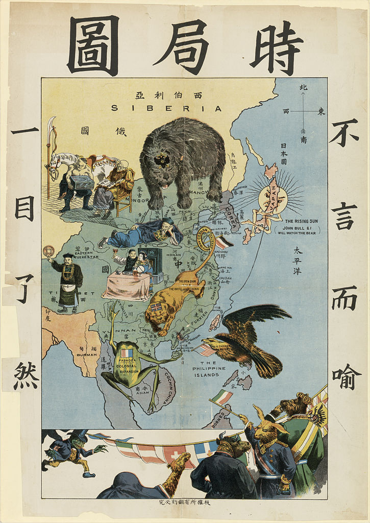
English: Newer version of THE SITUATION IN THE FAR EAST (時局圖). Its author (Tse Tsan-tai, 1872-1939) depicted the western powers encroaching on China at the end of the nineteenth century in symbolic form. At the left "to be clear at a glance" (一目了然), at the right, "self-evident" (不言而喻). The bear representing Russia is intruding from the north, the bulldog head with a lion body representing the United Kingdom is in south China, with its tail around the Shantung peninsula (Wehai english colony was the seat of the British bulldog in the first version of the cartoon), the Gallic frog, is in southeast Asia, with an inscription "Fashoda", in reference to Fashoda Incident opposing Britain and France in Africa. The frog has the Hainan Island in its right hand, in reference to Guangzhouwan, and part of the Sichuan in its left hand. The bald eagle representing the United States is approaching from the Philippines (the U.S. had already invaded the Philippines at this time). On the eagle is written "Blood is thicker than water", a reference to U.S. Navy Commodore Josiah Tattnall's saying in 1859. The symbolic Sun behind Japan spreads its rays across Korea onto China, while Japan fishes for Taiwan. Qing Amban is on Tibet and chinese teacher on Mongolia and Xinjiang with turco-mongol man. Some other European countries, following Prussia, are waiting to invade China at the bottom of the map.
Français : Nouvelle édition de « Carte de la situation politique » ( 時局圖 ), avec sur le coté gauche, « qu'on saisit à première vue » (一目了然 ) et à droite, « Cela va sans dire » (不言而喻 ). L'auteur (Tse Tsan-tai, 1872-1939) l'utilise pour exprimer l'invasion des puissances occidentale à la fin du XIXe siècle. L'ours représente la Russie au Nord, Le bulldog britannique (dessiné avec un corps de lion dont la queue entoure la Péninsule du Shandong, où se situait la colonie Britannique de Weihai), le Royaume-Uni au Sud-Est, la grenouille (vision britannique de la France), avec l'inscription Fashoda (en référence à la Crise de Fachoda, fashoda incident en anglais, opposant Britanniques et Français en Afrique), au Sud, venant d'Indochine (alors colonie française). La grenouille tient de la main droite l'île de Hainan, en référence à la possession de Kouang-Tchéou-Wan et la main gauche sur une partie du Sichuan. La Pygargue représente les États-Unis au dessus des Philippines qu'ils avaient à cette époque envahi. Le soleil du Japon caché sous derrière le pays envoie quelques rayons vers un fumeur d'opium chinois, allongé au milieu de la carte, tout en tenant d'un lasso Taïwan. Un Amban des Qing est au Tibet et un enseignant chinois, est sur la zone des turco-mongols (appelés Tartares par les européens) de Mongolie et du Xinjiang. Quelques autre pays font la queue pour envahir la Chine (en dessous de la carte) ; Prusse, suivie par d'autres pays européens, Empire austro-hongrois, Italie, Suisse... |
|||||||
| Datum |
English: Around 1900-1904. |
|||||||
| Quelle |
|
|||||||
| Urheber |
中文:原作者:謝纘泰 |
|||||||
| Genehmigung (Weiternutzung dieser Datei) |
|
|||||||
| Andere Versionen | Image:Politcal Map of 19th Century China(時局全圖).jpg(原裝版《時局圖》) , File:Bu yan-er yu yi mu liao-ran.jpg |


_by_(Tse_Tsan-tai,_1872-1939)_depicted_the_western_powers_encroaching_on_China,_%E6%97%B6%E5%B1%80%E5%9B%BE_(cropped).jpg)
Ursprüngliches Datei-Logbuch
[Bearbeiten]
(All user names refer to zh.wikipedia)
Dateiversionen
Klicke auf einen Zeitpunkt, um diese Version zu laden.
| Version vom | Vorschaubild | Maße | Benutzer | Kommentar | |
|---|---|---|---|---|---|
| aktuell | 02:00, 8. Apr. 2014 | | 3.915 × 5.532 (4,27 MB) | Underlying lk (Diskussion | Beiträge) | improved quality |
| 02:29, 16. Jul. 2007 |  | 431 × 625 (86 KB) | Shizhao (Diskussion | Beiträge) | {{Information |Description=19世纪末列强在华势力范围划分图 == 许可协议 == 作者:zh:謝纘泰(1872年5月16日 - 1939年4月6日) |Source=Originally from [http://zh.wikipedia.org zh.wikipedia]; description page is/was [http://z |
Du kannst diese Datei nicht überschreiben.
Dateiverwendung
Die folgenden 2 Seiten verwenden diese Datei:
Globale Dateiverwendung
Die nachfolgenden anderen Wikis verwenden diese Datei:
- Verwendung auf en.wikipedia.org
- Verwendung auf fa.wikipedia.org
- Verwendung auf fr.wikipedia.org
- Verwendung auf ja.wikipedia.org
- Verwendung auf ko.wikipedia.org
- Verwendung auf nn.wikipedia.org
- Verwendung auf pt.wikipedia.org
- Verwendung auf www.wikidata.org
- Verwendung auf wuu.wikipedia.org
- Verwendung auf zh-classical.wikipedia.org
- Verwendung auf zh-yue.wikipedia.org
- Verwendung auf zh.wikipedia.org
- Verwendung auf zh.wikibooks.org
Metadaten
- Old maps of China
- Political cartoons
- 1900s maps
- Maps of French Indochina
- Russian Bear
- Personifications of France
- Personifications of the United States
- Drawings of frogs
- China invaders
- Manhua
- Old maps of the Qing Dynasty
- 20th-century satirical maps
- Anthropomorphic rabbits and hares
- Anthropomorphic camels
- Anthropomorphic bulls
- Bears acting as humans in art
- Frogs acting as humans in art
- Personifications of nations as animal
- Tse Tsan-tai