File:1947 Zhonghua Minguo Quantu.png
跳至導覽
跳至搜尋

預覽大小:800 × 526 像素。 其他解析度:320 × 210 像素 | 640 × 420 像素 | 1,024 × 673 像素 | 1,280 × 841 像素 | 3,044 × 2,000 像素。
原始檔案 (3,044 × 2,000 像素,檔案大小:13.79 MB,MIME 類型:image/png)
說明
說明
添加單行說明來描述出檔案所代表的內容
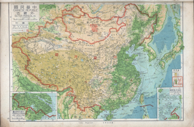
1947 map of the Republic of China and Outer Mongolia
| 描述 |
中文(简体):1947年出版的中华民国地图和外蒙古地图。图中的南海诸岛的名称仍使用旧称。1947年中华民国地图,此图中注明「外蒙古已经我国承认其独立」。此图中南海四沙仍然沿用旧名。
English: Map of the Chinese Republic and Outer Mongolia published in 1947. The names of the South China Sea Islands (Nanhai Zhudao) in the map still used old names. At the top of the map in 1947, which indicates that Outer Mongolia has been recognized for independence by the government of the Republic of China, and show the border between China and Mongolia. |
|||
| 日期 | ||||
| 來源 | https://www.nansha.org.cn/maps/3/1947_ROC_Map.jpg | |||
| 作者 | ||||
| 授權許可 (重用此檔案) |
|


檔案歷史
點選日期/時間以檢視該時間的檔案版本。
| 日期/時間 | 縮圖 | 尺寸 | 用戶 | 備註 | |
|---|---|---|---|---|---|
| 目前 | 2019年5月7日 (二) 02:18 | | 3,044 × 2,000(13.79 MB) | Tm(對話 | 貢獻) | Reverted to version as of 12:27, 6 May 2008 (UTC) |
| 2019年5月7日 (二) 00:12 |  | 1,600 × 1,119(3.35 MB) | Aerbaniya(對話 | 貢獻) | edit | |
| 2008年5月6日 (二) 12:27 |  | 3,044 × 2,000(13.79 MB) | Shibo77(對話 | 貢獻) | 中文说明: 为1947年出版的中华民国地图和南洋群岛图。图中的南海诸岛的名称仍使用旧称。1947年中华民国地图,此图中注明外蒙古已经被民国政府批准独立。此图中南海四沙仍然沿用旧名。 {{P |
無法覆蓋此檔案。
檔案用途
下列3個頁面有用到此檔案:
全域檔案使用狀況
以下其他 wiki 使用了這個檔案:
- ca.wikipedia.org 的使用狀況
- de.wikipedia.org 的使用狀況
- en.wikipedia.org 的使用狀況
- en.wiktionary.org 的使用狀況
- es.wikipedia.org 的使用狀況
- fr.wikipedia.org 的使用狀況
- id.wikipedia.org 的使用狀況
- ja.wikipedia.org 的使用狀況
- ko.wikipedia.org 的使用狀況
- mnw.wiktionary.org 的使用狀況
- no.wikipedia.org 的使用狀況
- sv.wikipedia.org 的使用狀況
- www.wikidata.org 的使用狀況
- zh-yue.wikipedia.org 的使用狀況
- zh.wikipedia.org 的使用狀況