File:Cilician Armenia-en.svg
Aller à la navigation
Aller à la recherche

Taille de cet aperçu PNG pour ce fichier SVG : 800 × 571 pixels. Autres résolutions : 320 × 228 pixels | 640 × 457 pixels | 1 024 × 730 pixels | 1 280 × 913 pixels | 2 560 × 1 826 pixels | 2 508 × 1 789 pixels.
Fichier d’origine (Fichier SVG, nominalement de 2 508 × 1 789 pixels, taille : 713 kio)
Légendes
Légendes
Ajoutez en une ligne la description de ce que représente ce fichier
Description
[modifier]| Description |
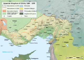
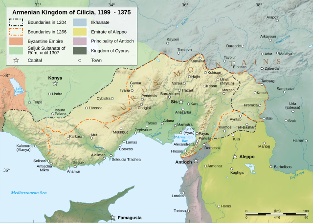
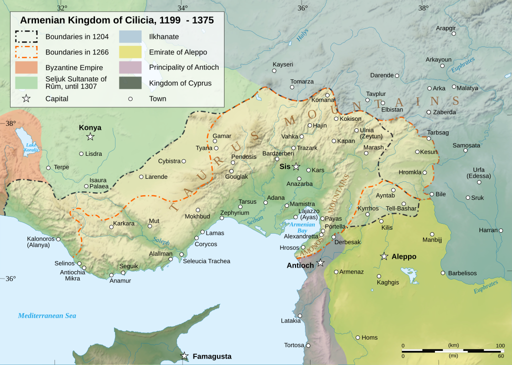
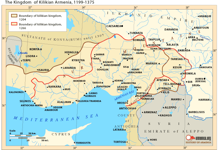
Čeština: Mapa Arménského království v Kilíkii v 13. století. Deutsch: Karte des Armenischen Königreichs von Kilikien während des 13. Jahrhunderts. English: Map of the Armenian Kingdom of Cilicia during the XIII century. Español: Mapa del siglo XIII del Reino armenio de Cilicia. Esperanto: Mapo de la Armena reĝlando en Kilikio dum la 13-a jarcento. Français : Carte en anglais du royaume de Petite Arménie (en Cilicie) au XIIIe siècle. Italiano: Mappa topografica del regno armeno di Cilicia durante il XIII secolo. Kapampangan: Metung a mapa ning Kaariang Armenian ning Cilicia aniang ka-XIII a dilanua o siglu. Magyar: A Kilikiai Örmény Királyság 13. századi állapotát mutató térkép. Nederlands: Engelstalige kaart van Cilicisch Armenië in de 13e eeuw. Polski: Mapa Armenii Małej w XIII wieku. Português: Mapa do Reino Armênio da Cilícia no século XIII. Svenska: En karta över det armeniska kungariket Kilikien under 1200-talet. Türkçe: 13. yüzyılda Kilikya Ermeni Krallığı'nın sınırları. Беларуская: Карта Кілійскага армянскага царства (13 ст.) Македонски: Карта на Ерменското кралство Киликија во XIII век. Հայերեն : Կիլիկիայի Հայկական Թագավորության քարտեզը 13րդ դարում. বাংলা : ত্রয়োদশ শতকের সিলিসিয়ার আর্মেনীয় রাজত্বের মানচিত্র। 한국어: 13세기 킬리키아 아르메니아 왕국의 지도 日本語: 13世紀のキリキア・アルメニア王国の地図。 中文(简体): 奇里乞亚亚美尼亚王国13世纪地图 中文(繁體): 奇里乞亞亞美尼亞王國13世紀地圖 العربية : خريطة لمملكة قيليقية الأرمينية خلال القرن الثالث عشر مازِرونی : نخشه پادشائی کلیسائ ارمنی قرن |
||||||||
| Date | |||||||||
| Source |
Travail personnel. English: Sources :
Software used :
Other data :
Français : Sources :
Logiciels utilisés :
Autres données :
|
||||||||
| Créé par | |||||||||
| Géoréférencement | Si c'est inapproprié, définissez warp_status = skip pour masquer. | ||||||||
| Autres versions |
[]
| ||||||||
| Attribution (imposé par la licence) | © Sémhur / Wikimedia Commons / | ||||||||
| Assessments |
|
||||||||
| SVG | Cette image vectorielle SVG a été créée avec Inkscape .
|
||||||||
| Graphic Lab |


| Lieu de la prise de vue | | Voir cet endroit et d’autres images sur : OpenStreetMap |
|---|
Conditions d’utilisation
[modifier]
Moi, en tant que détenteur des droits d’auteur sur cette œuvre, je la publie sous les licences suivantes :
| Copyleft : cette œuvre d’art est libre ; vous pouvez la redistribuer ou la modifier selon les termes de la licence Art Libre. Vous trouverez un exemplaire de cette licence sur le site Copyleft Attitude ainsi que sur d’autres sites. |
This file is licensed under the Creative Commons Attribution-Share Alike Attribution-Share Alike 4.0 International, 3.0 Unported, 2.5 Generic, 2.0 Generic and 1.0 Generic license.
- Vous êtes libre :
- de partager – de copier, distribuer et transmettre cette œuvre
- d’adapter – de modifier cette œuvre
- Sous les conditions suivantes :
- paternité – Vous devez donner les informations appropriées concernant l'auteur, fournir un lien vers la licence et indiquer si des modifications ont été faites. Vous pouvez faire cela par tout moyen raisonnable, mais en aucune façon suggérant que l’auteur vous soutient ou approuve l’utilisation que vous en faites.
- partage à l’identique – Si vous modifiez, transformez, ou vous basez sur cette œuvre, vous devez distribuer votre contribution sous la même licence ou une licence compatible avec celle de l’original.
Vous pouvez choisir l’une de ces licences.
Moi, en tant que détenteur des droits d’auteur sur cette œuvre, je la publie sous la licence suivante :

|
Vous avez la permission de copier, distribuer et modifier ce document selon les termes de la GNU Free Documentation License version 1.2 ou toute version ultérieure publiée par la Free Software Foundation, sans sections inaltérables, sans texte de première page de couverture et sans texte de dernière page de couverture. Un exemplaire de la licence est inclus dans la section intitulée GNU Free Documentation License. |
| Ce fichier est disponible selon les termes de la licence Creative Commons Attribution – Partage dans les Mêmes Conditions 3.0 (non transposée). | ||
| ||
| Ce bandeau de licence a été ajouté à ce fichier dans le cadre de la procédure de mise à jour des licences des images sous GFDL. |
Historique du fichier
Cliquer sur une date et heure pour voir le fichier tel qu'il était à ce moment-là.
| Date et heure | Vignette | Dimensions | Utilisateur | Commentaire | |
|---|---|---|---|---|---|
| actuel | 9 mars 2023 à 19:23 | | 2 508 × 1 789 (713 kio) | Ömer faruk çakmak (d | contributions) | File uploaded using svgtranslate tool (https://svgtranslate.toolforge.org/). Added translation for tr. |
| 9 mars 2023 à 18:29 |  | 2 508 × 1 789 (691 kio) | Ömer faruk çakmak (d | contributions) | File uploaded using svgtranslate tool (https://svgtranslate.toolforge.org/). Added translation for tr. | |
| 17 janvier 2008 à 10:58 |  | 2 508 × 1 789 (671 kio) | Sémhur (d | contributions) | Correcting few bugs (x2) | |
| 17 janvier 2008 à 10:55 |  | 2 508 × 1 789 (671 kio) | Sémhur (d | contributions) | Correcting few bugs | |
| 16 janvier 2008 à 19:42 |  | 2 508 × 1 789 (671 kio) | Sémhur (d | contributions) | heavier... Too bad | |
| 16 janvier 2008 à 19:33 |  | 2 508 × 1 789 (261 kio) | Sémhur (d | contributions) | bigger size, lighter weight, + coordinates | |
| 13 janvier 2008 à 11:38 |  | 1 458 × 991 (362 kio) | Sémhur (d | contributions) | == Description == {{Information |Description= {{en| Map of the Armenian Kingdom of Cilicia during the XIII century.}} {{fr| Carte en anglais du royaume de Petite Arménie (en Cilicie) au XIII<sup>ème</sup> siècle.}} |S |
Vous ne pouvez pas remplacer ce fichier.
Utilisations locales du fichier
Les 62 pages suivantes utilisent ce fichier :
- Atlas of Armenia
- Atlas of Turkey
- Atlas of the Levant
- User:Magog the Ogre/Multilingual legend/2023 March 1-10
- User:Miya/POTY/Diagrams2008
- User:Notafish/Votes 2008
- User:Sémhur
- User talk:Sting/Archive 01
- Commons:Featured picture candidates/Image:Cilician Armenia-en.svg
- Commons:Featured picture candidates/Log/January 2008
- Commons:Featured pictures/Non-photographic media/Maps
- Commons:Featured pictures/chronological/2008-A
- Commons:Picture of the Year/2008/Galleries/All
- Commons:Picture of the Year/2008/Galleries/Diagrams
- Commons:Picture of the Year/2008/Results/Round 1/Gallery/All
- Commons:Picture of the Year/2008/Results/Round 1/Gallery/Diagrams
- Commons:Picture of the Year 2008/File:Cilician Armenia-en.svg
- Commons:Potd/2010-03 (da)
- Commons:Potd/2010-03 (de)
- Commons:Potd/2010-03 (nl)
- Commons:Potd/2010-03 (pt)
- File:Armenianmeds.gif
- File:Cilician Armenia-ar.svg
- File:Cilician Armenia-cs.svg
- File:Cilician Armenia-en.svg
- File:Cilician Armenia-fr.svg
- File:Cilician Armenia-hu.svg
- File:Cilician Armenia-it.svg
- File:Cilician Armenia-sv.svg
- Template:Other versions/Cilician Armenia
- Template:Potd/2010-03
- Template:Potd/2010-03-04
- Template:Potd/2010-03-04 (ar)
- Template:Potd/2010-03-04 (be)
- Template:Potd/2010-03-04 (bn)
- Template:Potd/2010-03-04 (ca)
- Template:Potd/2010-03-04 (cs)
- Template:Potd/2010-03-04 (da)
- Template:Potd/2010-03-04 (de)
- Template:Potd/2010-03-04 (en)
- Template:Potd/2010-03-04 (eo)
- Template:Potd/2010-03-04 (es)
- Template:Potd/2010-03-04 (fr)
- Template:Potd/2010-03-04 (hu)
- Template:Potd/2010-03-04 (hy)
- Template:Potd/2010-03-04 (it)
- Template:Potd/2010-03-04 (ja)
- Template:Potd/2010-03-04 (ko)
- Template:Potd/2010-03-04 (mk)
- Template:Potd/2010-03-04 (mzn)
- Template:Potd/2010-03-04 (nl)
- Template:Potd/2010-03-04 (pam)
- Template:Potd/2010-03-04 (pl)
- Template:Potd/2010-03-04 (pt)
- Template:Potd/2010-03-04 (ru)
- Template:Potd/2010-03-04 (sv)
- Template:Potd/2010-03-04 (uk)
- Template:Potd/2010-03-04 (zh-hans)
- Template:Potd/2010-03-04 (zh-hant)
- Template:Potd/2010-03 (zh-hans)
- Category:Armenian Kingdom of Cilicia
- Category:Armenian Kings of Cilicia
Utilisations du fichier sur d’autres wikis
Les autres wikis suivants utilisent ce fichier :
- Utilisation sur als.wikipedia.org
- Utilisation sur an.wikipedia.org
- Utilisation sur arz.wikipedia.org
- Utilisation sur ast.wikipedia.org
- Utilisation sur azb.wikipedia.org
- Utilisation sur az.wikipedia.org
- Utilisation sur ba.wikipedia.org
- Utilisation sur be.wikipedia.org
- Utilisation sur bg.wikipedia.org
- Utilisation sur bn.wikipedia.org
- Utilisation sur ca.wikipedia.org
- Utilisation sur crh.wikipedia.org
- Utilisation sur cs.wikipedia.org
- Utilisation sur cv.wikipedia.org
- Utilisation sur de.wikipedia.org
- Utilisation sur el.wikipedia.org
- Utilisation sur en.wikipedia.org
- Cilicia
- History of Armenia
- List of monarchs of the Armenian Kingdom of Cilicia
- Hethum II
- Leo I, King of Armenia
- Rumkale
- Armenian Kingdom of Cilicia
- Toros Roslin
- Armenian illuminated manuscripts
- Portal:Maps/Maps/Political
- Portal:Maps/Maps/Political/12
- Second Battle of Sarvandik'ar
- Wikipedia:Wikipedia Signpost/2012-04-30/WikiProject report
- Wikipedia:Wikipedia Signpost/Single/2012-04-30
- Wikipedia:Featured picture candidates/May-2013
- Wikipedia:Featured picture candidates/Cilician Armenia
- Talk:Armenia/Archive 9
- Zayn al-Din Qaraja
- Ghars al-Din Khalil
- Ibrahim I of Ramadan
- User:Falcaorib/Medieval Empires (1300-1500 AD)
- Utilisation sur en.wiktionary.org
Voir davantage sur l’utilisation globale de ce fichier.
Métadonnées
Catégories :
- Maps of Cilicia
- Maps of the Armenian Kingdom of Cilicia
- SVG maps of the history of Armenia
- Maps of the history of Turkey
- Maps of the history of Syria
- Maps showing 12th-century history
- Maps showing 13th-century history
- Maps showing 14th-century history
- Topographic maps of the Middle East
- English-language SVG maps showing history