File:Europe 814.svg
Ir a la navegación
Ir a la búsqueda

Tamaño de esta previsualización PNG del archivo SVG: 800 × 526 píxeles. Otras resoluciones: 320 × 210 píxeles | 640 × 420 píxeles | 1024 × 673 píxeles | 1280 × 841 píxeles | 2560 × 1682 píxeles | 1399 × 919 píxeles.
Archivo original (archivo SVG, nominalmente 1399 × 919 píxeles, tamaño de archivo: 3,4 MB)
Leyendas
Leyendas
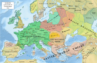
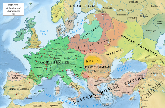
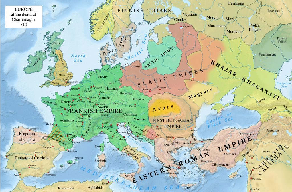
Ubicación de los imperios de la edad media
Resumen
[editar]| Descripción |
English: An svg version of File:Europe 814.jpg with corrections.
List of corrections:
|
| Fecha | |
| Fuente | "The Public Schools Historical Atlas" by Charles Colbeck. Longmans, Green; New York; London; Bombay. 1905. |
| Autor | Hel-hama |
| Otras versiones |
|


_en.png)
.png)
.jpg)
Licencia
[editar]
Yo, el titular de los derechos de autor de esta obra, la publico en los términos de la siguiente licencia:
Este archivo se encuentra bajo la licencia Creative Commons Genérica de Atribución/Compartir-Igual 3.0.
- Eres libre:
- de compartir – de copiar, distribuir y transmitir el trabajo
- de remezclar – de adaptar el trabajo
- Bajo las siguientes condiciones:
- atribución – Debes otorgar el crédito correspondiente, proporcionar un enlace a la licencia e indicar si realizaste algún cambio. Puedes hacerlo de cualquier manera razonable pero no de manera que sugiera que el licenciante te respalda a ti o al uso que hagas del trabajo.
- compartir igual – En caso de mezclar, transformar o modificar este trabajo, deberás distribuir el trabajo resultante bajo la misma licencia o una compatible como el original.
Este archivo está en el dominio público en los Estados Unidos. Esto se aplica a los trabajos de Estados Unidos donde los derechos de autor han expirado, a menudo porque su primera publicación ocurrió antes del 1 de enero de 1929. Véase esta página para explicación adicional.
|
 | |
 |
_(St_Edwards_Crown).svg)
|
This file is licensed under the Open Government Licence version 1.0 (OGL v1.0).
|
|---|---|
|
You are free to:
See the Open Government Licence page on Meta-Wiki for more information.
|
This work is in the public domain in India because its term of copyright has expired.
The Indian Copyright Act applies in India to works first published in India. According to the Indian Copyright Act, 1957, as amended up to Act No. 27 of 2012 (Chapter V, Section 25):
|
 |
Historial del archivo
Haz clic sobre una fecha y hora para ver el archivo tal como apareció en ese momento.
| Fecha y hora | Miniatura | Dimensiones | Usuario | Comentario | |
|---|---|---|---|---|---|
| actual | 20:05 8 ene 2023 | | 1399 × 919 (3,4 MB) | Miki Filigranski (discusión | contribs.) | correction of Bosnian border, which was a separate land according to modern scholarship, contested but never completelly under Serbian or Croatian control |
| 21:32 29 nov 2022 |  | 1399 × 919 (3,39 MB) | Gyalu22 (discusión | contribs.) | Added Avar ethnic territory, see Bulgarians_and_Slavs_VI-VII_century.png. Also extended Magyar ethnic territory to Bessarabia | |
| 10:26 1 nov 2022 |  | 1399 × 919 (3,38 MB) | Miki Filigranski (discusión | contribs.) | Reverted to version as of 07:20, 31 July 2022 (UTC) | |
| 04:47 3 ago 2022 |  | 1399 × 919 (3,38 MB) | Bernd21t (discusión | contribs.) | (resumen de edición eliminado) | |
| 07:20 31 jul 2022 |  | 1399 × 919 (3,38 MB) | Miki Filigranski (discusión | contribs.) | Reverted to version as of 16:51, 27 March 2022 (UTC) | |
| 05:13 18 jul 2022 |  | 1399 × 919 (3,38 MB) | Ionelen (discusión | contribs.) | Reverted to version as of 19:41, 13 April 2022 (UTC) | |
| 07:41 12 jul 2022 |  | 1399 × 919 (3,38 MB) | Ahmet Q. (discusión | contribs.) | Reverted to version as of 16:51, 27 March 2022 (UTC) | |
| 19:41 13 abr 2022 |  | 1399 × 919 (3,38 MB) | Wojsław12 (discusión | contribs.) | Reverted to version as of 11:43, 14 January 2022 (UTC) | |
| 16:51 27 mar 2022 |  | 1399 × 919 (3,38 MB) | Silverije (discusión | contribs.) | Reverted to version as of 12:43, 1 June 2021 (UTC) | |
| 11:43 14 ene 2022 |  | 1399 × 919 (3,38 MB) | TómasdeAquino2 (discusión | contribs.) | Corrected POV issues of blocked sock of Crovata Miki Filigranski |
No puedes sobrescribir este archivo.
Usos del archivo
Las siguientes páginas usan este archivo:
- Atlas of European history
- Atlas of the Middle Ages
- User:+JMJ+/gallery
- User:Est. 2021/Gallery/Kievan Rus
- User:J budissin/Uploads/BiH/2016 June 1-10
- User:J budissin/Uploads/BiH/2016 June 21-30
- User:J budissin/Uploads/BiH/2016 March 11-20
- User:J budissin/Uploads/BiH/2019 October 11-20
- User:One2/Mapas subidos
- User:Zinneke/Nei Biller iwwer Lëtzebuerg/2020 December 21-31
- User:Zinneke/Nei Biller iwwer Lëtzebuerg/2020 May 11-20
- User:Zinneke/Nei Biller iwwer Lëtzebuerg/2020 September 11-20
- User:Zinneke/Nei Biller iwwer Lëtzebuerg/2021 June 1-10
- User:Zinneke/Nei Biller iwwer Lëtzebuerg/2022 August 1-10
- User:Zinneke/Nei Biller iwwer Lëtzebuerg/2022 July 11-20
- File:Balkans in the 9th century.png
- File:Europe 814-it.svg
- File:Europe 814.png
Uso global del archivo
Las wikis siguientes utilizan este archivo:
- Uso en af.wikipedia.org
- Uso en ar.wikipedia.org
- Uso en arz.wikipedia.org
- Uso en bg.wikipedia.org
- Uso en bn.wikipedia.org
- Uso en ca.wikipedia.org
- Uso en cs.wikipedia.org
- Uso en cy.wikipedia.org
- Uso en de.wikipedia.org
- Uso en el.wikipedia.org
- Uso en en.wikipedia.org
- Charlemagne
- History of Europe
- Vikings
- 814
- History of Estonia
- Bulgars
- Principality of Serbia (early medieval)
- Saare County
- Early Middle Ages
- Kvenland
- Askold and Dir
- Duchy of Benevento
- Portal:Estonia
- Franks
- Višeslav of Serbia
- History of Christian thought on persecution and tolerance
- Borna (duke)
- Vlastimir
- Arab–Khazar wars
- Duchy of Gascony
- Muslim conquest of Sicily
- Prosigoj
- Rus' people
- Early Slavs
- Radoslav of Serbia
- Barbarian kingdoms
- Agriculture in the Middle Ages
- Gersuinda
- User:Falcaorib/Medieval Empires (800-1000 AD)
- User:Falcaorib/Europe
Ver más uso global de este archivo.