File:ISS-20 Thunderstorms on the Brazilian Horizon.jpg
Jump to navigation
Jump to search

Size of this preview: 800 × 531 pixels. Other resolutions: 320 × 213 pixels | 640 × 425 pixels | 1,024 × 680 pixels | 1,280 × 850 pixels | 2,560 × 1,700 pixels | 4,288 × 2,848 pixels.
Original file (4,288 × 2,848 pixels, file size: 3.82 MB, MIME type: image/jpeg)
Captions
Captions
Add a one-line explanation of what this file represents
Summary[edit]
| Description |
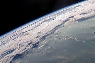
English: A picturesque line of thunderstorms and numerous circular cloud patterns filled the view as the International Space Station (ISS) Expedition 20 crew members looked out at the limb (blue line on the horizon) of the Earth.
|
| Date | Taken on 6 October 2009, 21:06:53 |
| Source | NASA Earth Observatory |
| Author | NASA Expedition 20 crew |
| Other versions |
|
.jpg)
| Camera location | | View this and other nearby images on: OpenStreetMap |
|---|
|
This image was selected as picture of the day on Wikimedia Commons for 22 April 2015. It was captioned as follows: English: On Earth Day, a photograph of the Earth's limb as seen from the International Space Station (ISS) on Northern Brazil, during the Expedition 20. The vegetation of Amazonia, the largest rainforest on Earth, strongly influences the regional water cycle. Other languages:
Bosanski: Na Dan planete Zemlje, fotografija ivice Zemlje sa Međunarodne svemirske stanice ISS. Vidljivo je područje sjevernog Brazila. Čeština: Při příležitosti dnešního Dne Země - fotografie severní části území Brazílie pořízená z Mezinárodní vesmírné stanice (ISS) v průběhu jubilejní 20. expedice. Vegetace Amazonského deštného pralesa je silně ovlivňována místními cykly transportu a pohybu vodních mas. Deutsch: Zum heutigen Tag der Erde ein Blick auf unseren Planeten von der Internationalen Raumstation aus. Zu sehen ist u.a. Nordbrasilien. English: On Earth Day, a photograph of the Earth's limb as seen from the International Space Station (ISS) on Northern Brazil, during the Expedition 20. The vegetation of Amazonia, the largest rainforest on Earth, strongly influences the regional water cycle. Español: En el Día de la Tierra, una fotografía de la Tierra desde la Estación Espacial Internacional (EEI) del norte de Brasil, en el ámbito de la Expedición 20. La vegetación de la Amazonía, la selva tropical más grande de la Tierra, influye fuertemente en el ciclo del agua regional. Italiano: Il Brasile settentrionale fotografato dalla Stazione Spaziale Internazionale durante la Expedition 20. Magyar: A Föld napján: Amazóniának, a Föld tüdejének látképe, a 20. expedíció alatt a Nemzetközi Űrállomásról nézve Nederlands: Foto van Noord-Brazilië vanuit het Internationaal ruimtestation ISS tijdens ISS Expeditie 20. Português: No Dia da Terra, uma fotografia da Região Norte do Brasil vista da Estação Espacial Internacional durante a Expedição 20. A vegetação da Amazônia, a maior floresta tropical da Terra, influencia fortemente o ciclo da água regional. |
This image or video was catalogued by Johnson Space Center of the United States National Aeronautics and Space Administration (NASA) under Photo ID: ISS020-E-47807. This tag does not indicate the copyright status of the attached work. A normal copyright tag is still required. See Commons:Licensing. Other languages:
|
Licensing[edit]
This file is in the public domain in the United States because it was created by the Image Science & Analysis Laboratory, of the NASA Johnson Space Center. NASA copyright policy states that "NASA material is not protected by copyright unless noted". (NASA media use guidelines or Conditions of Use of Astronaut Photographs).
Photo source: ISS020-E-47807.
|
| Annotations | This image is annotated: View the annotations at Commons |
File history
Click on a date/time to view the file as it appeared at that time.
| Date/Time | Thumbnail | Dimensions | User | Comment | |
|---|---|---|---|---|---|
| current | 23:15, 10 August 2014 | | 4,288 × 2,848 (3.82 MB) | Ras67 (talk | contribs) | new processed from NASA's raw image data, color temperature changed to 5800 K, contrast improved, grading adjusted, lens flares removed/mitigated and saved with highest JPEG quality |
| 14:54, 18 March 2010 |  | 4,288 × 2,848 (877 KB) | Tryphon (talk | contribs) | Losslessly cropped using jpegtran. | |
| 12:44, 9 November 2009 |  | 4,288 × 2,843 (1,007 KB) | Cropbot (talk | contribs) | upload cropped version, operated by User:Originalwana. Summary: cropped | |
| 12:38, 9 November 2009 |  | 4,288 × 2,929 (926 KB) | Originalwana (talk | contribs) | {{Information |Description={{en|1=A picturesque line of thunderstorms and numerous circular cloud patterns filled the view as the International Space Station (ISS) Expedition 20 crew members looked out at the limb ( |
You cannot overwrite this file.
File usage on Commons
The following 37 pages use this file:
- Featured Photographs in the Public Domain
- User:Beria/POTY per date
- User:Miya/POTY/2014
- User:Originalwana
- User:Zyephyrus/2015
- User talk:Ras67/Archive 3
- Commons:Featured picture candidates/File:ISS-20 Thunderstorms on the Brazilian Horizon.jpg
- Commons:Featured picture candidates/File:Thunderstorms on the Brazilian Horizon.jpg
- Commons:Featured picture candidates/Log/August 2014
- Commons:Featured picture candidates/Log/March 2010
- Commons:Featured pictures/Places/Satellite images
- Commons:Featured pictures/chronological/2014-B
- Commons:Picture of the Year/2014/Candidates
- Commons:Picture of the Year/2014/R1/Gallery/2014-B
- Commons:Picture of the Year/2014/R1/Gallery/ALL
- Commons:Picture of the Year/2014/R1/Gallery/Astronomy
- Commons:Picture of the Year/2014/R1/Gallery/M08
- Commons:Picture of the Year/2014/R1/Results/Astronomy, satellite and outer space
- Commons:Picture of the Year/2014/R1/Results/Candidates
- Commons:Picture of the Year/2014/R1/Results/Candidates/Astronomy, satellite and outer space
- Commons:Picture of the Year/2014/R1/v/ISS-20 Thunderstorms on the Brazilian Horizon.jpg
- File:Thunderstorms on the Brazilian Horizon.jpg (file redirect)
- File:Thunderstorms on the Brazilian Horizon (GOES).jpg
- Template:Potd/2015-04
- Template:Potd/2015-04-22
- Template:Potd/2015-04-22 (bs)
- Template:Potd/2015-04-22 (cs)
- Template:Potd/2015-04-22 (de)
- Template:Potd/2015-04-22 (en)
- Template:Potd/2015-04-22 (es)
- Template:Potd/2015-04-22 (hu)
- Template:Potd/2015-04-22 (it)
- Template:Potd/2015-04-22 (ko)
- Template:Potd/2015-04-22 (nl)
- Template:Potd/2015-04-22 (pt)
- Template:Potd/2015-04-22 (zh-hant)
- Template:Potd/2015-04 (zh-hans)
File usage on other wikis
The following other wikis use this file:
- Usage on ace.wikipedia.org
- Usage on be-tarask.wikipedia.org
- Usage on bn.wikipedia.org
- Usage on bn.wikibooks.org
- Usage on ce.wikipedia.org
- Usage on crh.wikipedia.org
- Usage on cv.wikipedia.org
- Usage on en.wikipedia.org
- Usage on fa.wikibooks.org
- Usage on he.wikipedia.org
- Usage on hu.wikipedia.org
- Usage on hy.wikibooks.org
- Usage on ka.wikipedia.org
- Usage on ko.wikipedia.org
- Usage on krc.wikipedia.org
- Usage on lbe.wikipedia.org
- Usage on mg.wikipedia.org
- Usage on os.wikipedia.org
- Usage on pt.wikipedia.org
- Usage on ru.wikipedia.org
- Usage on ru.wikinews.org
- Usage on sah.wikipedia.org
- Usage on sr.wikipedia.org
- Usage on su.wikipedia.org
- Usage on tt.wikipedia.org
- Usage on uk.wikipedia.org
- Usage on vi.wikipedia.org
- Usage on zh.wikipedia.org