File:Justinien 527-565.svg
跳至導覽
跳至搜尋

此 SVG 檔案的 PNG 預覽的大小:800 × 385 像素。 其他解析度:320 × 154 像素 | 640 × 308 像素 | 1,024 × 493 像素 | 1,280 × 616 像素 | 2,560 × 1,232 像素 | 1,810 × 871 像素。
原始檔案 (SVG 檔案,表面大小:1,810 × 871 像素,檔案大小:577 KB)
說明
說明
添加單行說明來描述出檔案所代表的內容
摘要
[編輯]
| 描述 |
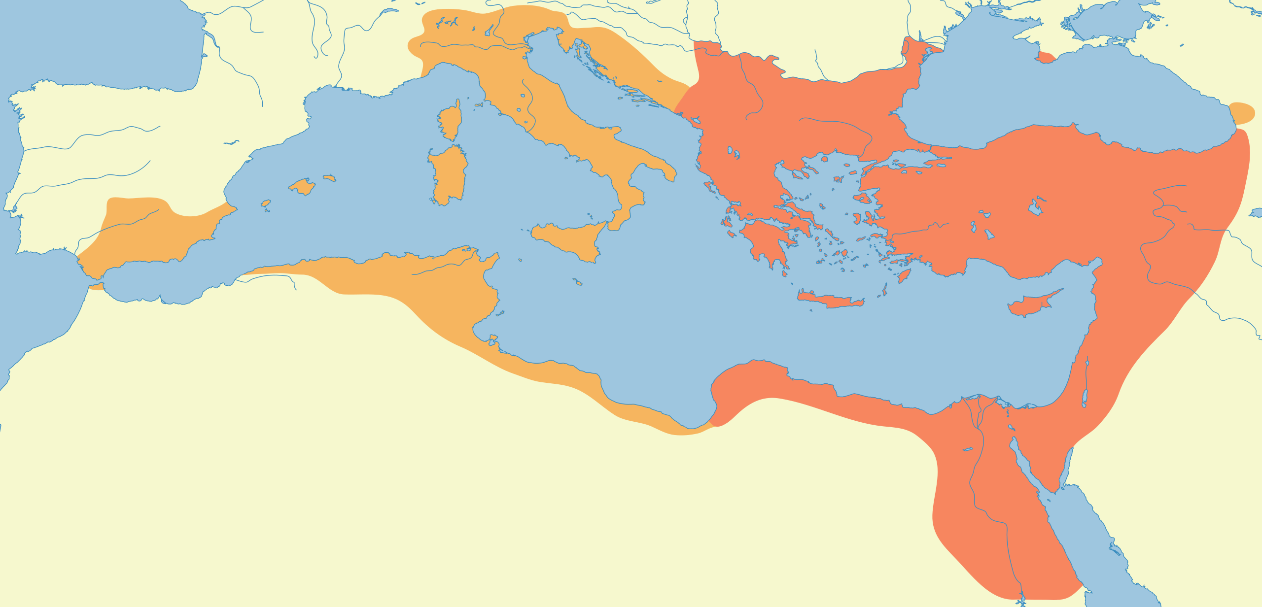
Français : L'empire byzantin à l'avènement de Justinien I (527 EC) et à sa mort (565 EC). Source : Georges Duby, Atlas historique Duby, 2002 (?), Larousse. .
English: The Byzantine empire at the advent of Justinian I to the throne (527 CE) and at his death (565 CE). Source: Georges Duby, Atlas historique Duby, 2002 (?) |
| 日期 | 2005年10月25日 (原始上傳日期) |
| 來源 | 无法识别来源。根据版权声明推断为其自己的作品。 |
| 作者 | 无法识别作者。根据版权声明推断作者为Neuceu。 |
| SVG開發 |
授權條款
[編輯]
我,本作品的著作權持有者,決定用以下授權條款發佈本作品:
此檔案採用創用CC 姓名標示-相同方式分享 2.5 通用版授權條款。
- 您可以自由:
- 分享 – 複製、發佈和傳播本作品
- 重新修改 – 創作演繹作品
- 惟需遵照下列條件:
- 姓名標示 – 您必須指名出正確的製作者,和提供授權條款的連結,以及表示是否有對內容上做出變更。您可以用任何合理的方式來行動,但不得以任何方式表明授權條款是對您許可或是由您所使用。
- 相同方式分享 – 如果您利用本素材進行再混合、轉換或創作,您必須基於如同原先的相同或兼容的條款,來分布您的貢獻成品。
derivative works
[編輯]
Derivative works of this file:
檔案歷史
點選日期/時間以檢視該時間的檔案版本。
| 日期/時間 | 縮圖 | 尺寸 | 使用者 | 備註 | |
|---|---|---|---|---|---|
| 目前 | 2019年6月19日 (三) 08:05 | | 1,810 × 871(577 KB) | Yann(留言 | 貢獻) | Reverted to version as of 08:23, 25 October 2005 (UTC) |
| 2019年6月16日 (日) 17:22 |  | 1,810 × 871(572 KB) | SuperSucker(留言 | 貢獻) | fix - date added | |
| 2005年10月25日 (二) 08:23 |  | 1,810 × 871(577 KB) | Neuceu(留言 | 貢獻) | L'empire de Justinien à l'avènement de Justinien (527) et à sa mort (565). The Byzantine empire of Justinian I in 527 and 565. Category:Maps of the Byzantine Empire |
無法覆蓋此檔案。
檔案用途
下列31個頁面有用到此檔案:
- Atlas of Albania
- Atlas of Bosnia and Herzegovina
- Atlas of Bulgaria
- Atlas of Croatia
- Atlas of Cyprus
- Atlas of Egypt
- Atlas of Greece
- Atlas of Israel
- Atlas of Italy
- Atlas of Jordan
- Atlas of Kosovo
- Atlas of Lebanon
- Atlas of Libya
- Atlas of Malta
- Atlas of Montenegro
- Atlas of North Macedonia
- Atlas of Northern Cyprus
- Atlas of Palestine
- Atlas of Serbia
- Atlas of Syria
- Atlas of Tunisia
- Atlas of Turkey
- Atlas of ancient Rome
- Atlas of the Byzantine Empire
- Atlas of the Middle Ages
- Belisarius
- Flavius Petrus Sabbatius Iustinianus
- User:J budissin/Uploads/BiH/2019 June 11-20
- File:ByzantineEmpireMap-cs-690's.png
- File:ByzantineEmpireMap-cs-842.png
- File:The Byzantine State under Justinian I-pt.svg
全域檔案使用狀況
以下其他 wiki 使用了這個檔案:
- af.wikipedia.org 的使用狀況
- als.wikipedia.org 的使用狀況
- ar.wikipedia.org 的使用狀況
- ast.wikipedia.org 的使用狀況
- azb.wikipedia.org 的使用狀況
- bg.wikipedia.org 的使用狀況
- bn.wikipedia.org 的使用狀況
- ca.wikipedia.org 的使用狀況
- cs.wikipedia.org 的使用狀況
- cy.wikipedia.org 的使用狀況
- da.wikipedia.org 的使用狀況
- de.wikipedia.org 的使用狀況
- el.wikipedia.org 的使用狀況
- en.wikipedia.org 的使用狀況
檢視此檔案的更多全域使用狀況。