File:Political map of India.svg

Original file (SVG file, nominally 1,594 × 1,868 pixels, file size: 342 KB)
Captions
Captions
Summary
[edit]
| Description |
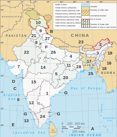
English: Numbered map of India's states, union territories, and international territorial disputes. Based on Planemad's w:File:India map en.svg and Nichalp's w:File:India-states-numbered.svg. Same references. |
| Date | |
| Source | Own work, adapted from Planemad's w:File:India map en.svg and Nichalp's w:File:India-states-numbered.svg. |
| Author | Saravask |
| SVG development |
Administrative divisions
[edit]
India consists of 29 states and 7 Union Territories. All states and territories, including the two union territories of Puducherry and the National Capital Territory of Delhi, have elected legislatures and governments patterned on the Westminster system. The other five union territories are directly ruled by the Centre through appointed administrators. In 1956, under the States Reorganisation Act, states were formed on a linguistic basis.[1] (See also: Political integration of India.) Since then, this structure has remained largely unchanged. Each state or union territory is further divided into administrative districts.[2] The districts in turn are further divided into tehsils and eventually into villages.
States:
Union Territories:
References
[edit]
- ↑ States Reorganisation Act, 1956. Constitution of India. Commonwealth Legal Information Institute. Archived from the original on 2008-05-16. Retrieved on 31 October 2007.
- ↑ Districts of India. Government of India. National Informatics Centre (NIC). Retrieved on 25 November 2007.
Licensing
[edit]
- You are free:
- to share – to copy, distribute and transmit the work
- to remix – to adapt the work
- Under the following conditions:
- attribution – You must give appropriate credit, provide a link to the license, and indicate if changes were made. You may do so in any reasonable manner, but not in any way that suggests the licensor endorses you or your use.
- share alike – If you remix, transform, or build upon the material, you must distribute your contributions under the same or compatible license as the original.
File history
Click on a date/time to view the file as it appeared at that time.
| Date/Time | Thumbnail | Dimensions | User | Comment | |
|---|---|---|---|---|---|
| current | 10:32, 22 December 2011 | | 1,594 × 1,868 (342 KB) | Saravask (talk | contribs) | Reverted to version as of 18:56, 21 December 2011 |
| 10:20, 22 December 2011 |  | 1,594 × 1,868 (309 KB) | Saravask (talk | contribs) | test | |
| 18:56, 21 December 2011 |  | 1,594 × 1,868 (342 KB) | Saravask (talk | contribs) | tweak lines | |
| 16:28, 21 December 2011 |  | 1,594 × 1,868 (330 KB) | Saravask (talk | contribs) | wrong | |
| 16:26, 21 December 2011 |  | 1,594 × 1,868 (330 KB) | Saravask (talk | contribs) | lighten (again) | |
| 15:59, 21 December 2011 |  | 1,594 × 1,868 (330 KB) | Saravask (talk | contribs) | lighten | |
| 14:44, 21 December 2011 |  | 1,594 × 1,868 (329 KB) | Saravask (talk | contribs) | tweak | |
| 14:14, 21 December 2011 |  | 1,594 × 1,868 (329 KB) | Saravask (talk | contribs) | tweak | |
| 13:42, 21 December 2011 |  | 1,594 × 1,868 (329 KB) | Saravask (talk | contribs) | tweak | |
| 13:20, 21 December 2011 |  | 1,594 × 1,868 (327 KB) | Saravask (talk | contribs) | tweak |
You cannot overwrite this file.
File usage on Commons
There are no pages that use this file.