File:Washington Metro diagram sb.svg
Jump to navigation
Jump to search

Size of this PNG preview of this SVG file: 780 × 600 pixels. Other resolutions: 312 × 240 pixels | 625 × 480 pixels | 999 × 768 pixels | 1,280 × 984 pixels | 2,560 × 1,968 pixels | 1,600 × 1,230 pixels.
Original file (Animated SVG file, nominally 1,600 × 1,230 pixels, file size: 58 KB)
Note: Due to technical limitations, thumbnails of this file will not be animated.
Captions
Captions
infographic
| Description |
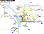
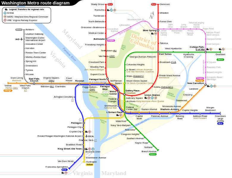
English: Route diagram of Washington Metro, including related routes under construction. (The Purple Line is not part of Washington Metro, but will connect to the Metro lines at the stations indicated.)
|
|||
| Date | 27 November 2015, 13:36:31 (upload date) | |||
| Source | Own work | |||
| Author | Sameboat | |||
| Permission (Reusing this file) |
I, the copyright holder of this work, hereby publish it under the following license: This file is licensed under the Creative Commons Attribution-Share Alike 4.0 International license.
|
|||
| Other versions |
|

This vector image was created with a text editor.
Please do not replace the simplified code of this file with a version created with Inkscape or any other vector graphics editor

|
This SVG file contains embedded text that can be translated into your language, using any capable SVG editor, text editor or the SVG Translate tool. For more information see: About translating SVG files. |

|
This image is an animated SVG file. The .png preview above created by RSVG for use in Wikimedia is not animated and may be incomplete or incorrect. To see the animation, open media:Washington Metro diagram sb.svg. It should run in any modern browser or viewer. Recent versions of Chrome, Firefox, Microsoft Edge, Safari, and Opera all support SVG animated with SMIL.
Other SVG animations can be found at Category:Animated SVG files.
|
File history
Click on a date/time to view the file as it appeared at that time.
| Date/Time | Thumbnail | Dimensions | User | Comment | |
|---|---|---|---|---|---|
| current | 13:27, 19 May 2023 | | 1,600 × 1,230 (58 KB) | Sameboat (talk | contribs) | |
| 13:27, 19 May 2023 |  | 1,600 × 1,230 (58 KB) | Sameboat (talk | contribs) | ||
| 13:25, 19 May 2023 |  | 1,600 × 1,230 (58 KB) | Sameboat (talk | contribs) | minor offset of station icons of College Park–U of Md | |
| 13:23, 19 May 2023 |  | 1,600 × 1,230 (58 KB) | Sameboat (talk | contribs) | fix yellow line and flip the Mount Vernon Square yellow station icon | |
| 12:58, 19 May 2023 |  | 1,600 × 1,230 (58 KB) | Sameboat (talk | contribs) | It's already done in the previous version. Reverted to version as of 02:20, 18 May 2023 (UTC) | |
| 08:15, 19 May 2023 |  | 1,600 × 1,230 (57 KB) | Twotwofourtysix (talk | contribs) | Update per request at Commons:Graphic Lab/Map workshop | |
| 02:20, 18 May 2023 |  | 1,600 × 1,230 (58 KB) | Sameboat (talk | contribs) | ||
| 02:16, 18 May 2023 |  | 1,600 × 1,230 (58 KB) | Sameboat (talk | contribs) | ||
| 01:50, 18 May 2023 |  | 1,600 × 1,230 (58 KB) | Sameboat (talk | contribs) | + Potomac Yard–VT station | |
| 00:11, 15 November 2022 |  | 1,600 × 1,230 (58 KB) | PlanetJuice (talk | contribs) | Add parking to Silver extension, add station name changes from 11 Sept 2022 |
You cannot overwrite this file.
File usage
The following 66 pages use this file:
- Washington Metro
- User:Chumwa/OgreBot/Potential transport maps/2016 March 11-20
- User:Chumwa/OgreBot/Potential transport maps/2016 November 11-20
- User:Chumwa/OgreBot/Potential transport maps/2017 February 19-28
- User:Chumwa/OgreBot/Potential transport maps/2017 January 1-10
- User:Chumwa/OgreBot/Potential transport maps/2017 January 11-20
- User:Chumwa/OgreBot/Potential transport maps/2017 June 21-30
- User:Chumwa/OgreBot/Potential transport maps/2017 September 1-10
- User:Chumwa/OgreBot/Potential transport maps/2018 July 11-20
- User:Chumwa/OgreBot/Potential transport maps/2018 March 1-10
- User:Chumwa/OgreBot/Potential transport maps/2020 January 1-10
- User:Chumwa/OgreBot/Public transport information/2015 December 1-10
- User:Chumwa/OgreBot/Public transport information/2015 December 11-20
- User:Chumwa/OgreBot/Public transport information/2015 November 21-30
- User:Chumwa/OgreBot/Public transport information/2016 March 11-20
- User:Chumwa/OgreBot/Public transport information/2016 March 21-31
- User:Chumwa/OgreBot/Public transport information/2016 November 11-20
- User:Chumwa/OgreBot/Public transport information/2017 February 19-28
- User:Chumwa/OgreBot/Public transport information/2017 January 1-10
- User:Chumwa/OgreBot/Public transport information/2017 January 11-20
- User:Chumwa/OgreBot/Public transport information/2017 June 21-30
- User:Chumwa/OgreBot/Public transport information/2017 September 1-10
- User:Chumwa/OgreBot/Public transport information/2018 July 11-20
- User:Chumwa/OgreBot/Public transport information/2018 March 1-10
- User:Chumwa/OgreBot/Public transport information/2020 December 21-31
- User:Chumwa/OgreBot/Public transport information/2020 January 1-10
- User:Chumwa/OgreBot/Public transport information/2022 November 11-20
- User:Chumwa/OgreBot/Public transport information/2023 May 11-20
- User:Chumwa/OgreBot/Transport Maps/2015 December 1-10
- User:Chumwa/OgreBot/Transport Maps/2015 December 11-20
- User:Chumwa/OgreBot/Transport Maps/2015 November 21-30
- User:Chumwa/OgreBot/Transport Maps/2016 March 11-20
- User:Chumwa/OgreBot/Transport Maps/2016 March 21-31
- User:Chumwa/OgreBot/Transport Maps/2016 November 11-20
- User:Chumwa/OgreBot/Transport Maps/2017 February 19-28
- User:Chumwa/OgreBot/Transport Maps/2017 January 1-10
- User:Chumwa/OgreBot/Transport Maps/2017 January 11-20
- User:Chumwa/OgreBot/Transport Maps/2017 June 21-30
- User:Chumwa/OgreBot/Transport Maps/2017 September 1-10
- User:Chumwa/OgreBot/Transport Maps/2018 July 11-20
- User:Chumwa/OgreBot/Transport Maps/2018 March 1-10
- User:Chumwa/OgreBot/Transport Maps/2020 December 21-31
- User:Chumwa/OgreBot/Transport Maps/2020 January 1-10
- User:Chumwa/OgreBot/Transport Maps/2022 November 11-20
- User:Chumwa/OgreBot/Transport Maps/2023 May 11-20
- User:Chumwa/OgreBot/Travel and communication maps/2016 March 11-20
- User:Chumwa/OgreBot/Travel and communication maps/2016 March 21-31
- User:Chumwa/OgreBot/Travel and communication maps/2016 November 11-20
- User:Chumwa/OgreBot/Travel and communication maps/2017 February 19-28
- User:Chumwa/OgreBot/Travel and communication maps/2017 January 1-10
- User:Chumwa/OgreBot/Travel and communication maps/2017 January 11-20
- User:Chumwa/OgreBot/Travel and communication maps/2017 June 21-30
- User:Chumwa/OgreBot/Travel and communication maps/2017 September 1-10
- User:Chumwa/OgreBot/Travel and communication maps/2018 July 11-20
- User:Chumwa/OgreBot/Travel and communication maps/2018 March 1-10
- User:Chumwa/OgreBot/Travel and communication maps/2020 December 21-31
- User:Chumwa/OgreBot/Travel and communication maps/2020 January 1-10
- User:Chumwa/OgreBot/Travel and communication maps/2022 November 11-20
- User:GeorgR (de)/Rail Transport in the US/2022 November
- User:GeorgR (de)/Rail Transport in the US/2023 May
- User:Sameboat
- Commons:Graphic Lab/Map workshop/Archive/2023
- File:Washington Metro diagram sb.pdf
- File:Washington Metro diagram sb.svg
- Category:Washington Metro
- Category:Washington Metro stations
Global file usage
The following other wikis use this file:
- Usage on bg.wikipedia.org
- Usage on bn.wikipedia.org
- Usage on ca.wikipedia.org
- Usage on cs.wikipedia.org
- Usage on da.wikipedia.org
- Usage on de.wikipedia.org
- Usage on de.wikivoyage.org
- Usage on en.wikipedia.org
- Usage on en.wikivoyage.org
- Usage on eo.wikipedia.org
- Usage on es.wikipedia.org
- Usage on eu.wikipedia.org
- Usage on fa.wikipedia.org
- Usage on fi.wikipedia.org
- Usage on fi.wikivoyage.org
- Usage on fr.wikipedia.org
- Métro de Washington
- Dupont Circle (métro de Washington)
- Red Line du métro de Washington
- Blue Line du métro de Washington
- Orange Line du métro de Washington
- Yellow Line du métro de Washington
- Green Line du métro de Washington
- Silver Line du métro de Washington
- Shady Grove (métro de Washington)
- Glenmont (métro de Washington)
- Metro Center (métro de Washington)
- Farragut North (métro de Washington)
- Gallery Place-Chinatown (métro de Washington)
- Judiciary Square (métro de Washington)
View more global usage of this file.