File:GlenHelenGorge NorthernTerritory Panorama.jpg

Tập tin gốc (10.609×2.340 điểm ảnh, kích thước tập tin: 17,6 MB, kiểu MIME: image/jpeg)
Chú thích
Chú thích
|

Bức hình này đã được chọn làm hình ảnh của ngày trên Wikimedia Commons vào ngày 1 tháng 7 năm 2010. Dưới đây là lời mô tả: English: Today is "Territory Day" in the Northern Territory of Australia, and marks the commencement of self-government in the Territory on 1st July 1978. This photograph is of the western wall of the Glen Helen Gorge, part of the West MacDonnell Ranges in the Northern Territory. These ranges were formed when the Alice Springs Orogeny pushed a 12km thick slab of rock vertical, running roughly east-west for 644km. Các ngôn ngữ khác:
Afrikaans: Vandag is dit "Territory Day" (d.w.s. "Territoriumdag") in die Australiese Noordelike Territorium, 'n dag wat geskiedkundig beskou word as die dag waarop die territorium selfbestuur verkry het, naamlik 1 Julie 1978. Die foto toon die westelike rand van die Glen Helen Kloof in die MacDonnellgebergte. Die gebergte bestaan uit 'n aantal ewewydig gerangskikte bergkettings in die territorium. Dit is gevorm toe die Alice Springs orogenese ('n bergvorming vernoem na die gelyknamige dorp) oor 'n lengte van 644km 'n laag rots van 12km dikte, rofweg van oos na wes, vertikaal omhoog gedruk het. Čeština: Západní stěna Glen Helen Gorge, části pohoří MacDonnell Ranges v australském Severním teritoriu; dnes se v Severním teritoriu slaví výročí získání autonomie 1. července 1978 Dansk: I dag er det "Territory Day" i Northern Territory i Australien til minde om indførelsen af selvstyre for territoriet 1. juli 1978. Dette foto viser vestsiden af Glen Helen Gorge, der er en del af MacDonnell Ranges i Northern Territory. Deutsch: Heute ist "Territory Day" in den australischen Northern Territory. Das Datum markiert den Beginn der Selbstverwaltung dieses Territoriums am 1. Juli 1978. Dieses Foto zeigt die Westwand der Glen Helen Gorge, ein Teil der West MacDonnell Ranges. Diese Gebirgszüge wurden gebildet, als sich während der Orogenese von Alice Springs eine 12km dicke Felsplatte vertikal verschob. Sie verläuft etwa 644km in Ost/West-Richtung. English: Today is "Territory Day" in the Northern Territory of Australia, and marks the commencement of self-government in the Territory on 1st July 1978. This photograph is of the western wall of the Glen Helen Gorge, part of the West MacDonnell Ranges in the Northern Territory. These ranges were formed when the Alice Springs Orogeny pushed a 12km thick slab of rock vertical, running roughly east-west for 644km. Español: La pared occidental del Glen Helen Gorge, en la cadena montañosa de 640 km de longitud del West MacDonnell Ranges en el Territorio del Norte, Australia. Esta fracturada montaña se formó durante la orogenésis de Alice Springs, un evento tectónico ocurrido hace entre 450 y 300 millones de años en Australia Central. Hoy es el Territory Day (‘día del territorio’) en el Territorio del Norte, el aniversario de la institución del gobierno federal (1 de julio de 1978). Italiano: La parete occidentale del Glen Helen Gorge, nella catena montuosa (640 km di lunghezza) dei West MacDonnell Ranges nel Territorio del Nord, in Australia. Queste frastagliate montagne si sono formate durante l'orogenesi di Alice Springs, un evento tettonico intercorso tra i 450 e i 300 Ma fa nell'Australia Centrale. Oggi è il “Territory Day” («giorno del territorio») nel Territorio del Nord, l'anniversario dell'istituzione del governo federale (1º luglio 1978). Magyar: A mai nap az ausztráliai Northern Territoryban a Territory Day ünnepe, a Territory önkormányzatának 1978. július 1-jei születésére emlékezik. A fotón a Glen Helen Gorge nyugati fala látható Nederlands: Vandaag is het "Territory Day" ("Territoriumdag") in het Australische Noordelijk Territorium, historisch gezien de dag waarop het territorium zelfbestuur verkreeg op 1 juli 1978. De foto toont de westelijke rand van de Glen Helen Gorge, een kloof in het MacDonnellgebergte. Dit gebergte bestaat uit een aantal evenwijdig aan elkaar gelegen bergketens in het territorium die werden gevormd toen de Orogenese van Alice Springs (naar het gelijknamige stadje) over een lengte van 644 kilometer een 12 kilometer dikke laag rots verticaal omhoog drukte, grofweg in oost-westelijke richting. Norsk bokmål: I dag er det «Territory Day» i Nordterritoriet i Australia til minne om innførselen av selvstyre for territoriet 1. juli 1978. Dette bildet viser vestsiden av Glen Helen Gorge, som er en del av MacDonnell Ranges i Nordterritoriet. Македонски: Западниот бедем на клисурата Глен Хелен на планинскиот венец Вест Макдонел во Северната Територија, Австралија. বাংলা : আজ অস্ট্রেলিয়ার নর্দার্ন টেরিটতে আজকে ‘টেরিটরি দিবস’। এই দিনে এখানে ১৯৭৮ সালের ১ জুলাই পাওয়া স্বায়ত্বশাসন উদযাপন করা হয়। এই আলোকচিত্রে গ্লেন হেলেন জর্জের পশ্চিম দিকের দেওয়ালটি ফুটিয়ে তোলা হয়েছে। এটি নর্দার্ন টেরিটরির পশ্চিম ম্যাকডানেল রেঞ্জের অংশ। 日本語: 今日7月1日はノーザンテリトリー(オーストラリア)の「テリトリー・デー」。ノーザンテリトリーは準州として1978年7月1日に自治権を獲得した。写真は同テリトリーに位置する西マクドネル山脈の一部をなすグレン・ヘレン峡谷の西壁。マクドネル山脈はアリススプリングス造山運動の際、概ね東西方向644kmにわたる厚さ12kmの岩盤が押されることで形成されたものである。 中文: 澳大利亚北领地麦克唐奈尔山脉格兰海伦峡谷风景。这些山脉因艾丽丝泉造山运动形成12公里厚的垂直岩石板,延绵644公里。 中文(繁體): 澳洲北領地麥克唐奈爾山脈格蘭海倫峽谷風景。這些山脈因艾麗絲泉造山運動形成12公里厚的垂直岩石板,延綿644公里。 |
Miêu tả[sửa]
| Miêu tả |
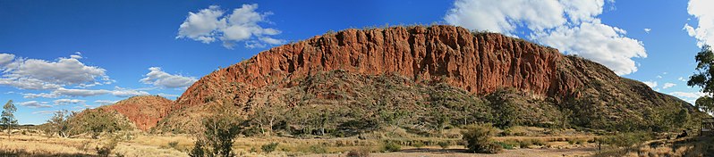
English: A panoramic view of the western wall of the Glen Helen Gorge in the late afternoon. The Gorge itself can be seen in between peaks on the left. The Finke river, with its mostly dry river bed and glimpses of water, can be seen in the foreground. The trees along the river bed are primarily River Red Gums. The cloud cover is the start of an infrequent dry season cold front which brought rains to the region.
This geological formation is part of the West MacDonnell Ranges in Australia's Northern Territory. The layers once lay horizontal at the bottom of the Amadeus basin. The Alice Springs orogeny pushed a 12km thick slab vertical, running roughly east-west for 644km. This gorge is primarily formed of red quartzite, which withstood subsequent erosion better than the softer layers around it. The entire Ranges have been classified as National Park. Français : Vue panoramique du bord ouest de la gorge Glen Helen en fin d'après-midi. La gorge elle même est visible entre les sommets sur la gauche de l'image. Le lit de la rivière Finke, avec un peu d'eau, est au premier plan. Les arbres qui la bordent sont principalement des Gommiers rouges. Les nuages annoncent un front froid porteur de pluie, un évènement peu fréquent durant la saison sèche. Cette formation géologique fait partie de la chaine des West MacDonnell dans le Territoire du Nord australien. L'orogénie d'Alice Springs a redressé une dalle de 12 km de quartzites rouges sur une longueur de 644 km. La gorge a été creusée dans cette dalle, qui a mieux supporté l'érosion que les roches plus tendres qui l'entouraient au moment de l'orogénie. La chaine est totalement incluse dans un parc national. |
| Ngày | |
| Nguồn gốc | Tác phẩm được tạo bởi người tải lên |
| Tác giả | Toby Hudson |
| Phiên bản khác |
 |
_WV_banner.jpg)
| Vị trí máy chụp hình | | Xem hình này và các hình ảnh lân cận trên: OpenStreetMap |
|---|
Giấy phép[sửa]
- Bạn được phép:
- chia sẻ – sao chép, phân phối và chuyển giao tác phẩm
- pha trộn – để chuyển thể tác phẩm
- Theo các điều kiện sau:
- ghi công – Bạn phải ghi lại tác giả và nguồn, liên kết đến giấy phép, và các thay đổi đã được thực hiện, nếu có. Bạn có thể làm các điều trên bằng bất kỳ cách hợp lý nào, miễn sao không ám chỉ rằng người cho giấy phép ủng hộ bạn hay việc sử dụng của bạn.
- chia sẻ tương tự – Nếu bạn biến tấu, biến đổi, hoặc làm tác phẩm khác dựa trên tác phẩm này, bạn chỉ được phép phân phối tác phẩm mới theo giấy phép y hệt hoặc tương thích với tác phẩm gốc.

|
Bạn có quyền sao chép, phân phối và/hoặc sửa đổi tài liệu này theo những điều khoản được quy định trong Giấy phép Tài liệu Tự do GNU, phiên bản 1.2 hoặc các phiên bản mới hơn được Quỹ Phần mềm Tự do; quy định; ngoại trừ những phần không được sửa đổi, bìa trước và bìa sau. Bạn có thể xem giấy phép nói trên ở phần Giấy phép Tài liệu Tự do GNU. |
| Annotations | This image is annotated: View the annotations at Commons |
Lịch sử tập tin
Nhấn vào ngày/giờ để xem nội dung tập tin tại thời điểm đó.
| Ngày/Giờ | Hình xem trước | Kích cỡ | Thành viên | Miêu tả | |
|---|---|---|---|---|---|
| hiện tại | 21:24, ngày 29 tháng 10 năm 2009 | 10.609×2.340 (17,6 MB) | Sting (thảo luận | đóng góp) | Same image but with sRGB color profile embedded | |
| 14:04, ngày 23 tháng 10 năm 2009 | 10.609×2.340 (17,29 MB) | 99of9 (thảo luận | đóng góp) | Resaved with EXIF data embedded and cloned dark regions of upper left sky (per User:Sting, thanks again!) | ||
| 07:00, ngày 23 tháng 10 năm 2009 | 10.609×2.340 (17,37 MB) | 99of9 (thảo luận | đóng góp) | {{Information |Description={{en|1=A panoramic view of the western wall of the Glen Helen Gorge in the late afternoon. The Gorge itself can be seen in between peaks on the left. The Finke river, with its mostly dry river bed, and glimpses of water can be |
Bạn không được phép ghi đè tập tin này.
Trang sử dụng tập tin
73 trang sau sử dụng tập tin này:
- Talk:Main Page/Archive 3
- User:99of9/Gallery
- User:99of9/Profile
- User:S23678/Downsampling2
- User talk:99of9/Promotions
- Commons:Conhece os nossos fotógrafos
- Commons:Conoce a nuestros fotógrafos
- Commons:Descobrètz nòstres fotografes
- Commons:Découvrez nos photographes
- Commons:Featured picture candidates/File:GlenHelenGorge NorthernTerritory Panorama.jpg
- Commons:Featured picture candidates/Log/November 2009
- Commons:Featured pictures/Places/Natural/Australia
- Commons:Featured pictures/Places/Panoramas
- Commons:Featured pictures/chronological/2009-B
- Commons:Fotoğrafçılarımızla tanışın
- Commons:Meet our photographers
- Commons:Meet our photographers/People
- Commons:Picture of the Year/2009/Galleries/2009-B
- Commons:Picture of the Year/2009/Galleries/All
- Commons:Picture of the Year/2009/Galleries/Index/16
- Commons:Picture of the Year/2009/Galleries/Index/Panoramas
- Commons:Picture of the Year/2009/Galleries/Panoramas
- Commons:Picture of the Year/2009/Galleries/Panoramas/1
- Commons:Picture of the Year/2009/Galleries/Table/200911
- Commons:Picture of the Year/2009/R1/File:GlenHelenGorge NorthernTerritory Panorama.jpg
- Commons:Picture of the Year/2009/Results/R1/ALL/Table
- Commons:Picture of the Year/2009/Results/R1/Panoramas
- Commons:Picture of the Year/2009/Results/R1/Panoramas/Table
- Commons:Potd/2010-07 (da)
- Commons:Potd/2010-07 (de)
- Commons:Potd/2010-07 (nl)
- Commons:Potd/2010-07 (pt)
- Commons:Poznaj naszych fotografów
- Commons:Scopri i nostri fotografi
- Commons:Scummigghia ê nostri fotògrafi
- Commons:Temui jurugambar kami
- Commons:Unsere Fotografen stellen sich vor
- Commons:Unseri Fotografe stelle sich vor
- Commons:Upoznajte naše fotografe
- Commons:Биздин фотографтар менен таанышыңыз
- Commons:Запознајте ги нашите фотографи
- Commons:Знакомьтесь с нашими фотографами
- Commons:قابل مصورينا
- Commons:私達の写真家をご紹介します
- Commons:结识我们的摄影师
- Commons:结识我们的摄影师/人们
- Commons:우리들의 사진가를 만나보세요
- File:GlenHelenGorge NorthernTerritory Australia.JPG
- File:Red Centre Itinerary (GlenHelenGorge) WV banner.jpg
- Template:Potd/2010-07
- Template:Potd/2010-07-01
- Template:Potd/2010-07-01 (af)
- Template:Potd/2010-07-01 (bn)
- Template:Potd/2010-07-01 (cs)
- Template:Potd/2010-07-01 (da)
- Template:Potd/2010-07-01 (de)
- Template:Potd/2010-07-01 (en)
- Template:Potd/2010-07-01 (es)
- Template:Potd/2010-07-01 (hu)
- Template:Potd/2010-07-01 (it)
- Template:Potd/2010-07-01 (ja)
- Template:Potd/2010-07-01 (ko)
- Template:Potd/2010-07-01 (mk)
- Template:Potd/2010-07-01 (nb)
- Template:Potd/2010-07-01 (nl)
- Template:Potd/2010-07-01 (pt)
- Template:Potd/2010-07-01 (ru)
- Template:Potd/2010-07-01 (sv)
- Template:Potd/2010-07-01 (zh-hans)
- Template:Potd/2010-07-01 (zh-hant)
- Template:Potd/2010-07/short
- Template:Potd/2010-07 (zh-hans)
- Category:MacDonnell Ranges
Sử dụng tập tin toàn cục
Những wiki sau đang sử dụng tập tin này:
- Trang sử dụng tại bn.wikipedia.org
- Trang sử dụng tại ca.wikipedia.org
- Trang sử dụng tại ceb.wikipedia.org
- Trang sử dụng tại crh.wikipedia.org
- Trang sử dụng tại cv.wikipedia.org
- Trang sử dụng tại en.wikipedia.org
- Trang sử dụng tại en.wikivoyage.org
- Trang sử dụng tại es.wikipedia.org
- Trang sử dụng tại eu.wikipedia.org
- Trang sử dụng tại hu.wikipedia.org
- Trang sử dụng tại it.wikivoyage.org
- Trang sử dụng tại ko.wikipedia.org
- Trang sử dụng tại krc.wikipedia.org
- Trang sử dụng tại lbe.wikipedia.org
- Trang sử dụng tại mg.wikipedia.org
- Trang sử dụng tại mk.wikipedia.org
- Trang sử dụng tại ml.wikipedia.org
- Trang sử dụng tại os.wikipedia.org
- Trang sử dụng tại pl.wikipedia.org
- Trang sử dụng tại pt.wikipedia.org
- Trang sử dụng tại ru.wikipedia.org
- Trang sử dụng tại ru.wikinews.org
- Trang sử dụng tại sah.wikipedia.org
- Trang sử dụng tại uk.wikipedia.org
- Trang sử dụng tại vi.wikipedia.org
- Trang sử dụng tại www.wikidata.org
- Trang sử dụng tại xal.wikipedia.org
- Trang sử dụng tại zh.wikipedia.org