File:Warning sign in cologne.jpg

Original file (2,119 × 1,649 pixels, file size: 920 KB, MIME type: image/jpeg)
Captions
Captions
|

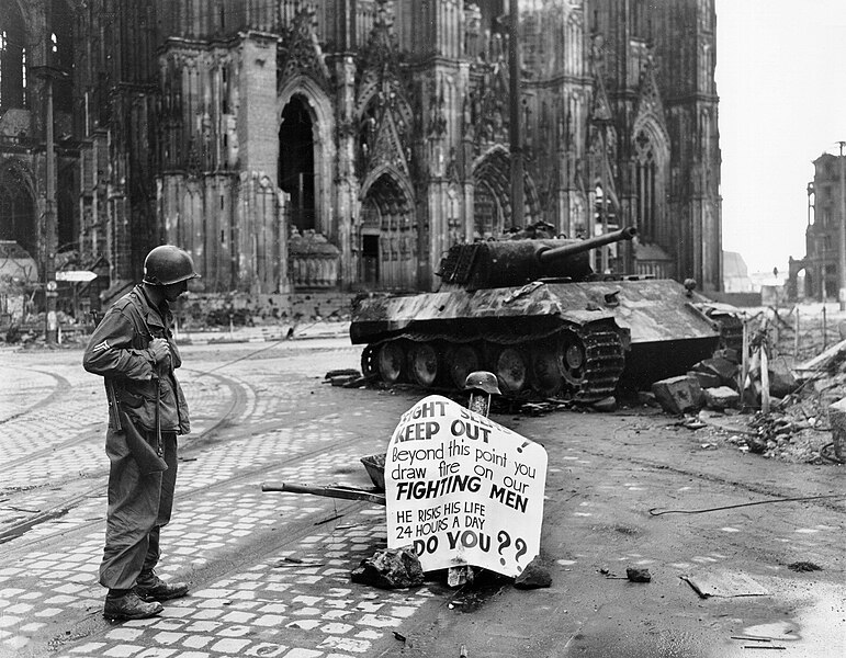
This image was selected as picture of the day on Wikimedia Commons for 30 May 2006. It was captioned as follows: English: A Cpl. of 82nd Airborne Division reads a warning sign in the street Cologne, Germany, 4 April 1945. Other languages:
Bahasa Melayu: Seorang Korporal dari 82nd Airborne Division membaca sebuah tanda amaran di jalan Cologne, Jerman, 4 April 1945. Català: Un soldat americá mira un cartell davant la catedral de Colonia Čeština: Voják čtoucí varování, Kolín nad Rýnem, Německo, 4. dubna 1945 Cymraeg: Milwr Americanaidd yn darllen arwydd o rybudd o yng Nghwlen (Cologne), yr Almaen, 4ydd o Ebrill 1945. Dansk: En amerikansk korporal i 82nd Airborne Division læsende et advarselsskilt i Köln, 4. april 1945. Deutsch: Ein Korporal der 82nd Airborne Division der U.S. Armee liest ein Warnschild auf der Straße; Köln, Deutschland, 4. April 1945. English: A Cpl. of 82nd Airborne Division reads a warning sign in the street Cologne, Germany, 4 April 1945. Español: Un soldado americano lee un cartel ante la catedral de Colonia Français : Un caporal de la U.S. 82nd Airborne Division (82e division aéroportée américaine) lisant un avertissement dans une rue de Cologne, Allemagne, le 4 avril 1945 Galego: Un cabo da 82 División Aerotransportada le un aviso nunha rúa de Colonia, Alemaña, 4 de abril de 1945. Lëtzebuergesch: E Kaperol vun der 82nd Airborne Division vun der U.S. Arméi liest e Warnschëld op enger Strooss zu Köln, Däitschland, 4. Abrëll 1945. Polski: Kapral 82 dywizji powietrzno-desantowej czyta napis ostrzegawczy na ulicy Kolonii. Niemcy, 4 kwietnia 1945. Português: Um soldado americano lendo um cartaz diante da catedral de Colônia, Alemanha em 4 de abril de 1945. Suomi: Alikersantti 82. maahanlaskudivisioonasta, tunnettu myös nimellä "All-Americas", lukee varoituskylttiä Kölnissä, Saksassa, 4. huhtikuuta 1945 Svenska: En amerikansk soldat läser en varningsskylt på en gata i Köln den 4 april 1945. العربية : كولن، ألمانيا، 4 أبريل 1945. |
This image was selected as picture of the day on Vietnamese Wikipedia.
|
Summary[edit]
| Description |
English: Original caption: Cologne, Germany - Cpl. Luther E. Boger, Concord, N.C., skytrooper, reads a warning sign in the street. This street leads to the Rhine River and is under observation of the Germans who occupy a stronghold there. Cpl. Boger is with the 82nd Airborne Division. 4 April 1945. The German tank is burnt out and the torsion-bars have been destroyed by the immense heat of the fire.
|
| Date | Taken on 4 April 1945 |
| Source | US-Army history images (jpeg) |
| Author | Post processing by User:W.wolny |
| Other versions |
.jpg)
| Camera location | | View this and other nearby images on: OpenStreetMap |
|---|
Licensing[edit]
This file is a work of a U.S. Army soldier or employee, taken or made as part of that person's official duties. As a work of the U.S. federal government, it is in the public domain in the United States.
|
 |
File history
Click on a date/time to view the file as it appeared at that time.
| Date/Time | Thumbnail | Dimensions | User | Comment | |
|---|---|---|---|---|---|
| current | 11:16, 20 April 2005 | | 2,119 × 1,649 (920 KB) | W.wolny (talk | contribs) |
You cannot overwrite this file.
File usage on Commons
The following 42 pages use this file:
- 82nd Airborne Division
- Cologne
- Kölner Dom
- Panzerkampfwagen V
- User:Dschwen/FP2006
- User:KennethJorgensen/Favorites
- User:Thgoiter/Favourites
- Commons:Featured picture candidates/Image:Warning sign in cologne.jpg
- Commons:Featured picture candidates/Log/March 2006
- Commons:Featured pictures/Historical
- Commons:Featured pictures/chronological/2006-A
- Commons:Picture of the Year/2006/gallery
- Commons:Picture of the Year/2006/gallery0
- Commons:Picture of the Year/2006/gallery large
- Commons:Potd/2006-05 (fr)
- Commons:Potd/2006-05 (pl)
- Commons:Potd/2006-05 (pt)
- Commons:Potd/2006-05 (tr)
- Commons talk:Featured picture candidates/Archive candidate list
- File:Warning sign in cologne (cropped).jpg
- Template:Potd/2006-05
- Template:Potd/2006-05-30
- Template:Potd/2006-05-30 (ar)
- Template:Potd/2006-05-30 (ca)
- Template:Potd/2006-05-30 (cs)
- Template:Potd/2006-05-30 (cy)
- Template:Potd/2006-05-30 (da)
- Template:Potd/2006-05-30 (de)
- Template:Potd/2006-05-30 (en)
- Template:Potd/2006-05-30 (es)
- Template:Potd/2006-05-30 (fi)
- Template:Potd/2006-05-30 (fr)
- Template:Potd/2006-05-30 (gl)
- Template:Potd/2006-05-30 (ja)
- Template:Potd/2006-05-30 (lb)
- Template:Potd/2006-05-30 (ms)
- Template:Potd/2006-05-30 (pl)
- Template:Potd/2006-05-30 (pt)
- Template:Potd/2006-05-30 (ru)
- Template:Potd/2006-05-30 (sv)
- Template:Potd/2006-05-30 (zh-hans)
- Template:Potd/2006-05-30 (zh-hant)
File usage on other wikis
The following other wikis use this file:
- Usage on ar.wikipedia.org
- Usage on az.wikipedia.org
- Usage on bg.wikipedia.org
- Usage on ca.wikipedia.org
- Usage on cs.wikipedia.org
- Usage on da.wikipedia.org
- Usage on de.wikipedia.org
- Usage on de.wiktionary.org
- Usage on el.wikipedia.org
- Usage on en.wikipedia.org
- Usage on es.wikipedia.org
- Usage on eu.wikipedia.org
- Usage on fi.wikipedia.org
- Usage on fr.wikipedia.org
- Usage on fy.wikipedia.org
- Usage on he.wikipedia.org
- Usage on hu.wikipedia.org
- Usage on hy.wikipedia.org
- Usage on hyw.wikipedia.org
- Usage on ia.wikipedia.org
- Usage on id.wikipedia.org
- Usage on is.wikipedia.org
View more global usage of this file.
- Panzerkampfwagen V Ausführung A during World War II
- Warning signs in North Rhine-Westphalia
- Signs in Cologne
- 1945 in Cologne
- Historical images of Cologne
- 82nd Airborne Division
- Destroyed tanks
- Soldiers of the United States
- Thompson M1
- Black and white photographs of Cologne
- Black and white photographs of Germany in 1945
- Black and white photographs of men wearing military uniforms
- Black and white photographs of tanks in Germany
- Black and white photographs of World War II
- Boger (surname)
- Cologne Cathedral in World War II
- English-language signs in Germany
- Kölner Domplombe (Cologne Cathedral)
- Luther (given name)
- Male humans with helmets
- Men facing right and looking right
- Men of North Carolina
- Military men wearing boots
- Military people of North Carolina
- Military people of the United States in 1945
- Military people standing
- People of Concord, North Carolina
- People with signs in Germany
- Standing men in Germany
- 20th-century men of the United States