File talk:Syrian civil war.png
Violet points[edit]
What are violet points and areas (for example in Damascus)? It isn`t explain in description — Preceding unsigned comment was added by 46.112.89.28 (talk) 08:33, 30 December 2015 (UTC)
- Truces. Banak (talk) 15:42, 31 December 2015 (UTC)
Al-Qusayr[edit]
Al-Qusayr is under SAA possesion. Tal-callah too. — Preceding unsigned comment was added by 77.71.116.61 (talk) 09:24, July 30, 2013 (UTC)
Alkosair and tallkalakh[edit]
Please note :
- Alkosair and tallkalakh controlled 100% by the government forces
- The rebels didn't reach the sea
- The Kurds controlled about 90% of alhasaka district — Preceding unsigned comment added by 64.121.83.138 (talk) 05:36, 1 August 2013 (UTC)
Damascus[edit]
Where is Damascus??? It's not on the map. --2001:620:40B:1112:20C0:C288:27A1:ED84 08:15, 4 November 2013 (UTC)
Update[edit]
No changes have been made in a couple of months.--Kintetsubuffalo (talk) 07:16, 25 January 2014 (UTC)
Attempt to present Israel as "involved" in the war[edit]
I must remind everyone that there is a broad consensus that neither Turkey, Israel, Jordan, Iraq or Lebanon are to be presented as "involved" on the map, no matter the political opinion of the editor. There is a broad consensus to this opinion at [1].Greyshark09 (talk) 16:44, 30 April 2014 (UTC)
SVG and basis map[edit]
I would like to ask if anyone can create SVG file (it is about time), and i would recommend using the Syria_location_map3.svg as the basis per [2].Greyshark09 (talk) 17:00, 30 April 2014 (UTC)
Tell Brak blue occupied.[edit]
There is no key for the blue colour that is occupying the northeastern town of Tell Brak, what is occupying it and why is there no key for it? — Preceding unsigned comment was added by 46.129.66.73 (talk) 21:37, June 22, 2014 (UTC)
- User:Spesh531 will have to answer that question. Magog the Ogre (talk) (contribs) 00:51, 23 June 2014 (UTC)
- Not exactly sure. It was a blue dot for the template, so I made a blue color on the map.—SPESH531Other 03:18, 23 June 2014 (UTC)
Editing the map in 20 steps[edit]
please can someone tell me how to edit this map. Alhanuty (talk) 15:03, 2 July 2014 (UTC)
- Yeah I can explain (I've been busy lately, sorry about that). Ok, this is kind of a long process to do. I guess I can list it.
- Immediately, I open an incognito page on Google Chrome or inPrivate browsing on Internet Explorer. I paste the link of the template, so none of the links are purple, to keep consistency.
- Step 1: Have paint.NET downloaded.
- Step 2: Add a new layer to the image. (IMPORTANT: You must have both "Layer 2" and "Background" on)
- Step 3: Have "Layer 2" selected and click F4 (or the little pencil on the tag symbol).
- Step 4: Set the mode to "Difference".
- Step 5: Screenshot the template page for the map.
- Step 6: Paste it onto the paint.NET program and try to match up the boundaries, so they appear black.
- Step 7: Do this until all of (in this case, Syria) is filled up. (LOOK AT THE IMAGE TO THE RIGHT)


- Step 8: Now it gets a little tricky. Read the description of second map for this step.
- Step 9: You use the "Rectangle Select" tool, an next to the tool drop-down menu, click the image that has two shaded squares. Select all areas that are basically off-color. (When the insert map of the template is changed, just copy the map, it makes life SOO much easier.)
- Step 10: Copy any areas you selected and paste them in layer "Background".
- Step 11: Deselect "Layer 2"
- Step 12-14: Select the "Magic Wand" in the toolbox. Go to where it says "Flood Mode" and change it to "Global". Change the Tolerance to 15-20% (I prefer 20%).
- Step 15: Change the double square fill in to the fourth one (two squares intersecting, so only the middle square is highlighted)
- Step 16: In areas that are white, click with the "Magic Wand" so only white areas appear.
- Step 17: Shade in the rest of the map that is now white. (WARNING: The little white areas in the top left of Kurdish circles get selected, make sure you do not shade the!)
- Step 18: After a few shade-ins, go to the "Magic Wand" and the middle square in the tool box (this is the "Subtraction", so only the top left portion of the first square is shaded) and deselect the gray ISIS, yellow Kurd, green anti-Assad, or red Government areas.
- Step 19: After doing this see if there is anything else selected, before you click "enter" (which deselects the area you have selected)
- Step 20: Delete "Layer 2", and save (make sure it is a .png)
- So that is how I edit this map, every single time. I am currently doing the next update, as there is A LOT to change, so good luck with this. I do the same for the Iraq map.—SPESH531Other 19:47, 2 July 2014 (UTC)
Deir Ez Zor routes are not cut by ISIS[edit]
On Google Earth are visible some alternative routes I draw it here - I also Draw http://sia1.subirimagenes.net/img/2014/05/12/140512015844448306.jpg
Here I draw in red my recommendation. http://sia1.subirimagenes.net/img/2014/05/12/140512015857218942.jpg
Pro Insurgent source admit the supplies to Deir Ez Zor are no cut by ISIS https://twitter.com/CdricLabrousse/status/456247355818672128 — Preceding unsigned comment added by LogFTW (talk • contribs) 00:38, 12 May 2014 (UTC)
- This map signifies Civilian Centers and Useful Land that has Presence and Control not just vast desert that has been crossed once to resemble control
- http://s1070.photobucket.com/user/amaraen1/media/SyriaMay17WithRelevence.png.html
- Also Al-Hasakah Province (North East) is pink because all the local defense units are supplied by the SAA, and the citizens will be voting on June 3rd.
- Local defense units are all over Syria working with the government it just happened to be that the people of Al-Hasakah are mostly Kurdish — Preceding unsigned comment added by 76.127.127.203 (talk) 00:11, 18 May 2014 (UTC)
Rebel offensive in south[edit]
80% of towns and ivllages are under rebel in control in the province bordering the golan heights zone.--Arbutus the tree (talk) 18:20, 15 September 2014 (UTC)
Disputed areas and Golan Heights[edit]
Considering recent edit-warring by user:SupremeDeliciousness over the implementation of the brown color for disputed areas (including Deir ez-Zor, Aleppo and Golan), i would like to point it to the source of this coloring at relevant discussion on English wikipedia, based on coloring issue of Golan Heights in Israel map and in Syrian Arab Republic maps (see [3],[4]). Supreme created another map with white color for the Golan named File:Syrian civil war 2.png, and hence i encourage him to label the white color there in a fashion he desires. (occupied, invaded, settled, or liberated - whatever). This map however should stay with brown color for disputed areas.Greyshark09 (talk) 20:58, 2 November 2014 (UTC)
Dara'a frontier[edit]
https://twitter.com/IvanSidorenko1/status/533097089711222784?lang=en
Rebel group made a map: note the border with Jordan, the eastern half is gov-controlled per pro-opp source. ChrissCh94 (talk) 15:08, 14 November 2014 (UTC)
Should I use this as an update?[edit]
I constructed this map: File:Isil in syria.png from the source from scratch as my first upload. It doesn't look as good, though is higher resolution and uses more recent information. It also contains a new colour for the al-Nusra Front Should I use it as an update?
No, that map is totaly unusable. Some points:
- The area of rebels in Eastern Qalamoun is larger and runs southwest towards Dumayr (local truce) and
- Where are the rebel held cities north of Homs? Rastan, Talbisah, Houla? There's no green there for some murky reason...
- IS connects its towns in eastern Hama with Raqqah through the desert, that way they bring in supplies to attack Shaer gas field
- Why is there red near Saraqib in Idlib?! The regime has not had a foothold there since 2012. All that area is JN or FSA held.
- Were are the rebel pockets in Qalamoun near Assal al-Ward and the Lebanese border?
- In southern Syria: rebels connect Lajat with Busra al-Harir through a small corridor running northwards. You are showing Lajat as being besieged, which it is clearly not
- Deir Abbas in Daraa: the area around the town is rebel held, since clashes are taking place at Tell Areed way north of the city. On your map it's almost cut off
- In Qamishli the SAA area stretches to far to the east. Kurds control some parts of Qamishli itself, and the deviding line is just east of the city, not miles ahead
So a good try, but not good enough.
Ok, I believe I fixed all, working on making minor changes for appearance. In the meantime, updating using latest from https://upload.wikimedia.org/wikipedia/commons/6/61/Syria_and_Iraq_2014-onward_War_map.png
Again, several points in southern Syria:
- Nasib crossing in Daraa is besieged, so the area east of it should be green towards the green dot at the Jordanian border
- The map notes Dilli as besieged by rebels, but the green does not touch the city like it does in other areas. Why?
- Same goes for Kafr Shams and the town south of it
- Same goes for the Himrit and Dayr Makir area
- Why is the Lajat area in northeastern Daraa shrunken, when the regime has not advanced there?
- Rebels control more land at the Israeli border: only near Hader is their SAA at the border
RfC on english Wikipedia[edit]
RfC: File:Syria and Iraq_2014-onward War map.png not used to highlight Israel
To be discussed on that talk page.—SPESH531Other 20:58, 17 December 2014 (UTC)
Menagh Air Base in gray[edit]
When the Islamic State took over the Menagh Military Airbase? Here in gray
Please see:
The FSA is removed from the base: Al-Monitor. Jabhat al-Nusra eyes Idlib for Islamic emirate
The ISIL is removed from the base, which is under the control of al-Nusra Front: html McClatchy DC. In Syria, ISIS pulls out of Azaz as intra-rebel battle brews. BY MITCHELL Prothero. McClatchy Foreign Staff, February 28, 2014
No meeting news that the ISIS retake the base. Greetings.--Nerêo (talk) 18:25, 28 December 2014 (UTC)
Sorry, I haven't been updating this map with the Syria and Iraq map, due to a slight problem. I notice and fixed it on the joint map. I'd imagine it came from a mistake thinking that the grey on the detailed map was black, which is why people are discussing a colour change on the detailed map.
I'll see if I can find an easy way to update this map with the combined map without too much additional effort to avoid inaccuracies building up with time. --John Smith the Gamer (talk) 01:12, 29 December 2014 (UTC)
What are these four by four dots all over the map?[edit]
No explanation given? I don't understand what they are
- Military bases? I'm not sure either Givethemahug (talk) 11:08, 19 February 2015 (UTC)
- Rural presence, ie not in a town, but surrounding area controlled by this force. Banak (talk) 15:20, 1 March 2015 (UTC)
Kurds have captured Tall Hamis[edit]
http://www.huffingtonpost.com/2015/02/27/kurds-capture-tel-hamees_n_6771684.html
https://twitter.com/Rojekazad/status/571242442017673216 71.245.70.197
http://www.srf.ch/news/international/rueckschlag-fuer-is --37.24.144.58 04:14, 28 February 2015 (UTC)
- This map is made from screenshots from the map generated by this code on English wikipedia. Unless the colouring doesn't match the dots, you should deal with changes there, subject to "the rules of editing". Alternatively mention it on its talk-page. Banak (talk) 15:26, 1 March 2015 (UTC)
Sources[edit]
Could the main athors of the map please tell us the sources for their updates? Without sources in the worst case this map could be propaganda. --Zulu55 (talk) 08:35, 9 April 2015 (UTC)
- The previous thread explains this is made from a module on Wikipedia. There are frequently plenty of sources used at the source module between every pair of updates. I do not think they would all fit in the edit summary. Regardless, I've added it to the map description. Banak (talk) 14:29, 10 April 2015 (UTC)
Where is there a key to describe the symbols such as the rows of dots that form a square? Is this an army base?
- That is "rural presence". A full key and pretty much all information can be found on en:Module:Syrian_and_Iraqi_insurgency_detailed_map/doc. Banak (talk) 12:49, 27 April 2015 (UTC)
Tel Abyad[edit]
The Tell Abyad District and the northern part of Raqqa Governorate were captured by joint forces of the FSA (sevral groups) and YPG according to all sources. Please update map accordingly. Cheers. Amr ibnu Kulthoum عمرو بن كلثوم (talk) 18:42, 25 June 2015 (UTC)
No updates in almost 10 days.[edit]
Can we get an update please?
- Sarrin is captured by PYD...
Umm Housh[edit]
I've seen on Arabic and English media that ISIS has seized Umm Housh. Is this reflected on the map? (Tip: search "ام حوش")
Notable?[edit]
I think it would be interesting if we showed the proposed "IS-free zone". link 50.187.216.93
Update[edit]
The SAA has retreated from much of al-Ghab plain. 50.187.216.93 http://www.reuters.com/article/2015/08/11/us-mideast-crisis-syria-army-idUSKCN0QG1TM20150811 I'm looking for a map
Regime Gains[edit]
Regime gains are being reported. 50.187.216.93 03:43, 19 August 2015 (UTC) They've retaken several villages in Al-Ghab that were recently captured by the rebels. This includes Mansura, Naqus, Ziyara, and Tal Waset. link 50.187.216.93 03:46, 19 August 2015 (UTC) This is reflected on "cities and towns in the syrian civil war" but not in the png. 50.187.216.93 03:57, 19 August 2015 (UTC) Oh that's odd, the map is correct but only because no one changed it to include the rebel gains in the first place. Funny how that worked out. 50.187.216.93 03:59, 19 August 2015 (UTC)
US/Turk 'save zone'[edit]
Maybe, this is usable as a source for the drawing of this zone? http://www.conflict-news.com/the-turkish-safe-zone-operation-has-begun/
I want to suggest a svg-version of this map with all versions as layers, to show an animated version of the development over the time. --82.145.221.201 21:53, 22 August 2015 (UTC)
Discrepancy[edit]
Why is there a discrepancy between this png and this one? Is al-Hawl surrounded by the YPG/YPJ or not? Monochrome Monitor (talk) 13:08, 3 September 2015 (UTC)
- Monochrome Monitor, the discrepancies can come in three ways:
- The map has not been updated since a change on the module.
- The map has accidental differences from the module (normally due to missing an area that changed)
- The map was updated with deliberate differences to the module.
- I don't believe DuckZz does the last one, so I imagine it's either an accident or as the module was on 27 August 2015, when the map was last updated. Banak (talk) 19:27, 3 September 2015 (UTC)
No Updates?[edit]
19 days passed...
convert all Versions to SVG and build a animated (Timeline) Image from all Versions?[edit]
can each editor please convert his versions to svg and upload them here? then one image can show the whole process, not only the last status. --2A02:8109:9A40:1778:34DD:6E59:AD00:22D1 12:37, 13 October 2015 (UTC)
_Image_from_all_Versi)
- This indeed would be a great thing to have! --Waschl87 (talk) 16:59, 27 March 2016 (UTC)
SAA Presense in SE Aleppo[edit]
The icon indicating SAA Presense in the SE Aleppo government is no longer present on the Module:Syrian Civil War detailed map, hence why is it continually represented on this coloured version? It looks like a misrepresentation, please fix.13:27, 18 October 2015 (UTC) — Preceding unsigned comment added by Prohibited Area (talk • contribs) 13:27, 18 October 2015 (UTC)
still waiting for an update[edit]
there have been major changes south of Aleppo. the fallowing article should be helpful http://www.wsj.com/articles/islamic-state-cuts-off-crucial-supply-line-for-syrian-regime-to-aleppo-1445972386 also the missile battalion in Deir Ezzor has been ISIS held for more than a month yet on this map it is still shown as regime held. this article should be helpful http://www.ndtv.com/world-news/41-dead-as-islamic-state-advances-on-east-syria-airbase-monitor-1216288
other changes may be necessary as well. — Preceding unsigned comment was added by 50.245.243.173 (talk) 20:29, 28 October 2015 (UTC)
Scale[edit]
Could someone please add a scale? --Itu (talk) 10:25, 31 October 2015 (UTC)
Map biased[edit]
I am sorry to ascertain that this map is biased towards to Syrian Government / SAA. The map is inacurate in at least the following places:
- South of Aleppo: The highway between Khanissir and Ihtriyah has been cut off for 10 days now. IS also took all of the area east of Ithriyah.
- Palmyra: SAA is in 10km distance to Palmyra, yet this map shows SAA to be directly west of Palmyra.
- Hama/Idlib-Border: FSA/JaN made some progress, taking back Sukayk and Ma'rkabah.
- Directly South of Aleppo: JaN took Qarassi and Huwayz.
- South-east of Aleppo: IS took Jabbul.
- Salamiyah-Ithriyah-Highway: IS has approached the highway from the south and now is much closer to the highway than shown on this map, in particular in the area around Sheikh Helal.
See here for a more acurate map of the current ground control in Syria: https://en.wikipedia.org/wiki/Cities_and_towns_during_the_Syrian_Civil_War
Cheers, Schluppo (talk) 22:18, 1 November 2015 (UTC)
- Blimey, that's a fair bit of difference. Hopefully I'll get some time to keep ensure the map is up to date/accurate (haven't checked if difference is in bias or outdatedness, because I don't have no time) in the coming week Banak (talk) 18:03, 2 November 2015 (UTC)
- Thanks. It may be that it is just outdated. By the way: In the meantime, SAA took back Jabbul from IS. Schluppo (talk) 18:39, 2 November 2015 (UTC)
Colors used in the map[edit]
It's probably time to update the colors of the map, as the yellow background color used to depict areas under Kurdish control includes vast areas under Democratic Syria forces control, a new group consisting of Arabs and Kurds. These areas mostly in Raqqa and Aleppo Governorates should take a different color in my opinion, to differentiate between PYD-only occupied areas. Thanks. Amr ibnu Kulthoum عمرو بن كلثوم (talk) 04:28, 5 February 2016 (UTC)
- SUPPORT - I agree with this also
- SUPPORT - I also agree --Cedewey (talk) 03:16, 17 March 2016 (UTC)
North east Damscus is empty zone not to FSA You must add a new color to the empty zones and thanks Motasen.Syr (talk) 22:55, 21 March 2016 (UTC)
Azez[edit]
Kurds captured most of the area between Afrin and Kobani. Just today news on CNN Turk that 4 more villages around Azez under Kurdish control. http://www.cnnturk.com/dunya/pyd-azezde-4-koyu-ele-gecirdi
Legende[edit]
Vielen Dank für die viele Arbeit, die in diese Karte gesteckt wird! Was mir fehlt ist die vollständige Legende, da mit vielen Symbolen gearbeitet wird, die sich nicht selbst erklären. Ich habe hier etwas gefunden. Eine Einbindung, oder zumindest ein Link wäre schön. Zusätzlich wäre ein Link auf diese Datei (ist diese das Original?) gut,da die Möglichkeit des Mouseover sehr hilfreich ist, um die jeweilige Stadt sicher erkennen zu können. --An-d (talk) 05:24, 20 February 2016 (UTC)
Al-Nusra Front territory in Northern Idlib[edit]
Many maps from the Institute for the Study of War (ISW) have frequently shown the Nusra Front of holding territory in northern Idlib province bordering Turkey. The cities and towns which would be affected by this would be Harem, al-Tulul and al-Alani. Here is the map, dated February 2016. This is another one dated around late May 2015 which appears fairly precise to the first and more recent one.
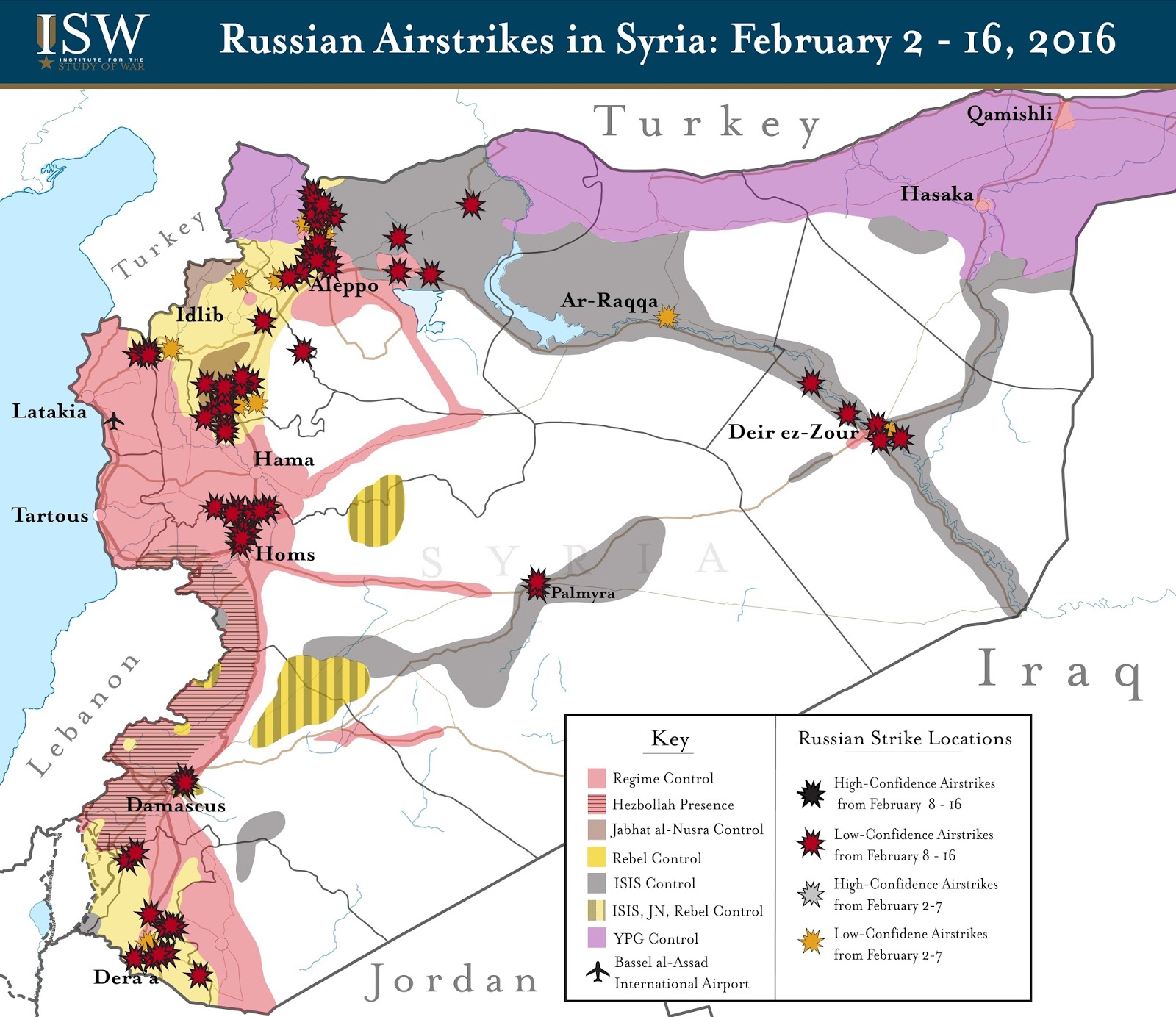
I don't know much about the ISW so I am not sure if there maps are an accurate representation of what is going on in Syria at the moment. However, I have noticed for awhile that al-Nusra is often shown as controlling these parts of Northern Idlib. Perhaps a discussion similar to this one has already been raised about incorporating ISW data in this map. In any case, just thought it would be worthwhile to bring it up. --Donenne (talk) 14:54, 25 February 2016 (UTC)
Scale[edit]
It would be nice if anyone added a scale. Thanks in advance. --Edroeh 13:00, 26 February 2016 (UTC)
Tal Abjad[edit]
Swiss newspaper NZZ states that "IS" is attacking Tal Abjad. How can that be if the town is surrounded by kurdish hold territory? --2A02:908:C32:ECC0:81A3:6725:B02B:898D 13:11, 27 February 2016 (UTC)
- They came from their sponsor's territory. Turkey...
картофагия[edit]
что за идиот постоянно карту меняет с очень большим разрешением? у него короткий член чтоли?
Block[edit]
Could someone block the map untill the editwar stops. thx in advance --2A02:908:C32:ECC0:4938:5504:7177:D0BE 22:56, 13 March 2016 (UTC)
- Was already protected some hours ago. --Denniss (talk) 23:01, 13 March 2016 (UTC)
Distinguish by factions in control rather than ethnicity[edit]
{{Edit request}} The purely ethnic distinction between "Kurds" and "Rebels" is factually incorrect, non-neutral and tends to further ethnic strife. Finally, we're distinguishing by power blocs, or factions in control rather than by ethnic or religious composition. The Federation of Northern Syria – Rojava is a pluriethnic region, so the color yellow should represent the Syrian Democratic Forces fully including the areas held by Jaysh al-Thuwar and other SDF members. --PanchoS (talk) 11:30, 19 March 2016 (UTC)
- As a possible compromise, possibly even the best solution, the areas held by the YPG could remain being marked in yellow, while areas held by non-YPG components of the SDF would be hatched in yellow and green. --PanchoS (talk) 11:35, 19 March 2016 (UTC)
- PanchoS I do not know much about the issues but I think I agree with you; however, {{Edit request}} should be used for text change, not graphics change. Please talk with authors of the graphics or create your own version. --Jarekt (talk) 02:25, 21 March 2016 (UTC)
- @Jarekt: This may be true for photographs or such, but a constantly updated map that contains a number of fundamentally contestable interpretations and assertions, yet claims to be NPOV – such as this map –, basically constitutes something like a Wikipedia article, not just a fundamentally neutral file. Procedures that have been established for mere depictions, are quite obviously inadequate for this kind of content. Finally, we don't want to host bunches of POV forks, nor do I have an issue with a particular editor that the two of us could possibly solve. A COM:RFC might be the most reasonable way to solve this kind of issues, though it doesn't seem to be regularly used for content disputes. Your feedback would be welcome! --PanchoS (talk) 16:26, 21 March 2016 (UTC)
- PanchoS, "bunches of POV forks" is the Commons answer to most POV type of disputes, because it shifts the discussion from Commons to wikipedia articles where it truly belongs. We assume that the best graphics will win, but is not ideal as it might create a lot of highly-POV files some need to choose from. May be the best approach here would be change file as you feel fit and upload under new name and use {{Edit request}} to request swap with the existing file, which should be quickly granted provided that there are no strong objections from other editors. Admins fulfilling {{Edit request}}s often do not have time/skills/software to modify or create files. BTW this file would be better as SVG. Oh and I just noticed that file is no longer protected, so anybody can edit it. --Jarekt (talk) 12:03, 23 March 2016 (UTC)
Al-Bukamal (close to the Iraqi border on the Euphrates)[edit]
Why is it marked as contested between the SAA and Daesh? I don't think there are any clashes going on. --Flying Desert Snow Leopard (talk) 15:38, 22 March 2016 (UTC)
)
- en:Talk:Cities_and_towns_during_the_Syrian_Civil_War/Archive_60#Al-Bukamal_tribal_uprising_against_ISIS. Esn (talk) 08:51, 1 April 2016 (UTC)
Retard[edit]
Retarded user named Bigles alwayas uploads filemap with highres, so he did it again and ignores all warnings, someone block permanently this idiot by ip or something
Sheikh Eissa[edit]
Please note that Sheikh Eissa between Marea and Tel Rifaat is FSA held rather than SDF held, we changed the module to reflect that fact NightShadeAEB (talk) 02:23, 28 March 2016 (UTC)
Qaryatayn[edit]
The map in this article (from a "pro-SAA" source) gives ISIS a whole stretch of territory south of Qaryatayn that's shown on this map as belonging to the SAA. Esn (talk) 08:49, 1 April 2016 (UTC)
More infos on map key needed[edit]
This map is very detailed (thanks for that), but it needs much more infos on its legend: date, link to commons, list of sources, explanations etc. Also, it could be cropped better, as there is a lot of empty surrounding (Turkey, mediterranean). Big cities should be marked larger. A downscaled overview version would be helpful. --Matthead (talk) 09:48, 3 April 2016 (UTC)
SAA enters Raqqa province[edit]
any update for map? link
Syrian Army farther into Raqqa province then shown in the image[edit]
The image shows SAA at the border of Raqqa province but they are actually much farther imto the province than shown here. This can be seen from the map shown at this link http://www.independent.co.uk/news/world/middle-east/isis-in-syria-government-forces-enter-raqqa-province-in-new-offensive-pushing-towards-isis-capital-a7065221.html by The Indepent. In the map, the Syrian Army is much deeper into the province and is near to Lake Assad and Tabqa. Please correct the image of the civil war. 117.199.93.126 23:53, 5 June 2016 (UTC)
Manbij[edit]
Is Manbij held by Daesh? Then it is probably sieged by Kurdish/SDF forces and had to be encircled on the map. Or did it fell to the Kurdish/SDF forces? Then it must be yellow. --2A02:908:C30:3680:6430:B462:6D9:6D29 05:34, 21 June 2016 (UTC)
- It was besieged for a while, now it's almost entirely kurdish. Basically the entire map is about a month out of date. Banak (talk) 23:09, 6 August 2016 (UTC)
- Flip, was looking at wrong map. Sieged implies there's not fighting in the city itself rather that it is just surrounded, here the fighting is in the heart of the city, which has nearly fallen to the SDF Banak (talk) 23:12, 6 August 2016 (UTC)
Colour[edit]
Which colour has the territory which is occupied by Turkey? --2A02:908:C30:3680:8DFE:1435:416E:DA73 08:45, 29 August 2016 (UTC)
- None. Iirc turkey is backing rebels with its forces but not occupying anything, but regardless this map hasn't been updated since then. Banak (talk) 07:51, 30 August 2016 (UTC)
How to update?[edit]
I'm looking to update this map, as it's quite outdated, but I have no idea how to do so. The previous instructions (from 2014) are no longer usable. How do I update this map? Nhauer (talk) 18:24, 23 January 2017 (UTC)