Category:Angus
Jump to navigation
Jump to search
Council areas (municipalities) of Scotland: Aberdeen · Aberdeenshire · Angus · Argyll and Bute · Clackmannanshire · Dumfries and Galloway · Dundee · East Ayrshire · East Dunbartonshire · East Lothian · East Renfrewshire · Edinburgh · Falkirk · Fife · Glasgow · Highland · Inverclyde · Midlothian · Moray · North Ayrshire · North Lanarkshire · Outer Hebrides · Orkney Islands · Perth and Kinross · Renfrewshire · Scottish Borders · Shetland Islands · South Ayrshire · South Lanarkshire · Stirling · West Dunbartonshire · West Lothian
Traditional counties (shires) of Scotland: Aberdeenshire · Angus · Argyll · Ayrshire · Banffshire · Berwickshire · Buteshire · Caithness · Clackmannanshire · Cromartyshire · Dumbartonshire · Dumfriesshire · East Lothian · Fife · Inverness-shire · Kincardineshire · Kinross-shire · Kirkcudbrightshire · Lanarkshire · Midlothian · Moray · Nairnshire · Orkney Islands · Peeblesshire · Perthshire · Renfrewshire · Ross-shire · Roxburghshire · Selkirkshire · Shetland Islands · Stirlingshire · Sutherland · West Lothian · Wigtownshire
council area of Scotland     | |||||
| Upload media | |||||
| Instance of |
| ||||
|---|---|---|---|---|---|
| Part of |
| ||||
| Location |
| ||||
| Capital | |||||
| Legislative body |
| ||||
| Headquarters location | |||||
| Population |
| ||||
| Area |
| ||||
| Different from | |||||
| official website | |||||
 | |||||


Subcategories
This category has the following 27 subcategories, out of 27 total.
A
- Aerial photographs of Angus (6 F)
C
E
G
H
I
N
P
- Panoramics of Angus (5 F)
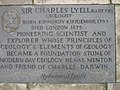
- Plaques in Angus (16 F)
- Playgrounds in Angus (2 F)
- Postcards of Angus (5 F)
S
- Sculptures in Angus (2 F)
T
V
Media in category "Angus"
The following 200 files are in this category, out of 486 total.
(previous page) (next page)-
 Flag of Angus.png 2,000 × 1,200; 334 KB
-
 31, 33 North Esk Road, Montrose.jpg 3,648 × 2,736; 4.01 MB
-
 500px photo (34238220).jpeg 900 × 675; 414 KB
-
 A roadrunner^ - geograph.org.uk - 258495.jpg 640 × 640; 101 KB
-
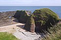
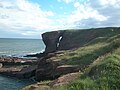
 A towering stack at Rickle Craig - geograph.org.uk - 6324483.jpg 5,472 × 3,648; 7.55 MB
-
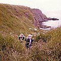
 A Weary Trek - geograph.org.uk - 5839282.jpg 480 × 640; 522 KB
-

-
 Angus coast path - geograph.org.uk - 5404510.jpg 1,024 × 576; 344 KB
-
 Angus coast path, Seaton - geograph.org.uk - 5404503.jpg 1,024 × 683; 375 KB
-
 Angus coastline - geograph.org.uk - 5404505.jpg 1,024 × 683; 369 KB
-
 Angus Council 2017.svg 360 × 185; 2 KB
-
 Angus Council Current.svg 360 × 185; 2 KB
-
 Angus, UK - panoramio (2).jpg 5,184 × 3,888; 7.11 MB
-
 Angus, UK - panoramio (3).jpg 5,184 × 3,888; 7.48 MB
-
 Angus, UK - panoramio (4).jpg 5,184 × 3,888; 6.68 MB
-
 Angus, UK - panoramio (5).jpg 5,184 × 3,888; 5.73 MB
-
 AngusCouncilCompositionMay2022.svg 360 × 185; 3 KB
-
 AngusCouncilSeatComposition.svg 360 × 185; 2 KB
-
 Auchertyre Hill - panoramio.jpg 4,608 × 3,072; 7.75 MB
-
-
 Back Boath - geograph.org.uk - 6188795.jpg 5,184 × 3,888; 5.4 MB
-
 Baird-James Carson MBE-1943.jpg 966 × 1,200; 142 KB
-
 Baird-Montrose from Ferryden-1941.jpg 1,200 × 910; 168 KB
-
 Barry Sands - geograph.org.uk - 2478958.jpg 3,648 × 2,736; 5 MB
-
 Barry Sands - geograph.org.uk - 5113334.jpg 640 × 480; 65 KB
-
 Beach at Carlingheugh Bay - geograph.org.uk - 5916622.jpg 1,024 × 575; 152 KB
-
 Beach at Lunan Bay - geograph.org.uk - 6022178.jpg 1,024 × 576; 284 KB
-
 Beach below Usan - geograph.org.uk - 1968500.jpg 640 × 480; 91 KB
-
 Beach south of West Links, Arbroath - geograph.org.uk - 3061862.jpg 1,024 × 681; 86 KB
-
 Beach south of West Links, Arbroath - geograph.org.uk - 3061868.jpg 1,024 × 681; 103 KB
-
 Beach, Lunan Bay - geograph.org.uk - 6022080.jpg 1,024 × 576; 275 KB
-
 Beach, West Links, Arbroath - geograph.org.uk - 6160005.jpg 2,000 × 1,333; 302 KB
-
 Beech trees, Auchnacree - geograph.org.uk - 1187464.jpg 427 × 640; 232 KB
-
 Blowhole near Usan viewed in a southwesterly direction - geograph.org.uk - 5261147.jpg 3,264 × 2,448; 2.68 MB
-
 Boddin Point - geograph.org.uk - 5555509.jpg 1,600 × 1,200; 351 KB
-

-
 Braidlees, Burn of Milton - geograph.org.uk - 1618261.jpg 640 × 427; 187 KB
-
 Bridge - panoramio (132).jpg 4,608 × 3,072; 7.87 MB
-
 Bridge over river South Esk . - geograph.org.uk - 2138888.jpg 640 × 480; 82 KB
-
 Buckie Den Viaduct - geograph.org.uk - 1978165.jpg 640 × 480; 38 KB
-
 Buried Rocks - geograph.org.uk - 4258236.jpg 640 × 479; 408 KB
-
 Burn of Cochlie - geograph.org.uk - 1777023.jpg 640 × 359; 95 KB
-
 Burn of Cochlie - geograph.org.uk - 1777038.jpg 640 × 480; 145 KB
-
 Burrdock Seed heads - geograph.org.uk - 1131389.jpg 635 × 640; 118 KB
-
 Cairn on Drovers Road - geograph.org.uk - 1232737.jpg 640 × 426; 79 KB
-
 Carious Weathering - geograph.org.uk - 4264653.jpg 640 × 444; 517 KB
-
 Carlingheugh Bay - geograph.org.uk - 3089892.jpg 2,048 × 1,536; 950 KB
-
 Carlingheugh Bay - geograph.org.uk - 4300422.jpg 4,608 × 3,456; 4.91 MB
-
 Carlingheugh Bay - geograph.org.uk - 5417030.jpg 640 × 426; 88 KB
-
 Carlingheugh Bay Cliffs - geograph.org.uk - 5417555.jpg 640 × 436; 93 KB
-
 Carlingheugh Bay north of Arbroath - geograph.org.uk - 1821653.jpg 1,600 × 1,200; 606 KB
-
 Castle Gate - geograph.org.uk - 5417087.jpg 640 × 380; 67 KB
-
 Castle Gate natural arch - geograph.org.uk - 6302413.jpg 5,256 × 3,503; 6.06 MB
-
 Castle Gate, Carlingheugh Bay - geograph.org.uk - 5404497.jpg 1,024 × 683; 392 KB
-
 Castle Gate, Carlingheugh Bay near Arbroath - geograph.org.uk - 5232510.jpg 5,184 × 2,920; 4.58 MB
-
 Cateran Trail near Kilry - geograph.org.uk - 1098366.jpg 640 × 485; 100 KB
-
 Cave in cliffs at Lunan Bay - geograph.org.uk - 3367113.jpg 1,024 × 717; 286 KB
-
 Cliffs at north end of Lunan Bay - geograph.org.uk - 5555532.jpg 1,600 × 1,067; 378 KB
-
 Cliffs in the sunshine - geograph.org.uk - 4123622.jpg 2,048 × 1,536; 1.56 MB
-
 Cliffs near Auchmithie - geograph.org.uk - 5416176.jpg 640 × 456; 81 KB
-
 Cliffs Near Rumness - geograph.org.uk - 3137916.jpg 4,288 × 3,216; 3.56 MB
-
 Climbers, Angus coast - geograph.org.uk - 5401147.jpg 1,024 × 683; 468 KB
-
-
 Coast at Rumkemno, north of Auchmithie - geograph.org.uk - 3725650.jpg 1,024 × 681; 173 KB
-
 Coast, Lunan Bay - geograph.org.uk - 6022067.jpg 1,024 × 683; 466 KB
-
 Coastal erosion at Masons' Cave - geograph.org.uk - 5669321.jpg 3,648 × 5,472; 4.79 MB
-
 Coat of arms of the Angus Area Council.svg 461 × 740; 320 KB
-
 Complete Rainbow - geograph.org.uk - 6290506.jpg 640 × 474; 217 KB
-
 Corbie Knowe - geograph.org.uk - 1978304.jpg 640 × 480; 126 KB
-
 Council advertising, Carnoustie - geograph.org.uk - 1490621.jpg 640 × 480; 79 KB
-
 Cove Haven - geograph.org.uk - 5178077.jpg 2,560 × 1,920; 828 KB
-
 Cove Haven and Castle Gate - geograph.org.uk - 5916611.jpg 1,024 × 575; 164 KB
-
 Crags and coast path, Arbroath - geograph.org.uk - 5401145.jpg 1,024 × 576; 339 KB
-
 Craig Soales - geograph.org.uk - 1223025.jpg 640 × 481; 109 KB
-
 Craigmill Burn - geograph.org.uk - 6230962.jpg 1,024 × 768; 131 KB
-
 Cuthile Harbour, Ethie - geograph.org.uk - 3725406.jpg 1,024 × 682; 203 KB
-
 Dalhousie Court - geograph.org.uk - 1490661.jpg 640 × 480; 69 KB
-
 Den, Auchnacree - geograph.org.uk - 1187468.jpg 640 × 427; 213 KB
-
 Dipping strata near the Deil's Heid, Seaton Cliffs, Arbroath - geograph.org.uk - 5507978.jpg 3,264 × 2,448; 2.53 MB
-
 Drystane Dykes near Rottal - geograph.org.uk - 1744747.jpg 640 × 427; 295 KB
-
 Duncan's Door by The Deil's Heid - geograph.org.uk - 5669260.jpg 5,472 × 3,648; 6.46 MB
-
 Dune vegetation - geograph.org.uk - 2935911.jpg 2,048 × 1,536; 512 KB
-
 Dune vegetation - geograph.org.uk - 2935914.jpg 2,048 × 1,536; 420 KB
-
 Dune's edge and beach - geograph.org.uk - 2259581.jpg 640 × 480; 102 KB
-
 Dune's edge and sandy beach - geograph.org.uk - 2259586.jpg 640 × 480; 103 KB
-
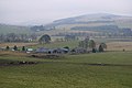
 East Hills farmhouse near Redford by Forfar, Angus - geograph.org.uk - 5943886.jpg 5,184 × 3,888; 6.9 MB
-
 Edzell - panoramio - Orit Kislev.jpg 5,312 × 2,988; 4.67 MB
-
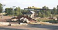
 Electricity sub-station - geograph.org.uk - 511936.jpg 640 × 480; 120 KB
-
 Empty roads (Unsplash).jpg 4,000 × 6,000; 4.44 MB
-
 Eroded Arch - geograph.org.uk - 5801495.jpg 4,272 × 2,848; 3.41 MB
-
 Eroded coast at Rickle Craig - geograph.org.uk - 5862470.jpg 3,264 × 2,448; 3.1 MB
-
 Eroded peat, East Cairn - geograph.org.uk - 1775771.jpg 640 × 359; 104 KB
-
 Eroded peat, Horse Holm - geograph.org.uk - 1776185.jpg 640 × 480; 86 KB
-
 Erosional features of cliffs at Lunan Bay - geograph.org.uk - 5662891.jpg 3,264 × 2,448; 2.52 MB
-
 Fahrt von Dunnotar Castle nach Dundee (24745084798).jpg 1,920 × 1,275; 336 KB
-
 Fahrt von Dunnotar Castle nach Dundee (37729437715).jpg 1,920 × 1,275; 368 KB
-
 Fahrt von Dunnotar Castle nach Dundee (38584799522).jpg 1,920 × 1,275; 421 KB
-
 Fault in the Cliff - geograph.org.uk - 4258196.jpg 480 × 640; 466 KB
-
 Fault line at the Dark Cave - geograph.org.uk - 6292015.jpg 2,448 × 3,264; 3.62 MB
-
 Fields, Acharn - geograph.org.uk - 1780140.jpg 534 × 800; 208 KB
-
 Fire Trainer - geograph.org.uk - 1141379.jpg 640 × 427; 41 KB
-
 Fishing near Corbie Knowe, Lunan Bay - geograph.org.uk - 3725561.jpg 1,024 × 682; 188 KB
-
 Fishing off Seaton Cliffs, Arbroath - geograph.org.uk - 2165405.jpg 800 × 418; 238 KB
-
 Fishing on the beach at Lunan Bay - geograph.org.uk - 3725592.jpg 1,024 × 681; 118 KB
-
 Fissured promontory at Seaton Cliffs - geograph.org.uk - 5506963.jpg 3,264 × 2,448; 2.38 MB
-
 Fissured Promontory near the Deil's Heid - geograph.org.uk - 6165358.jpg 3,264 × 2,448; 2.57 MB
-
 Forest track, Cramie - geograph.org.uk - 1578354.jpg 640 × 359; 126 KB
-
 From the river - panoramio.jpg 4,608 × 3,072; 7.05 MB
-
 Glacial deposits in Glen Logie - geograph.org.uk - 1571834.jpg 640 × 480; 127 KB
-
 Graham of Montrose COA.svg 506 × 522; 24 KB
-
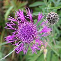 Greater Knapweed (Centaurea scbiosa) - geograph.org.uk - 5496722.jpg 640 × 640; 564 KB
-
 Grit box, Glen Prosen - geograph.org.uk - 1195539.jpg 640 × 480; 119 KB
-
 Gwesk Hillock. - geograph.org.uk - 117815.jpg 640 × 480; 49 KB
-
 Ha-Ha at Pitmuies - geograph.org.uk - 1443555.jpg 640 × 480; 132 KB
-
 Haar - geograph.org.uk - 3080637.jpg 640 × 468; 294 KB
-
 Hill of Strone - geograph.org.uk - 1577332.jpg 640 × 359; 87 KB
-
 Hill track on Hill of Turret - geograph.org.uk - 1048058.jpg 640 × 427; 54 KB
-
-
 Hogweed (Heracleum sphondylium) - geograph.org.uk - 910840.jpg 640 × 624; 276 KB
-
 Hogweed Isle - geograph.org.uk - 5127469.jpg 4,272 × 2,848; 3.99 MB
-
 Ice crystals - geograph.org.uk - 704467.jpg 640 × 480; 143 KB
-
 Ice on a birch in central Carnoustie - geograph.org.uk - 1162996.jpg 281 × 640; 45 KB
-
 In the Glen - panoramio.jpg 4,608 × 3,072; 8.75 MB
-
 Inlet by which the sea enters Castle Gate arch - geograph.org.uk - 6307294.jpg 5,472 × 3,648; 7.22 MB
-
 Justinhaugh (8).jpg 1,200 × 900; 260 KB
-
 Kame, Needs - geograph.org.uk - 361986.jpg 640 × 518; 82 KB
-
 Kirk Loch - geograph.org.uk - 4110559.jpg 640 × 422; 414 KB
-
 Kirk Loch - geograph.org.uk - 6021460.jpg 1,024 × 576; 319 KB
-
-
 Knowehead from the Cateran Trail - geograph.org.uk - 1097964.jpg 640 × 427; 71 KB
-
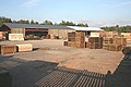 Ladywell Sawmill - geograph.org.uk - 222359.jpg 640 × 427; 220 KB
-
 Ladywell Sawmill - geograph.org.uk - 222361.jpg 640 × 329; 197 KB
-

-
 Lamb-Baird-1932.jpg 779 × 1,200; 73 KB
-
 Lava at Usan with a pillow like appearance - geograph.org.uk - 6255418.jpg 5,472 × 3,648; 7.09 MB
-

-
-
 Loch Lee - panoramio.jpg 4,546 × 2,976; 5.87 MB
-
 Loch Lee the river bends - panoramio.jpg 4,608 × 3,072; 6.07 MB
-
 Loch lee, the boat house - panoramio.jpg 4,608 × 3,072; 8.7 MB
-
 Looking at Hill of Saughs - panoramio.jpg 4,608 × 3,072; 6.36 MB
-
 Looking back to Loch Lee - panoramio.jpg 4,520 × 2,936; 6.57 MB
-
 Looking down Glen Mark - panoramio.jpg 4,608 × 3,072; 5.05 MB
-
 Looking North - panoramio (8).jpg 4,608 × 3,072; 5.93 MB
-
 Looking towards Red Head from Prail Castle - geograph.org.uk - 3986059.jpg 1,024 × 702; 146 KB
-
 Lower North Water Bridge - geograph.org.uk - 2242451.jpg 1,500 × 975; 391 KB
-
 Lunan Bay - geograph.org.uk - 1964052.jpg 640 × 467; 190 KB
-
 Lunan Bay - geograph.org.uk - 1964077.jpg 640 × 466; 284 KB
-
 Lunan Bay - geograph.org.uk - 1978283.jpg 640 × 480; 36 KB
-
 Lunan Bay - geograph.org.uk - 2055335.jpg 640 × 427; 254 KB
-
 Lunan Bay - panoramio.jpg 1,400 × 935; 217 KB
-
 Lunan bay - panoramio.jpg 1,400 × 935; 226 KB
-
 Lunan Bay from the south - geograph.org.uk - 3725598.jpg 1,024 × 681; 187 KB
-
 Lunan Bay monster. - panoramio.jpg 1,600 × 1,068; 240 KB
-
 Lunan Bay near braehead - panoramio.jpg 1,600 × 1,068; 246 KB
-
 Lunan Bay. - panoramio.jpg 1,600 × 1,068; 291 KB
-
 Lunan Headland - geograph.org.uk - 5801491.jpg 4,272 × 2,848; 2.25 MB
-
 Masons' Cave by Cove Haven, Arbroath - geograph.org.uk - 5510138.jpg 3,264 × 2,448; 2.44 MB
-
 Masons' Cave entrance, Arbroath - geograph.org.uk - 5520527.jpg 5,472 × 3,648; 2.68 MB
-
 Memories of "Chris" - panoramio.jpg 4,608 × 3,072; 9.43 MB
-
 Midsummer Sunset - geograph.org.uk - 2496049.jpg 640 × 470; 292 KB
-
 Military Defences - geograph.org.uk - 1979692.jpg 640 × 480; 63 KB
-
 Monifieth Beach.jpg 1,200 × 900; 175 KB
-
 Montrose Basin - geograph.org.uk - 1966787.jpg 640 × 480; 50 KB
-
 Montrose Basin - panoramio.jpg 3,008 × 2,000; 2.69 MB
-
 Montrose Basin south of Heathbank - geograph.org.uk - 3468777.jpg 640 × 480; 301 KB
-
 Moon Jellyfish on Lunan Bay Beach, Angus - geograph.org.uk - 3306627.jpg 1,024 × 719; 190 KB
-
 Moorland, Horse Holm - geograph.org.uk - 1776189.jpg 640 × 346; 65 KB
-
 More red deer - geograph.org.uk - 180498.jpg 640 × 480; 78 KB
-
 Mount Bouie - geograph.org.uk - 1573121.jpg 640 × 359; 95 KB
-
 Mouth of the Burn - geograph.org.uk - 4258261.jpg 640 × 404; 192 KB
-
 Mouth of the Keilor Burn - geograph.org.uk - 3167991.jpg 640 × 417; 330 KB
-
 MP499 - Sustrans Millennium Milepost.jpg 2,304 × 4,096; 1.1 MB
-
 MP988 - Sustrans Millennium Milepost.jpg 2,304 × 4,096; 2.04 MB
-
 Mud-slide on Seaton Cliffs in Carlingheugh Bay - geograph.org.uk - 6298346.jpg 3,264 × 2,448; 1.44 MB
-
 Mud-slide on Seaton Cliffs, Arbroath - geograph.org.uk - 6297702.jpg 3,264 × 2,448; 1.23 MB
-
 Natural Arch - geograph.org.uk - 3080605.jpg 480 × 640; 418 KB
-
 Natural Arch - geograph.org.uk - 4258268.jpg 480 × 640; 440 KB
-
 Natural arch Castle Gate, Carlingheugh Bay near Arbroath - geograph.org.uk - 5232512.jpg 5,184 × 2,920; 4.9 MB
-
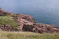
 Natural cliff wall at Rickle Craig - geograph.org.uk - 6324325.jpg 5,472 × 3,648; 4.9 MB
-
 Needle E'e - geograph.org.uk - 5178069.jpg 2,560 × 1,920; 1.23 MB
-
 North End of Lunan Beach - geograph.org.uk - 2312335.jpg 1,600 × 907; 308 KB
-
 North headland - geograph.org.uk - 4123630.jpg 2,048 × 1,536; 1.56 MB
-
 North of Carlingheugh Bay - geograph.org.uk - 5417025.jpg 640 × 403; 85 KB
-
 North Water Bridges - geograph.org.uk - 2003950.jpg 2,560 × 1,920; 1.8 MB
-
 Northerly Gale - geograph.org.uk - 2055304.jpg 640 × 395; 234 KB
-
 Old railway path - panoramio.jpg 4,608 × 3,072; 10.29 MB
-
 Old Red Sandstone - geograph.org.uk - 4264649.jpg 640 × 480; 477 KB
-
 On the Cateran Trail above Glen Isla - geograph.org.uk - 1097956.jpg 640 × 480; 104 KB
-
 On the Cateran Trail near Loanhead - geograph.org.uk - 1112568.jpg 640 × 360; 66 KB
-
 On the Cateran Way - geograph.org.uk - 1437326.jpg 640 × 480; 77 KB
-
 Over the rocks and far away - Flickr - Neillwphoto.jpg 3,730 × 5,763; 14.99 MB
-
 Paragliding at Whiting Ness - geograph.org.uk - 644609.jpg 640 × 480; 38 KB
-
 Path to Auchnacree - geograph.org.uk - 1187459.jpg 427 × 640; 243 KB
-
 Photographer on the beach - geograph.org.uk - 2258463.jpg 640 × 480; 97 KB
-
 Pinetum at Glamis - geograph.org.uk - 401087.jpg 640 × 480; 124 KB
-
 Pinnacle and a Peephole - geograph.org.uk - 4258230.jpg 640 × 480; 284 KB
-

-
 Polytunnels, East Scryne - geograph.org.uk - 1659370.jpg 640 × 480; 96 KB
-
 Pool and Pillar - geograph.org.uk - 4258212.jpg 640 × 480; 334 KB

.jpeg)


.jpg)
.jpg)
.jpg)
.jpg)


.jpg)


.jpg)
.jpg)
.jpg)


_-_geograph.org.uk_-_5496722.jpg)


_-_geograph.org.uk_-_910840.jpg)


.jpg)


,_south_of_West_Links,_Arbroath_-_geograph.org.uk_-_3061892.jpg)


.jpg)


.jpg)