File:1947 Zhonghua Minguo Quantu.png
跳转到导航
跳转到搜索

本预览的尺寸:800 × 526像素。 其他分辨率:320 × 210像素 | 640 × 420像素 | 1,024 × 673像素 | 1,280 × 841像素 | 3,044 × 2,000像素。
原始文件 (3,044 × 2,000像素,文件大小:13.79 MB,MIME类型:image/png)
说明
说明
添加一行文字以描述该文件所表现的内容
1947 map of the Republic of China and Outer Mongolia
| 描述 |
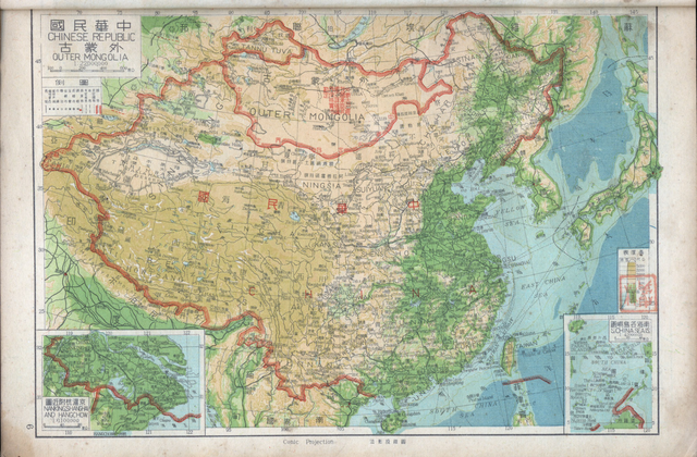
中文(简体):1947年出版的中华民国地图和外蒙古地图。图中的南海诸岛的名称仍使用旧称。1947年中华民国地图,此图中注明「外蒙古已经我国承认其独立」。此图中南海四沙仍然沿用旧名。
English: Map of the Chinese Republic and Outer Mongolia published in 1947. The names of the South China Sea Islands (Nanhai Zhudao) in the map still used old names. At the top of the map in 1947, which indicates that Outer Mongolia has been recognized for independence by the government of the Republic of China, and show the border between China and Mongolia. |
|||
| 日期 | ||||
| 来源 | https://www.nansha.org.cn/maps/3/1947_ROC_Map.jpg | |||
| 作者 | ||||
| 授权 (二次使用本文件) |
|


文件历史
点击某个日期/时间查看对应时刻的文件。
| 日期/时间 | 缩略图 | 大小 | 用户 | 备注 | |
|---|---|---|---|---|---|
| 当前 | 2019年5月7日 (二) 02:18 | | 3,044 × 2,000(13.79 MB) | Tm(留言 | 贡献) | Reverted to version as of 12:27, 6 May 2008 (UTC) |
| 2019年5月7日 (二) 00:12 |  | 1,600 × 1,119(3.35 MB) | Aerbaniya(留言 | 贡献) | edit | |
| 2008年5月6日 (二) 12:27 |  | 3,044 × 2,000(13.79 MB) | Shibo77(留言 | 贡献) | 中文说明: 为1947年出版的中华民国地图和南洋群岛图。图中的南海诸岛的名称仍使用旧称。1947年中华民国地图,此图中注明外蒙古已经被民国政府批准独立。此图中南海四沙仍然沿用旧名。 {{P |
您不可以覆盖此文件。
文件用途
以下3个页面使用本文件:
全域文件用途
以下其他wiki使用此文件:
- ca.wikipedia.org上的用途
- de.wikipedia.org上的用途
- en.wikipedia.org上的用途
- en.wiktionary.org上的用途
- es.wikipedia.org上的用途
- fr.wikipedia.org上的用途
- id.wikipedia.org上的用途
- ja.wikipedia.org上的用途
- ko.wikipedia.org上的用途
- mnw.wiktionary.org上的用途
- no.wikipedia.org上的用途
- sv.wikipedia.org上的用途
- www.wikidata.org上的用途
- zh-yue.wikipedia.org上的用途
- zh.wikipedia.org上的用途