File:Claude Bernou Carte de lAmerique septentrionale.jpg
Původní soubor (3 841 × 3 641 pixelů, velikost souboru: 5,86 MB, MIME typ: image/jpeg)
Popisky
Popisky
Popis[editovat]
| Popis |
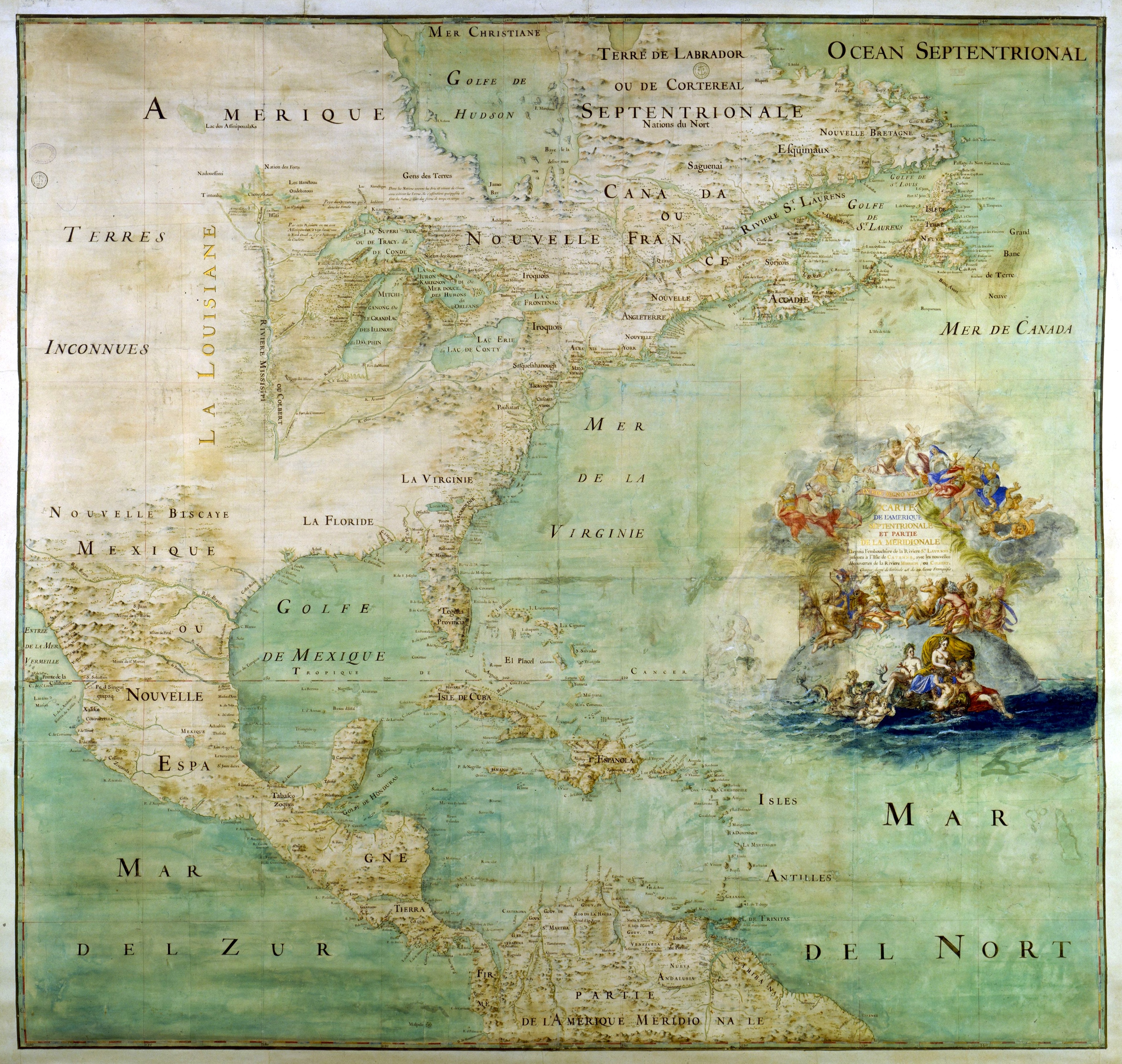
English: Map of the northern part and parts of the southern parts of the America, from the mouth of the Saint Laurent River to the Island of Cayenne,with the new discoveries of the Mississipi (or Colbert) River. This map shows the results of the expeditions of Father Marquette and L. Jolliet (1673) and the Cavelier de la Salle expedition in the Mississipi valley. The map shows three forts built between 1679 and 1680: Conty fort (near Niagara Falls), Miamis Fort (south of Michigan lake), and Crèvecœur fort (Left bank of the Illinois River). Mississippi river course is only shown upstream of Ohio confluence.
Français : Carte de l'Amérique septentrionale et partie de la méridionale depuis l'embouchure de la rivière St Laurens jusqu'à l'isle de Cayenne avec les nouvelles découvertes de la rivière de Mississipi ou Colbert [attribuée à l'abbé Bernou]. Montre le résultat des expéditions du is (au sud du Lac Michigan), fort Crèvecœur (rive gauche de l'Illinois). Le cours du Mississippi n'est figuré que jusqu'à sa confluence avec l'Ohio. Collation : 1 carte, ms. col. , 163 × 147 cm
Čeština: Mapa severní části a částí jižních částí Ameriky, od ústí řeky Saint Laurent po ostrov Cayenne, s novými objevy řeky Mississipi (neboli Colbert). Tato mapa ukazuje výsledky expedic otce Marquette a L. Jolliet (1673) a expedice Cavelier de la Salle v údolí Mississipi. Mapa ukazuje tři pevnosti postavené v letech 1679 až 1680: pevnost Conty (poblíž Niagarských vodopádů), pevnost Miamis (jižně od Michiganského jezera) a pevnost Crèvecœur (levý břeh řeky Illinois). Kurz řeky Mississippi je zobrazen pouze před soutokem s řekou Ohio. |
| Datum | cca 1681 |
| Zdroj | Uploaded by David.Monniaux |
| Tvůrce |
Bernou, Claude (b. 16..–d. 17..), Abbot |
| Georeferencing | If inappropriate please set warp_status = skip to hide. |
|
Tento soubor byl vybrán jako obrázek dne na 22. března 2006. Nadpis tohoto obrázku: Čeština: Mapa Severní Ameriky ze 17. století. Další jazyky:
Alemannisch: Alti Kart vun Nordamerika Čeština: Mapa Severní Ameriky ze 17. století. Deutsch: Frühe Karte von Nordamerika English: Early map of North America Español: Antiguo mapa de América del Norte Français : Ancienne carte de l'Amérique du nord Galego: mapa de America do Norte Italiano: Antica mappa dell'America del Nord Lëtzebuergesch: Historesch Kaart vun Nordamerika. Magyar: Észak-Amerika XVII. századi térképe Norsk nynorsk: Tidleg kart over Nord-Amerika. Polski: Siedemnastowieczna mapa Ameryki Północnej Português: Mapa antigo da América do Norte Suomi: Vanha Pohjois-Amerikan kartta. Български: Ранна карта на Северна Америка (17 век) Русский: Древняя карта Северной Америки 日本語: 初期の北アメリカの地図 中文: 北美17世纪时的地图。 |
Licence[editovat]
Tento obrázek je volným dílem, protože se jedná jen o mechanický sken či fotokopii originálu volného díla anebo se jedná o dílo, jež se evidentně takovému skenu či fotokopii podobá natolik, že nemůže požívat ochrany autorského práva. Originál samotný je volným dílem z následujícího důvodu:
This tag is designed for use where there may be a need to assert that any enhancements (eg brightness, contrast, colour-matching, sharpening) are in themselves insufficiently creative to generate a new copyright. It can be used where it is unknown whether any enhancements have been made, as well as when the enhancements are clear but insufficient. For known raw unenhanced scans you can use an appropriate {{PD-old}} tag instead. For usage, see Commons:When to use the PD-scan tag.  | ||||
Historie souboru
Kliknutím na datum a čas se zobrazí tehdejší verze souboru.
| Datum a čas | Náhled | Rozměry | Uživatel | Komentář | |
|---|---|---|---|---|---|
| současná | 29. 6. 2012, 14:13 | | 3 841 × 3 641 (5,86 MB) | Paris 16 (diskuse | příspěvky) | cropped |
| 15. 5. 2005, 20:12 |  | 3 946 × 3 697 (6,2 MB) | David.Monniaux (diskuse | příspěvky) | ||
| 15. 5. 2005, 18:23 |  | 3 792 × 3 576 (5,89 MB) | David.Monniaux (diskuse | příspěvky) | {{Français}} '''Auteur :''' Bernou, Claude (16..-17..?), abbé '''Titre :''' ''Carte de l'Amérique septentrionale et partie de la méridionale depuis l'embouchure de la rivière St Laurens jusqu'à l'isle de Cayenne avec les nouvelles décou |
Tento soubor nemůžete přepsat.
Využití souboru
Na Commons na soubor odkazují tyto stránky:
- Atlas of Central America
- Atlas of North America
- Atlas of colonialism
- Joseph Bologne de Saint-George
- Old maps
- User:John Cummings/gallerytest
- User:Lilliputian~commonswiki
- User:Manuel González Olaechea/Antique maps
- User:Mats Halldin~commonswiki/Gallery 3
- Commons:Featured picture candidates/Image:Claude Bernou Carte de lAmerique septentrionale.jpg
- Commons:Featured picture candidates/Log/May 2005
- Commons:Featured pictures/Non-photographic media/Maps
- Commons:Featured pictures/chronological/2005-A
- Commons:Potd/2006-03 (fr)
- Commons:Potd/2006-03 (pl)
- Commons:Potd/2006-03 (pt)
- Commons:Potd/2006-03 (tr)
- Commons talk:Featured picture candidates/Archive candidate list
- Template:Potd/2006-03
- Template:Potd/2006-03-22
- Template:Potd/2006-03-22 (als)
- Template:Potd/2006-03-22 (bg)
- Template:Potd/2006-03-22 (cs)
- Template:Potd/2006-03-22 (de)
- Template:Potd/2006-03-22 (en)
- Template:Potd/2006-03-22 (es)
- Template:Potd/2006-03-22 (fi)
- Template:Potd/2006-03-22 (fr)
- Template:Potd/2006-03-22 (gl)
- Template:Potd/2006-03-22 (hu)
- Template:Potd/2006-03-22 (it)
- Template:Potd/2006-03-22 (ja)
- Template:Potd/2006-03-22 (lb)
- Template:Potd/2006-03-22 (nn)
- Template:Potd/2006-03-22 (pl)
- Template:Potd/2006-03-22 (pt)
- Template:Potd/2006-03-22 (ru)
- Template:Potd/2006-03-22 (zh-hans)
Globální využití souboru
Tento soubor využívají následující wiki:
- Využití na af.wikipedia.org
- Využití na ar.wikipedia.org
- Využití na azb.wikipedia.org
- Využití na az.wikipedia.org
- Využití na br.wikipedia.org
- Využití na ca.wikipedia.org
- Využití na cs.wikipedia.org
- Využití na de.wikipedia.org
- Využití na en.wikipedia.org
- New France
- Médard des Groseilliers
- Illinois Country
- Louisiana (New France)
- Spanish Texas
- Timeline of the European colonization of North America
- User:Cliché Online/New France
- French colonization of Texas
- Portal:Maps/Maps/Historical
- Portal:Maps/Maps/Historical/12
- Fort Crevecoeur
- List of French possessions and colonies
- Cartography of the United States
- Timeline of European imperialism
- Wikipedia:Featured picture candidates/Bernou's map of Nothern America
- Wikipedia:Featured picture candidates/March-2017
- Fort Saint-Louis (Texas)
- User:Falcaorib/Canada, United States and Mexico
- Využití na eo.wikipedia.org
- Využití na es.wikipedia.org
Zobrazit další globální využití tohoto souboru.
Metadata
- Old maps of New France
- 1680s maps of North America
- 1680s maps of the United States
- 1680s maps of Canada
- 1680s maps of the Caribbean
- Old maps of Spanish Texas
- Fort Crevecoeur (Illinois)
- The Carolinas
- Old maps of the Great Lakes
- Maps of the Iroquois
- History of indigenous peoples of the Great Lakes Region
- Susquehannock
- Powhatan