File:Flag map of the world.svg

Originaldatei (SVG-Datei, Basisgröße: 2.400 × 1.200 Pixel, Dateigröße: 6,49 MB)
Bildtexte
Kurzbeschreibungen
Beschreibung
| Beschreibung |
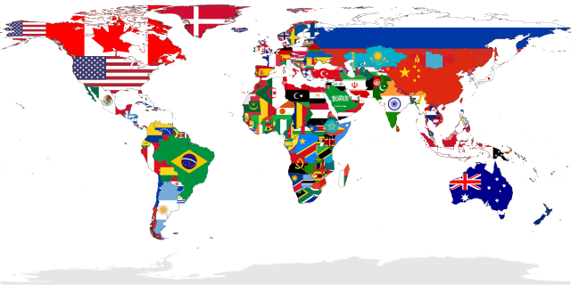
Deutsch: Eine Karte, die alle UN-Staaten mit ihrer Flagge zeigt. Das Gebiet der Westsahara ist grau eingefärbt, weil kein UN-Staat dieses Gebiet repräsentiert.
English: A map showing the flags of the world, in equirectangular projection. The countries shown are the members of the United Nations. Western Sahara is in light grey because it is considered to be a Non-Self-Governing Territory with no administration (source), therefore there is no UN member state flag to represent that place.
Español: Un mapa que muestra las banderas del mundo, en proyección equirrectangular. Los países que se muestran son miembros de las Naciones Unidas. El Sáhara Occidental está en gris claro porque se considera un territorio no autónomo sin administración, por lo tanto, no hay una bandera de un estado miembro de la ONU para representar ese lugar.
Français : Carte montrant les drapeaux du monde. Projection équirectangulaire. Les drapeaux présents correspondent aux membres des nations unies. En conséquences le sahara occidental est en gris, car considéré par l'ONU comme une territoire sans gouvernement autonome.
Українська: Мапа відображає всі країни світу, площі яких заповнені кольорами їхніх прапорів.
中文(繁體):本圖顯示的是全球聯合國會員國國家的國旗圖像,以全景圖方式顯示。非聯合國會員國的國家,不會在此圖中顯示其國旗。 |
| SVG‑Erstellung | Diese übergrosse Landkarte wurde mit Adobe Illustrator erstellt. und mit Inkscape. |
| Datum | |
| Quelle | Eigenes Werk |
| Urheber | |
| Georeferenzierung | If inappropriate please set warp_status = skip to hide. |
| Andere Versionen |
Abgeleitete Werke dieser Datei: |
Auszeichnungen
|

Deutsch: Dieses Bild wurde als Bild der Woche auf der tschechischen Wikipedia für die 17 Woche ausgewählt, 2018. English: This image was selected as a picture of the week on the Czech Wikipedia for 17th week, 2018. Français : Cette image est sélectionnée en tant qu’image de la semaine sur la Wikipédia Tchèque pour la 17e semaine de 2018. Italiano: Questa immagine è stata selezionata come Immagine della settimana su Wikipedia in ceco per la XVII settimana del 2018. Македонски: Сликава е избрана за слика на неделата на чешката Википедија за XVII недела од 2018 година. Русский: Эта иллюстрация была выбрана изображением недели в чешском разделе «Википедии» для недели номер 17 2018 года. Українська: Ця ілюстрація була вибрана зображенням тижня в чеському розділі «Вікіпедії» для тижня номер 17, 2018 року. |

|
Dieses Bild ist nach den Kriterien für wertvolle Bilder beurteilt worden und gilt als das hochwertigste auf Commons im Bereich: Flag maps of the world. Die Nominierung des Bildes ist nachzulesen unter Commons:Kandidaturen hochwertiger Bilder/Flag-map of the world.svg. |
Lizenz
| Ich, der Urheberrechtsinhaber dieses Werkes, veröffentliche es als gemeinfrei. Dies gilt weltweit. In manchen Staaten könnte dies rechtlich nicht möglich sein. Sofern dies der Fall ist: Ich gewähre jedem das bedingungslose Recht, dieses Werk für jedweden Zweck zu nutzen, es sei denn, Bedingungen sind gesetzlich erforderlich. |
Dateiversionen
Klicke auf einen Zeitpunkt, um diese Version zu laden.
| Version vom | Vorschaubild | Maße | Benutzer | Kommentar | |
|---|---|---|---|---|---|
| aktuell | 01:00, 6. Jan. 2023 | | 2.400 × 1.200 (6,49 MB) | JoKalliauer (Diskussion | Beiträge) | Reverted to version as of 18:19, 21 December 2022 (UTC), Template:FakeSVG |
| 16:29, 24. Dez. 2022 |  | 2.400 × 1.200 (1,01 MB) | Takiva (Diskussion | Beiträge) | . | |
| 18:19, 21. Dez. 2022 |  | 2.400 × 1.200 (6,49 MB) | Alexphangia (Diskussion | Beiträge) | Reverted to version as of 09:00, 24 February 2022 (UTC) | |
| 18:03, 16. Dez. 2022 |  | 512 × 256 (5,17 MB) | Pouyajabbarisani (Diskussion | Beiträge) | update iran | |
| 17:39, 16. Dez. 2022 |  | 2.400 × 1.200 (1,01 MB) | Pouyajabbarisani (Diskussion | Beiträge) | Reverted to version as of 23:32, 7 November 2022 (UTC) | |
| 22:05, 9. Nov. 2022 |  | 2.560 × 1.280 (1,42 MB) | ⵜⴰⴽⵉ (Diskussion | Beiträge) | Reverted to version as of 14:07, 7 November 2022 (UTC) | |
| 23:32, 7. Nov. 2022 |  | 2.400 × 1.200 (1,01 MB) | Golden (Diskussion | Beiträge) | Reverted to version as of 21:33, 29 October 2022 (UTC) | |
| 14:07, 7. Nov. 2022 |  | 2.560 × 1.280 (1,42 MB) | ⵜⴰⴽⵉ (Diskussion | Beiträge) | . | |
| 21:33, 29. Okt. 2022 |  | 2.400 × 1.200 (1,01 MB) | Takiva (Diskussion | Beiträge) | the flag of algeria | |
| 09:00, 24. Feb. 2022 |  | 2.400 × 1.200 (6,49 MB) | Supermæn (Diskussion | Beiträge) | fixed Imbros |
Du kannst diese Datei nicht überschreiben.
Dateiverwendung
Die folgenden 73 Seiten verwenden diese Datei:
- User:Adeletron 3030/botgalleries/Sports/2022 November 7-9/Overflow 1
- User:Chumwa/OgreBot/Potential transport maps/2016 January 11-20
- User:JoKalliauer/SVG test suites/Featured details
- User:JoKalliauer/SVG test suites/resvg Issues details
- User:OgreBot/Watercraft/2017 October 16
- User:OgreBot/Watercraft/2019 January 27
- User:OgreBot/Watercraft/2019 March 4
- User:OgreBot/Watercraft/2019 March 5
- User:Omphalographer/On the matter of flag maps
- User talk:Transparent 6lue
- Commons:Featured picture candidates/File:Flag-map of the world.svg
- Commons:Featured picture candidates/Log/December 2009
- Commons:Featured pictures/Non-photographic media/Maps
- Commons:Featured pictures/chronological/2009-B
- Commons:Graphic Lab/Map workshop/Archive/2014
- Commons:Picture of the Year/2009/Galleries/2009-B
- Commons:Picture of the Year/2009/Galleries/All
- Commons:Picture of the Year/2009/Galleries/Diagrams
- Commons:Picture of the Year/2009/Galleries/Index/18
- Commons:Picture of the Year/2009/Galleries/Index/Diagrams
- Commons:Picture of the Year/2009/Galleries/Table/200912
- Commons:Picture of the Year/2009/R1/File:Flag-map of the world.svg
- Commons:Picture of the Year/2009/Results/R1/ALL/Table
- Commons:Picture of the Year/2009/Results/R1/Diagrams
- Commons:Picture of the Year/2009/Results/R1/Diagrams/Table
- Commons:Valued image candidates/Flag-map of the world.svg
- Commons:WikiProject Flag-map
- File:A map of the Arab World with flags.png
- File:A map of the Arab World with flags.svg
- File:Countries of the world Wikivoyage banner.png
- File:Flag-map of the world.png
- File:Flag-map of the world.svg (Dateiweiterleitung)
- Commons:Featured pictures/Non-photographic media/Maps
- Commons:Featured pictures/chronological/2009-B
- Commons:Featured picture candidates/Log/December 2009
- Commons:WikiProject Flag-map
- Commons:Picture of the Year/2009/Galleries/Table/200912
- User talk:Transparent 6lue
- Commons:Picture of the Year/2009/Galleries/Diagrams
- Commons:Featured picture candidates/File:Flag-map of the world.svg
- Commons:Picture of the Year/2009/Galleries/All
- Commons:Picture of the Year/2009/Galleries/2009-B
- Commons:Picture of the Year/2009/Galleries/Index/18
- Commons:Picture of the Year/2009/R1/File:Flag-map of the world.svg
- Commons:Picture of the Year/2009/Galleries/Index/Diagrams
- Commons:Picture of the Year/2009/Results/R1/Diagrams/Table
- Commons:Picture of the Year/2009/Results/R1/ALL/Table
- Commons:Picture of the Year/2009/Results/R1/Diagrams
- File:A map of the Arab World with flags.png
- File:A map of the Arab World with flags.svg
- File:Flag-map of the world.png
- File:Flag-map of the world (2012).png
- Commons:Graphic Lab/Map workshop/Archive/2014
- User:Chumwa/OgreBot/Potential transport maps/2016 January 11-20
- File:Countries of the world Wikivoyage banner.png
- User:OgreBot/Watercraft/2017 October 16
- User:OgreBot/Watercraft/2019 January 27
- User:OgreBot/Watercraft/2019 March 4
- User:OgreBot/Watercraft/2019 March 5
- Commons:Valued image candidates/Flag-map of the world.svg
- User:JoKalliauer/SVG test suites/Featured details
- File:Flag-map of the world librsvg.png
- File:Flag-map of the world rendersvg.png
- User:JoKalliauer/SVG test suites/resvg Issues details
- File:Flag-map of the world Inkscape.png
- User:Adeletron 3030/botgalleries/Sports/2022 November 7-9/Overflow 1
- File:Flag-map of the world (2012).png
- File:Flag-map of the world Inkscape.png
- File:Flag-map of the world librsvg.png
- File:Flag-map of the world rendersvg.png
- File:Flag map of Colonial Africa (1913).png
- File:Flag map of the world.svg
- Template:Flag map
.png)
.png)
Globale Dateiverwendung
Die nachfolgenden anderen Wikis verwenden diese Datei:
- Verwendung auf ab.wikipedia.org
- Verwendung auf af.wikipedia.org
- Verwendung auf arz.wikipedia.org
- Verwendung auf azb.wikipedia.org
- Verwendung auf az.wikipedia.org
- Verwendung auf az.wikiquote.org
- Verwendung auf beta.wikiversity.org
- Verwendung auf bi.wikipedia.org
- Verwendung auf blk.wikipedia.org
- Verwendung auf bn.wikipedia.org
- Verwendung auf bn.wikiquote.org
- Verwendung auf crh.wikipedia.org
- Verwendung auf cs.wikipedia.org
- Verwendung auf cu.wikipedia.org
- Verwendung auf cy.wiktionary.org
- Verwendung auf da.wikipedia.org
- Verwendung auf de.wikipedia.org
- Verwendung auf diq.wikipedia.org
- Verwendung auf en.wikipedia.org
- Country
- Complex interdependence
- Wikipedia:Userboxes/Location/Miscellaneous
- User talk:Transparent 6lue
- Wikipedia:Graphics Lab/Map workshop/Archive/Mar 2011
- User:SomeDudeWithAUserName
- User:Tonemgub2010
- User:DaisyGeekyTransGirl
- User:Thegret123
- User:Numberguy6
- Template:User citizen micronation
- Template:User in a micronation
- Template:User in a micronation/doc
- User:Philcase4
- Wikipedia:Userboxes/Politics/Ideology/04
- User:Paawani.tiwari/sandbox
- User:Viatorem2k
Weitere globale Verwendungen dieser Datei anschauen.