File:Roman empire 395.jpg
跳转到导航
跳转到搜索

本预览的尺寸:746 × 599像素。 其他分辨率:299 × 240像素 | 597 × 480像素 | 956 × 768像素 | 1,274 × 1,024像素 | 2,316 × 1,861像素。
原始文件 (2,316 × 1,861像素,文件大小:1.87 MB,MIME类型:image/jpeg)
说明
说明
添加一行文字以描述该文件所表现的内容
摘要
[编辑]
| 描述 |
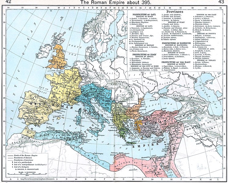
Deutsch: Das römische Reich zum Zeitpunkt des Todes Theodosius' I. 395 n. Chr. |
| 日期 | |
| 来源 |
|
| 作者 | Shepherd, William R. |
_en.png)
.png)
.jpg)
许可协议
[编辑]
|
本作品在其来源国以及其他著作权期限是作者逝世后70年或以下的国家和地区属于公有领域。 | |
| 本文件已被确认为免除已知的著作权法限制(包括所有相关权利)。 | |
文件历史
点击某个日期/时间查看对应时刻的文件。
| 日期/时间 | 缩略图 | 大小 | 用户 | 备注 | |
|---|---|---|---|---|---|
| 当前 | 2022年11月29日 (二) 21:07 | | 2,316 × 1,861(1.87 MB) | Gyalu22(留言 | 贡献) | more light |
| 2005年10月31日 (一) 13:51 |  | 2,316 × 1,861(808 KB) | Saperaud~commonswiki(留言 | 贡献) | Technisch überarbeitet von wolpertinger 14:49, 6. Apr 2005 (CEST) - Originalbild siehe Versionsgeschichte | |
| 2005年10月31日 (一) 13:43 |  | 2,316 × 1,861(826 KB) | Saperaud~commonswiki(留言 | 贡献) | *'''Description:''' Das römische Reich zum Zeitpunkt des Todes Theodosius' I. 395 n. Chr. <b>Quelle:</b> Shepherd, William R.: ''Historical Atlas.'' New York: Henry Holt and Company, 1923. Technisch überarbeitet von [[Benutzer:Wolpertinger|wolpertinge |
您不可以覆盖此文件。
文件用途
以下37个页面使用本文件:
- Atlas of Albania
- Atlas of Algeria
- Atlas of Austria
- Atlas of Bosnia and Herzegovina
- Atlas of Croatia
- Atlas of Cyprus
- Atlas of Egypt
- Atlas of European history
- Atlas of Galicia
- Atlas of Greece
- Atlas of Hungary
- Atlas of Israel
- Atlas of Jordan
- Atlas of Kosovo
- Atlas of Lebanon
- Atlas of Libya
- Atlas of Luxembourg
- Atlas of Malta
- Atlas of Montenegro
- Atlas of Morocco
- Atlas of North Macedonia
- Atlas of Northern Cyprus
- Atlas of Palestine
- Atlas of Portugal
- Atlas of Republika Srpska
- Atlas of Serbia
- Atlas of Slovenia
- Atlas of Spain
- Atlas of Syria
- Atlas of Tunisia
- Atlas of Turkey
- Atlas of Vojvodina
- Atlas of ancient Rome
- Atlas of the Byzantine Empire
- Atlas of the Middle Ages
- Illyria and Illyrians
- Maps of Switzerland
全域文件用途
以下其他wiki使用此文件:
- af.wikipedia.org上的用途
- ar.wikipedia.org上的用途
- ast.wikipedia.org上的用途
- azb.wikipedia.org上的用途
- az.wikipedia.org上的用途
- ba.wikipedia.org上的用途
- bg.wikipedia.org上的用途
- bs.wikipedia.org上的用途
- ca.wikipedia.org上的用途
- cs.wikipedia.org上的用途
- cv.wikipedia.org上的用途
- da.wikipedia.org上的用途
- de.wikipedia.org上的用途
- de.wikibooks.org上的用途
- en.wikipedia.org上的用途
- Theodosius I
- Theodosian dynasty
- Sack of Rome (410)
- Maritime history of Europe
- User:Jc37/Userboxes
- User:Jc37/Userboxes/User Roman Empire
- Talk:Byzantine Empire/Archive 2
- History of Roman-era Tunisia
- Traianopolis (Phrygia)
- Historiography in the Middle Ages
- User:Falcaorib/Ancient Empires (150-500 AD)
- User:Falcaorib/Europe
- es.wikipedia.org上的用途
- et.wikipedia.org上的用途
查看此文件的更多全域用途。