File:Roman provinces of Illyricum, Macedonia, Dacia, Moesia, Pannonia and Thracia.jpg
Bước tới điều hướng
Bước tới tìm kiếm

Kích thước hình xem trước: 740×600 điểm ảnh. Độ phân giải khác: 296×240 điểm ảnh | 592×480 điểm ảnh | 947×768 điểm ảnh | 1.263×1.024 điểm ảnh | 2.526×2.048 điểm ảnh | 2.817×2.284 điểm ảnh.
Tập tin gốc (2.817×2.284 điểm ảnh, kích thước tập tin: 1,41 MB, kiểu MIME: image/jpeg)
Chú thích
Chú thích
Ghi một dòng giải thích những gì có trong tập tin này
| Miêu tả |
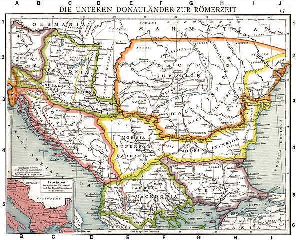
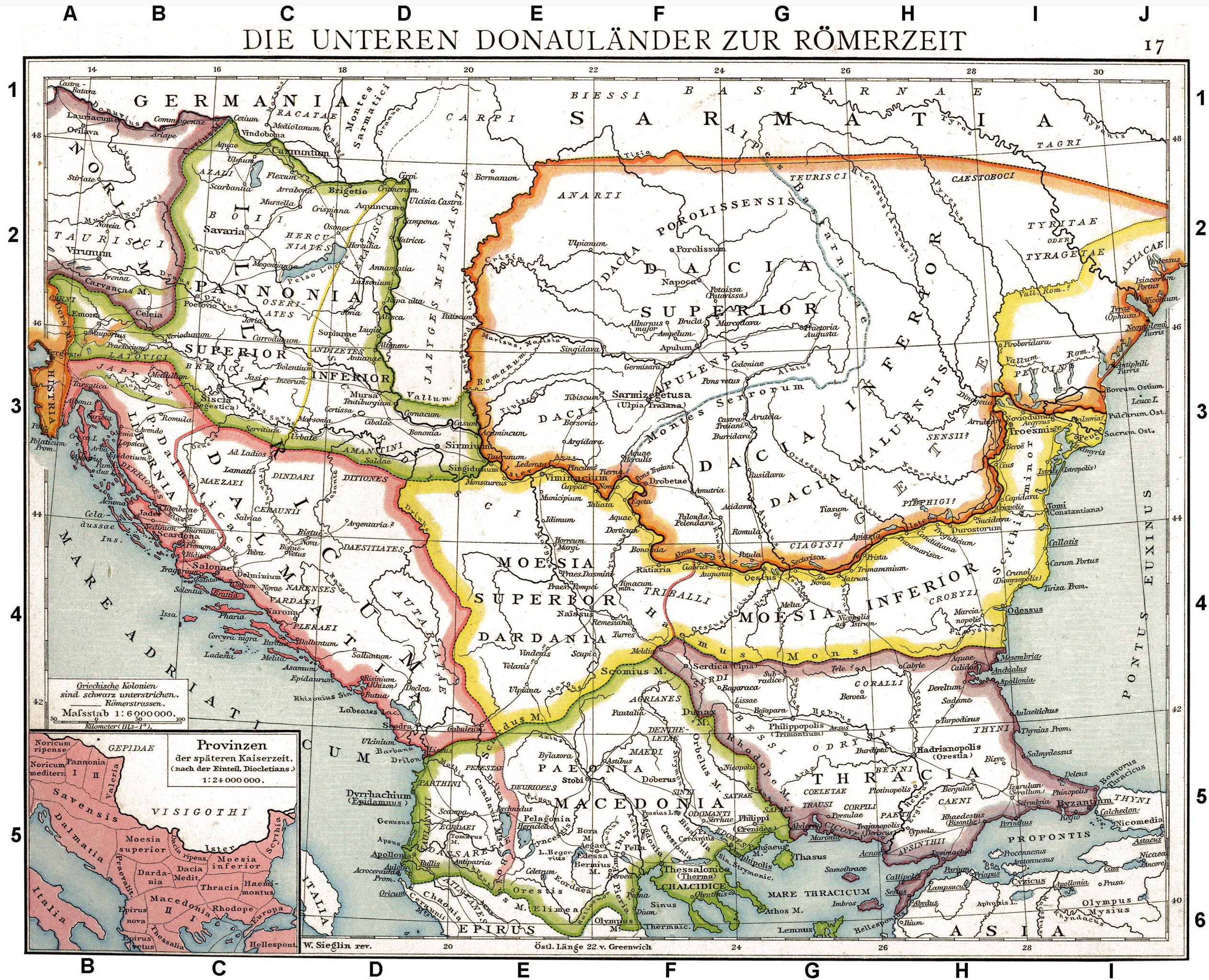
Deutsch: Die unteren Donauländer zur Römerzeit. Alte historische Karte aus Droysens Historischem Handatlas, 1886
English: The Roman provinces of the Lower Danube. Old historical map from Droysens Historical Atlas, 1886
Français : Provinces romaines d'Illyrie, de Macédoine, de Dacie, de Mésie, de Pannonie et de Thrace. Carte issue de l'Allgemeiner Historischer Handatlas de Gustav Droysen dirigé par Richard Andree, 1886. |
| Ngày | |
| Nguồn gốc | Allgemeiner historischer Handatlas in 96 Karten mit erläuterndem Text Bielefeld, Velhagen & Klasing 1886, S. 16. |
| Tác giả | Gustav Droysen (1838 — 1908) |
| Phiên bản khác |
Derivative works of this file: |
.jpg)
|
Tác phẩm này thuộc về phạm vi công cộng tại quốc gia gốc và các quốc gia và vùng lãnh thổ có thời hạn bản quyền là cuộc đời tác giả cộng thêm 100 trở xuống. | |
| Tập tin này đã được đánh dấu là không bị hạn chế dưới luật bản quyền, kể cả tất cả những quyền liên quan và lần cận. | |
Tác phẩm này thuộc về phạm vi công cộng ở Hoa Kỳ vì nó được phát hành trước ngày 1 tháng 1 năm 1929.
Tác phẩm thuộc phạm vi công cộng phải hết hạn bản quyền ở cả Hoa Kỳ lẫn quốc gia gốc của tác phẩm thì mới có thể lưu trữ tại Commons. Nếu tác phẩm không phải của Hoa Kỳ, tập tin phải có một thẻ bản quyền nữa để ghi rõ tình trạng bản quyền của quốc gia gốc.
|
| Annotations | This image is annotated: View the annotations at Commons |
Lịch sử tập tin
Nhấn vào ngày/giờ để xem nội dung tập tin tại thời điểm đó.
| Ngày/Giờ | Hình xem trước | Kích cỡ | Thành viên | Miêu tả | |
|---|---|---|---|---|---|
| hiện tại | 10:06, ngày 11 tháng 9 năm 2010 | | 2.817×2.284 (1,41 MB) | DIREKTOR (thảo luận | đóng góp) | Repairs |
| 19:22, ngày 27 tháng 5 năm 2008 |  | 2.817×2.284 (1,75 MB) | File Upload Bot (Magnus Manske) (thảo luận | đóng góp) | {{BotMoveToCommons|en.wikipedia}} {{Information |Description={{en|Illyricum the Roman Province}} |Source=Transferred from [http://en.wikipedia.org en.wikipedia]; transfered to Commons by User:Koryakov Yuri using [http://tools.wikimedia.de/~magnus/com |
Bạn không được phép ghi đè tập tin này.
Trang sử dụng tập tin
22 trang sau sử dụng tập tin này:
- American Romanian Academy of Arts and Sciences
- Ancient Thrace and ancient Thracians
- Atlas of Albania
- Atlas of Croatia
- Atlas of European history
- Atlas of Vojvodina
- Atlas of the antiquity
- Dacia and Dacians
- Illyria and Illyrians
- Snake Island (Black Sea)
- User:Linguae
- File:Illyricum.jpg (tập tin đổi hướng)
- File:Late roman province Thracia Outcut from Roman provinces of Illyricum, Macedonia, Dacia, Moesia, Pannonia and Thracia.jpg
- File:ROM 1976 MiNr3358 pm B002.jpg
- File:RomanDardaniaMoesiaSuperior1.png
- File:Roman Dardania (detail), Droysens Historical Atlas, 1886.jpg
- File:Roman Provinces During Diocletian's rule Epirus Nova or Illyria Graeca.jpg
- File:Roman province of Macedonia.jpg
- File:Roman provinces of Illyricum, Macedonia, Moesia, Pannonia and Thracia.jpg (tập tin đổi hướng)
- File:Roman provinces of Macedonia (western region).jpg
- File:Thracia Outcut from Roman provinces of Illyricum, Macedonia, Dacia, Moesia, Pannonia and Thracia.jpg
- Category:Roman Dalmatia
,_Droysens_Historical_Atlas,_1886.jpg)
Sử dụng tập tin toàn cục
Những wiki sau đang sử dụng tập tin này:
- Trang sử dụng tại als.wikipedia.org
- Trang sử dụng tại an.wikipedia.org
- Trang sử dụng tại ar.wikipedia.org
- Trang sử dụng tại arz.wikipedia.org
- Trang sử dụng tại ast.wikipedia.org
- Trang sử dụng tại azb.wikipedia.org
- Trang sử dụng tại az.wikipedia.org
- Trang sử dụng tại be.wikipedia.org
- Trang sử dụng tại bg.wikipedia.org
- Trang sử dụng tại br.wikipedia.org
- Trang sử dụng tại bs.wikipedia.org
- Trang sử dụng tại ca.wikipedia.org
- Trang sử dụng tại da.wikipedia.org
- Trang sử dụng tại de.wikipedia.org
- Thrakien (Landschaft)
- Geschichte Kroatiens
- Geschichte Sloweniens
- Illyrien
- Geschichte Ungarns
- Dalmatia
- Moesia
- Geschichte von Bosnien und Herzegowina
- Arad (Rumänien)
- Diskussion:Pannonia (Provinz)
- Pannonischer Aufstand
- Benutzer:Devil m25/Spielwiese
- Donaulimes
- Balkanromanische Sprachen
- Moesia inferior
- Via Militaris (Balkan)
- Diskussion:Serben/Archiv
- Biosphärenreservat Donaudelta
- Geschichte der Stadt Perg
- Taurisker
- Machland
Xem thêm các trang toàn cục sử dụng tập tin này.
Đặc tính hình
Thể loại:
- Maps from Allgemeiner Historischer Handatlas
- Old maps of the Balkans
- Maps of the history of the ancient Balkans
- Maps of Roman Dalmatia
- Old maps of Dalmatia
- Maps of Noricum
- Maps of Roman Pannonia
- Maps of Roman Dacia
- Maps of Dacian tribes
- Maps of Illyricum
- Roman Macedonia
- Roman Thrace
- Moesia Superior
- Moesia Inferior
- Triballi
- Iazyges
- Maps of Paeonia
- 1886 maps of Europe