User:Goran tek-en/discussions/2022
 | This is an archive of past discussions. Do not edit the contents of this page. If you wish to start a new discussion or revive an old one, please do so on the current talk page. |
Discussions 2022
File:Map of Australia and New Zealand with an inset.svg
Example

Australia

Goran tek-en, that lake you got rid of is actually Canberra, the capital city of Australia. You need to change the blue border colour and make the border the same colour as the other state borders, thanks. Alextigers (talk) 18:34, 12 April 2022 (AEST)
- Alextigers I don't understand as there are no cities at all in that map. Regarding the state borders, Australia is one state to my knowledge. Be more correct and specific if you want me to change something, thanks. --please ping me-- Goran tek-en (talk) 12:33, 12 April 2022 (UTC)
- Apologies Goran tek-en, I was only trying to help. Australia has 6 states which are Queensland, New South Wales, Victoria, Tasmania, South Australia and Western Australia. The other two are Australian territories, which are Northern Territory and the Australian Capital Territory, which Canberra lies (capital city).
- Your first upload was correct but that lake is meant to be the Australian Capital Territory. It only needs the grey dotted border lines like the other states/territories. Alextigers (talk) 18:04, 13 April 2022 (AEST)
- Alextigers Thanks for the information and knowledge, I'm a graphic worker and has no knowledge of this.
- I need to do an update for this map (all over) based on your information, thanks.
- I will be back with a draft I hope you can check for me. --please ping me-- Goran tek-en (talk) 14:52, 13 April 2022 (UTC)
- Alextigers Thanks for the information and knowledge, I'm a graphic worker and has no knowledge of this.
- Your first upload was correct but that lake is meant to be the Australian Capital Territory. It only needs the grey dotted border lines like the other states/territories. Alextigers (talk) 18:04, 13 April 2022 (AEST)
- No worries, take your time. Your map is great because the only Australia and New Zealand map that was on Wikimedia Commons was the grey map. I’m using your map for Australia's top tier basketball league (NBL). NBL are considering bringing back the Canberra Cannons, based in the Australian Capital Territory, possibly in 2023 or 2024. Alextigers (talk) 10:30, 15 April 2022 (AEST)
- Noticed your recent update. I forgot to show you the Australia map. The lake does go through the Australian Capital Territory. Alextigers (talk) 11:20, 23 April 2022 (AEST)
- Alextigers Which lake do you mean or did you mean river?
- Uploaded new version with edited lines, hope its better visibility. I'm working on another version for Australia states, territories. --please ping me-- Goran tek-en (talk) 12:49, 24 April 2022 (UTC)
- Alextigers New map, I'm not sure you or someone else has any need for it but I hope so, Australia states territories.
- Thanks for your knowledge, and if you ever need a map or illustration and you think I can help you just contact me, thanks.
 Done --please ping me-- Goran tek-en (talk) 13:39, 24 April 2022 (UTC)
- Alextigers New map, I'm not sure you or someone else has any need for it but I hope so, Australia states territories.
- Alextigers Which lake do you mean or did you mean river?
- Noticed your recent update. I forgot to show you the Australia map. The lake does go through the Australian Capital Territory. Alextigers (talk) 11:20, 23 April 2022 (AEST)
- Oh, I mean river not lake. Thanks for helping me because mapping isn’t my strongest area.
- Map you made is good for Australia and New Zealand. Hopefully the map gets added to location map~ setting. Not sure how it will get added but you may have a better idea then me. Location maps are good because you can adjust the size and add a caption below. Alextigers (talk) 00:07, 25 April 2022 (AEST)
- Alextigers To my understanding Location maps is just maps following the conventions set up for them, Conventions/Location_maps. Very often they also have geographic limits of the map in the infobox like here France location map.
- They are also added to special Categories for just location maps. Other from that they are just as any other map and adding a caption (I guess you mean in a wikipedia article) should be possible to any map to my knowledge. I don't know much about creating an article in wikipedia but a file is a file. Addjusting the size (do you mean thumbnail or other) should also be possible for any map/file. There is a difference between a bitmap (png, jpg etc) and a vector (svg) map/file. A svg file can be enlarged to any size without loosing any sharpness (other things will happen which will effect the image) but if you enlarge a bitmap bigger than what it's pixel size is, it will become blurry.
- If this doesn't help you you will have to be more specific and link me to show what you mean. --please ping me-- Goran tek-en (talk) 15:05, 24 April 2022 (UTC)
- Alextigers To my understanding Location maps is just maps following the conventions set up for them, Conventions/Location_maps. Very often they also have geographic limits of the map in the infobox like here France location map.
- Map you made is good for Australia and New Zealand. Hopefully the map gets added to location map~ setting. Not sure how it will get added but you may have a better idea then me. Location maps are good because you can adjust the size and add a caption below. Alextigers (talk) 00:07, 25 April 2022 (AEST)
Another Hundred Years' War map?
| Extended content |
|---|
|
You have been the go to map maker for the surge in activity in Hundred Years' War articles over the past three years. This has seen twenty articles achieve Featured Article status - 0.33% of all the Featured Articles on Wikipedia! This surge will shortly be coming to an end, but there are two of the more important articles on the period to go. The magnificent maps which grace these twenty Featured Articles include:
I am hoping that I might impose on you for one more masterpiece, which would be similar to the second of those above. I have had a request up in the usual place for a while, but it has attracted no takers, so please excuse this direct approach. Obviously if time or motivation means that you decline I entirely understand. Thanks. Gog the Mild (talk) 22:24, 22 December 2021 (UTC)
Thanks. Gog the Mild (talk) 18:51, 20 January 2022 (UTC)
Major cities:
Gog the Mild (talk) 16:20, 24 January 2022 (UTC) Links - my error, apologies; fixed. Gog the Mild (talk) 17:18, 24 January 2022 (UTC)
--please ping me-- Goran tek-en (talk) 15:19, 29 January 2022 (UTC)
|
Gog_the_Mild Now you can find it here file:Black Prince's campaign 1356.svg.
- I didn't understand if you wanted me to remove something. If anything needs to be edited just let me know.
- Structured data, yes it's really big and complicated, I have just started to understand a tiny bit of it. If you look in Description I have added some there and in the tab Structured data I have also added, please check.
- Please check all the information, also links for wikipedia, wikidata and structured data.
- Done --please ping me-- Goran tek-en (talk) 16:56, 6 February 2022 (UTC)
- Wonderful. Many thanks.
- I think that the word "Prince" against La Haye is unnecessary and could be removed. But if you feel that it is better to leave it, that is fine.
- Insofar as I understand them, the Structured data and Wikidata looks fine.
- Content checked; links checked.
- Thanks again.
- 86.131.179.195 20:56, 6 February 2022 (UTC)
- @Gog the Mild Prince removed. Done --please ping me-- Goran tek-en (talk) 17:29, 7 February 2022 (UTC)
- @Gog the Mild Prince removed.
Request: removing a halo
Hello! I have a request for you.
File:People together.svg is supposed to be the SVG version of File:Together.png. However, the SVG version has a white halo aroung the characters (it can easily be seen on a non-white background). Could you remove the halo from the SVG?
For your information, the corrected SVG should be used at w:Template:Close relationships. Veverve (talk) 20:09, 1 February 2022 (UTC)
- @Veverve Done --please ping me-- Goran tek-en (talk) 14:51, 2 February 2022 (UTC)
- @Goran tek-en: you have removed all white parts from the image, including those on the characters. I had only asked for the halo around the characters to be removed, see File:Together.png for a model of the result I ask. Veverve (talk) 17:25, 2 February 2022 (UTC)
- @Veverve Now then. --please ping me-- Goran tek-en (talk) 17:52, 2 February 2022 (UTC)
- @Goran tek-en: it looks very good now, thanks! Veverve (talk) 17:55, 2 February 2022 (UTC)
- @Veverve Now then. --please ping me-- Goran tek-en (talk) 17:52, 2 February 2022 (UTC)
- @Goran tek-en: you have removed all white parts from the image, including those on the characters. I had only asked for the halo around the characters to be removed, see File:Together.png for a model of the result I ask. Veverve (talk) 17:25, 2 February 2022 (UTC)
Request: WW2 Map(s)
@Goran tek-en: Hyello! It's me...again
I'd love it if you could convert some more West Point maps. I plan on helping to make more detailed operations maps, especially for this period. (Most are in Russian or French. West Point maps tend to be inaccurate.)
For Operation Bagration: https://www.westpoint.edu/sites/default/files/inline-images/academics/academic_departments/history/WWII%20Europe/WWIIEurope30.pdf
For the D-Day Landings: https://www.westpoint.edu/sites/default/files/inline-images/academics/academic_departments/history/WWII%20Europe/WWIIEurope55.pdf
One with the actual operations and one that's more like a "basemap". So, 4 maps? Sorry for disturbing you. TheStrandedDemon (talk) 21:16, 2 February 2022 (UTC)
| Extended content |
|---|
|
- @Goran tek-en
- I keep forgetting, I am extremely sorry for the major inconvenience. I've been occupied with so much writing recently.
- I will complete the cities you said were wrong, the rest will be posted throughout this week:
- - Polotsk: 55.483157, 28.799062
- - Rogachev: 53.0746, 30.0511
- - Fostov: 50.0638, 29.9050
- - Zhitomyr: 50.2547, 28.6587
- - Tarnopal: 49.5535, 25.5948
- - Lokhvitsa: 50.3589, 33.2590
- - Kirovo: 58.5541, 49.9886
- - Krivoli Rag: 47.9105, 33.3918
- - Kharkov: 49.9935, 36.2304
- - Izyum: 49.2121, 37.2665
- - Voroshilovgrad: 48.5740, 39.3078
- - Stalino: 48.0159, 37.8028
- TheStrandedDemon (talk) 12:51, 28 March 2022 (UTC)
- @TheStrandedDemon
- It's not my intention to push you, if you want to continue at a later time, please let me know.
- To me this was all of the cities but if you have more for the base map just send me.
- To me Kirovo: 58.5541, 49.9886 is outside our map area
- Check it all for the base map, but please remember that the final placing of names can't be made until we have everything in the map, also the visibility of texts can't be finished until than.
- Draft-2 --please ping me-- Goran tek-en (talk) 17:43, 28 March 2022 (UTC)
- @TheStrandedDemon It takes to much energy from me to keep pushing your request so I will wait until you have the time, just contact me then, thanks. --please ping me-- Goran tek-en (talk) 13:06, 1 April 2022 (UTC)
Yet another Hundred Years' map?
With the campaign leading up to it at FAC I am now working on the actual Battle of Poitiers. I was wondering if you might be able to assist me with a battle map or two? If so, the main one[s] would be based on this template. Fancy having a go? Thanks either way. Gog the Mild (talk) 20:27, 10 February 2022 (UTC)
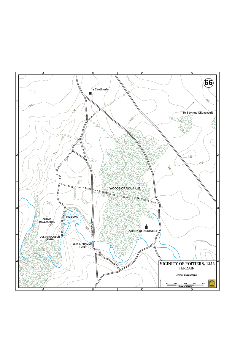
- @Gog the Mild I can but right now I'm working on other things. Ping me in a couple of weeks, thanks. --please ping me-- Goran tek-en (talk) 13:09, 11 February 2022 (UTC)
- @Gog the Mild So, now we can work on your map. Can you explain more what kind of map you want, which information etc.
- Can you provide me with link to original map or info if from a book and what copyright status it has. I have found the location, thanks. --please ping me-- Goran tek-en (talk) 12:45, 6 March 2022 (UTC)
New map request: Donbas
Long time no see! It's glad to see you're still churning out maps after all these years. I have a new, relatively simple request, if you've got some time. Presently, the English Wikipedia article on the Donbas region uses a relatively junk map that I made myself. I was hoping you could make me a new one. On this new map, I'd like to show the separation between Russian-held territory and Ukrainian-government held territory. A good model would be this map, though without including Belgorod or Berdyansk. I'd also like an additional map, the same map, without the Russian-held territory marked. Is this something that could be done? As far as map requests go, I think it should be pretty simple. Do let me know! RGloucester (talk) 15:54, 4 March 2022 (UTC)
| Extended content |
|---|
|
@RGloucester Now you can find it here file:Donbas (2015–2022).svg.
.svg)
- Please check all the information, also links for wikipedia, wikidata and structured data.
Now you can find it here file:Map of Donbas region.svg.
- Please check all the information, also links for wikipedia, wikidata and structured data.
![]() Done --please ping me-- Goran tek-en (talk) 19:13, 13 March 2022 (UTC)
Done --please ping me-- Goran tek-en (talk) 19:13, 13 March 2022 (UTC)
- Thank you so much Goran, as always. Keep well! RGloucester (talk) 19:51, 13 March 2022 (UTC)
Langues d'oïl Map Request
I like your map map of French dialects. The Wikimedia description should have a key for use on articles. For example, what are the red and blue areas? Is there a difference between the green and yellow shading? A simple key could allow writers to describe the image without making mistakes.
Also, consider labeling Paris with 'francien'. That dialect was one of the most important French languages and has evolved into standard French today. Thanks. Flameoguy (talk) 00:51, 6 July 2022 (UTC)
- @Flameoguy I'm a graphic worker and I made that svg map as a request from someone (I don't have any note of who) based on Départements+régions (France).svg and Langues d'oïl.PNG. As a graphic worker I don't have any knowledge regarding the content, that is normally the requester who has that.
- I would be happy to add the information/content you are talking about but I need someone who has the knowledge to tell me what is what and how words should be spelled.
- So if you have that knowledge/information, or you know how to get it, just let me know and we can improve this map together, thanks. --please ping me-- Goran tek-en (talk) 17:12, 6 July 2022 (UTC)
.svg)
Requesting a Wikipedia Logo
Greetings Goran! May you please consider making a localised Wikipedia logo for Tumbuka language Wikipedia. Unfortunately we don't have our own logo whilst most local wikis do have. The English words "WIKIPEDIA" in Tumbuka translates "WIKIPEDIYA" and the motto "The Free Encyclopedia" translates "Nkhokwe Yavinjelu Yaulele". . The Tumbuka Wikipedia is available at (tum.wikipedia.org). Thank you. Tumbuka Arch (talk) 15:33, 27 July 2022 (UTC)
- @Tumbuka Arch Hi, I can help you but please link me to the logo you want translated so it will be the correct one, thanks. --please ping me-- Goran tek-en (talk) 08:56, 29 July 2022 (UTC)
- Hello Goran,
- Thank you for a helping hand.The logo needed is similar to the one on English Wikipedia,the difference being the language in which the words are written.
- The English words "WIKIPEDIA" in Tumbuka translates "WIKIPEDIYA" (in capitals) and the motto "The Free Encyclopedia" translates "Nkhokwe Yavinjelu Yaulele" (with each first word capitalised).
- The logo that need to be translated is here, and also you might wanna see this.
- If there are other questions,please ask.
- Thank you. Tumbuka Arch (talk) 10:09, 29 July 2022 (UTC)
- @Tumbuka Arch There are guidelines that should be kept regarding those logos and here you can see how the different languages looks like (I will add yours once we are done).
- Drafts;
- The second row in "normal" font
- The second row as semi bold, I'm not really sure if this is OK (I think so) but it's more visible.
- Those png's are a bit blurry compared to what the svg which I will upload will be.
- Check those drafts and give me feedback, thanks. --please ping me-- Goran tek-en (talk) 19:06, 29 July 2022 (UTC)
- Hello @Goran tek-en
- I have checked them and they are marvelous and amazing!!
- Can you please upload the svg.
- Thank you. Tumbuka Arch (talk) 11:35, 5 August 2022 (UTC)
- The bold is amazing Tumbuka Arch (talk) 11:36, 5 August 2022 (UTC)
- @Goran tek-en i am just reminding you to upload the svg.
- Thanks. Tumbuka Arch (talk) 07:13, 6 August 2022 (UTC)
Tumbuka Arch
Now you can find it here Wikipedia-logo-v2-tum, ![]() Done --please ping me-- Goran tek-en (talk) 16:31, 6 August 2022 (UTC)
Done --please ping me-- Goran tek-en (talk) 16:31, 6 August 2022 (UTC)
- Hello @Goran tek-en
- Thank you so much and countlessly for the amazing work you have done! I dont take it for granted.You cant imagine how happy and excited i am right now.Thank you for helping my wiki.Thanks alot! Tumbuka Arch (talk) 17:40, 6 August 2022 (UTC)
File:Western sahara walls moroccan map-en.svg
This map claims to the rather accurate, but in fact it is just based on a sketch. In the past weeks, I have mapped the correct positions of the berms using Google Earth in KMZ files. Is it possible that you extract the KMZ files in order to update that map? Antemister (talk) 16:39, 7 August 2022 (UTC)
| Extended content |
|---|
1) it's complicated... keep it as a dotted line ("die hilflose internationale Standarddarstellung")
This time I was not so quick with my response... anyway. The map is done (except for the dotted part of the 4th wall, should be a line like the others, and the natural barrier goes till the algerian border (red)), now the legend is an issue. Describe the walls as (st, nd etc as superscript if possible), and without the wind rose)
So, a last issue regarding the image, can you expand the legend box? The spacing is rather small and above there is a lot of empty space, also the natural barriers and wadis entry should get a bigger line spacing. The superscript itself does not look as good as I expected, and if it causes problems you should remove it.--Antemister (talk) 11:54, 18 September 2022 (UTC)
No, keep it as it is. (the dashed line is a parallel wall, and in that case the "outer" one is relevant)--Antemister (talk) 20:05, 23 September 2022 (UTC)
Yes, finally done!--Antemister (talk) 16:20, 25 September 2022 (UTC) Antemister Now you can find it here file:Western sahara moroccan walls topographic map-en.svg.
|
- File:Western sahara territorial control topographic map-en.svg, described as Evolution of territorial control of the Western Sahara, any description the same as the other.--Antemister (talk) 13:07, 1 October 2022 (UTC)
Antemister Uploaded file: Western sahara territorial control topographic map-en, ![]() Done --please ping me-- Goran tek-en (talk) 16:58, 1 October 2022 (UTC)
Done --please ping me-- Goran tek-en (talk) 16:58, 1 October 2022 (UTC)
- OK, three minor flaws persist:
- In the Moroccan territory, a part of the wall is pink not red.
- In the legend, there should be a "Territory enclosed by:" on the top, and the the "Area" removed from the line, otherwise it is not understandable for the uninformed reader.
- Territory controlled by Polisario, not Polisario held terittory
- It would also make sense to use the same color scheme for the walls in the other map.--Antemister (talk) 21:50, 1 October 2022 (UTC)
- @Antemister Updated.
- Regarding changing colors of wall file: one could argue for that but on the other hand the colors picked there work for many with color deficiencies and as it's another map which is focused on the walls I think they are more visible generally all together. I do understand your point if they will be presented next to each other but then I personally rather would change the colors of the territory file as your wish for the colors to intuitively be understood as a flow/development is hard for me to grasp. So it's much a personal thing I guess. --please ping me-- Goran tek-en (talk) 15:18, 2 October 2022 (UTC)
- Ah, Ok forgot that issue I am usually not aware of, so keep it as it is. After this is done now, is not possible to calculate the size area of the Polisario-held territory? There are up to now no exact figure.--Antemister (talk) 20:03, 2 October 2022 (UTC)
- @Antemister
- I have checked it by two different ways and none of them are EXACT.
- In Inkscape I have calculated the area and then used the relation from the scale stock (this is very coarse) there and that gave me 87 388 km2.
- In My Maps from Google I imported the kml/z and then I used the measuring tool there. I had to draw the measuring on top of the lines imported and I didn't do it by extremely small steps but fairly and that gave me 82 018 km2.
- So somewhere around there and I think My Maps is more accurate than Inkscape because of the scale stock. I also think this measuring tool exist in Google Earth also so you can do it yourself in either of those tools.
- Would be interesting to hear if this is about correct if you can find another size from somewhere else. --please ping me-- Goran tek-en (talk) 13:35, 4 October 2022 (UTC)
- Of the major Wikipedias, only the German one, de:Demokratische Arabische Republik Sahara mentions an area of about 89,000 km², a figure that is unsourced. That's the reason which I asked that, as there was no accurate map of the walls before, it was hardly possible that anyone calculated an exact figure, such a calculation is then a side product of that map. As there is is a large difference, this seems to be an issue for a GIS expert. Do you have a kml file that unifies all my splinters?--Antemister (talk) 17:39, 4 October 2022 (UTC)
- @Antemister I would trust the GMM much more, I corrected the area with the small part in the inner corner so now it's 82 373 km2. It's not hard to do a better measurement but I don't think there will be a so big difference, I have emailed you the file. --please ping me-- Goran tek-en (talk) 18:38, 4 October 2022 (UTC)
- @Antemister It was a mistake with adding the inner corner area so it should be 82 018 km2 as I first stated. --please ping me-- Goran tek-en (talk) 10:42, 5 October 2022 (UTC)
- The map regarding the wall is now finished, thanks! Don't know if your still interested, two more (rather simple maps) on that topic are to be done. Do you want to continue?--Antemister (talk) 21:57, 9 October 2022 (UTC)
- @Antemister I can do that, please start new topic here. --please ping me-- Goran tek-en (talk) 08:45, 10 October 2022 (UTC)
- The map regarding the wall is now finished, thanks! Don't know if your still interested, two more (rather simple maps) on that topic are to be done. Do you want to continue?--Antemister (talk) 21:57, 9 October 2022 (UTC)
- Of the major Wikipedias, only the German one, de:Demokratische Arabische Republik Sahara mentions an area of about 89,000 km², a figure that is unsourced. That's the reason which I asked that, as there was no accurate map of the walls before, it was hardly possible that anyone calculated an exact figure, such a calculation is then a side product of that map. As there is is a large difference, this seems to be an issue for a GIS expert. Do you have a kml file that unifies all my splinters?--Antemister (talk) 17:39, 4 October 2022 (UTC)
- Ah, Ok forgot that issue I am usually not aware of, so keep it as it is. After this is done now, is not possible to calculate the size area of the Polisario-held territory? There are up to now no exact figure.--Antemister (talk) 20:03, 2 October 2022 (UTC)
Western Sahara 1976-1981
In 1976, Western Sahara got independent from Spain and was immediately divided between Morocco and Mauritania, the en:Western Sahara partition agreement, which also includes a map. What the map does not include is the area controlled by the Polisario, for that I have sent you a snippet from the German de:Tübinger Atlas des Vorderen Orients. In August 1979 Mauritania withdrew, Polisario occupied the Mauritanian part, and during the following months Morocco step by step withdrew its troops to the "useful triangle" as shown here[3], which the area that then the area enclosed by the first wall. File names are then File:Western sahara territorial control 1976-1979 topographic map-en.svg and File:Western sahara territorial control 1979-1981 topographic map-en.svg, regarding the 1979-1981 map, mark only the moroccon-controlled area and leave the other area blanc, an expert on the topic told me that the Polisario hardly created infrastructure or "facts on the ground" at that time.--Antemister (talk) 18:02, 10 October 2022 (UTC)
- @Antemister As (almost) always I have questions.
- I need the source for the snippet you sent me, can't be the whole German page.
- 76-79, Is it the blue boxed part you want added to what the map on the English page, but based on the map we recently created, with or without walls?
- 79-81, Base map as 76-79? The area is more like wall 1 and almost all of wall 2 to me, should I follow the map at page 4 or the walls?
- --please ping me-- Goran tek-en (talk) 13:58, 11 October 2022 (UTC)
- 1) Image sent
- 2) Yes the blue area, added to the recently created relief map. The map should also include the demarcation line between Morocco and Mauritania, as shown on the linked page
- 3) The map on the PDF, the walls were later built to enclose/secure the area already under Moroccan control. Also here Relief map.
- The colored area should fade, similar to the map of the Congo wars I linked above, as these are no fixed boundaries.--Antemister (talk) 16:50, 11 October 2022 (UTC)
- @Antemister You misunderstood me about the image, we have to state the sources here so I need to know where that image is from, link, book, page whatever. --please ping me-- Goran tek-en (talk) 12:12, 13 October 2022 (UTC)
- @Antemister Draft 76-79-1 --please ping me-- Goran tek-en (talk) 15:14, 13 October 2022 (UTC)
- @Antemister You misunderstood me about the image, we have to state the sources here so I need to know where that image is from, link, book, page whatever. --please ping me-- Goran tek-en (talk) 12:12, 13 October 2022 (UTC)
Proper cataloging of the TAVO is rather difficult, use this:
- Tübinger Atlas des Vorderen Orients. Reichert, Wiesbaden 1976-1994, Karte B X 11.2.
Regarding the map, there needs to be a distinction concerning the "control". The neither Morocco nor Mauritania had real "control" over the marked area, they only annexed and established bases in major settlements. So, these areas should be hatched, and a boundary line in between, and the legend says Territory annexed by Morocco/Mauritania. The area under Polisario control is then on top so that the hatches remain visible.--Antemister (talk) 18:37, 13 October 2022 (UTC)
- @Antemister 76-79-2 --please ping me-- Goran tek-en (talk) 14:03, 14 October 2022 (UTC)
- OK, once again something that could be misunderstood, of course the Moroccan and Mauritanian area need distinct colors (red for Morocco, green for Mauritania, like their flags). And the Polisario area should fade out, it has no fixed borders.--Antemister (talk) 21:23, 14 October 2022 (UTC)
- @Antemister But you wrote "Territory annexed by Morocco/Mauritania" should be written in the legend and to me that means they should be one unit, but I will change again. --please ping me-- Goran tek-en (talk) 11:42, 15 October 2022 (UTC)
- @Antemister 76-79-3 --please ping me-- Goran tek-en (talk) 12:06, 15 October 2022 (UTC)
- Now it's fine, only one issue write "Partition of Western Sahara, January 1976 - August 1979" into the legend. (Yes, I wrote that but the meaning was that you should only replace "control" by annexed in both entries).--Antemister (talk) 15:13, 15 October 2022 (UTC)
- @Antemister 76-79-4
- If this is fine now I will need the following;
- Name of the file: Western sahara territorial control 1976-1979 topographic map-en.svg
- Description (/language)
- Captions/s (/language)
- Category/ies at commons
- Structured data/Items portrayed in this file, the Q#, to be able to upload it at commons, thanks.
- --please ping me-- Goran tek-en (talk) 13:46, 16 October 2022 (UTC)
- Map depicting the territorial claims in the Western Sahara 1976-1979 and the area under Polisario control
- Category:SVG maps of Western Sahara, Category:Maps of the history of Western Sahara
- {{Institution |wikidata=Q6250}}
- --Antemister (talk) 21:01, 16 October 2022 (UTC)
- @Antemister Now you can find it here file:Western sahara territorial control 1976-1979 topographic map-en.svg.
- Please check all the information, also links for wikipedia, wikidata and structured data.
- --please ping me-- Goran tek-en (talk) 13:42, 17 October 2022 (UTC)
- @Antemister Draft 79-81-1 --please ping me-- Goran tek-en (talk) 14:11, 17 October 2022 (UTC)
- This time it is not about an annexation (Morocco had annexed the whole of Western Sahara in August 1979), but of territorial control, so depict the red area in the same style as Polisario territory in the previous map. The legend is "Territorial control in the Western Sahara, late 1979 - May 1981", the red area is described as "Area under Moroccon control (approximate)". Because Dakhla was also controlled by Morocco, the peninsula should also be red. As the map is still somewhat empty, I think it would make since to depict also the "useful triangle", i. e. the triangle Laayoune-Samara-Boucraa via a dashed line.--Antemister (talk) 19:41, 17 October 2022 (UTC)
- @Antemister Draft 79-81-2. --please ping me-- Goran tek-en (talk) 14:11, 18 October 2022 (UTC)
- No, displaying the useful triangle is not a good idea here (maybe an extra map for that, but there is currently no article about it). Upload the map without the triangle, description is "Map depicting the area under Moroccon control in the Western Sahara, late 1979 to May 1981, source is
- Director of Central Intelligence: Western Sahara. Ramifications of Mauritanian Withdrawal and Moroccan Expansion (= Interagency Intelligence Memorandum. 79-10018). Central Intelligence Agency, August 1979 (PDF; 0,5 MB).
- --Antemister (talk) 17:00, 18 October 2022 (UTC)
- @Antemister Now you can find it here file:Western sahara territorial control 1979-1981 topographic map-en.svg.
- Please check all the information, also links for wikipedia, wikidata and structured data.
- Done
- --please ping me-- Goran tek-en (talk) 12:54, 19 October 2022 (UTC)
- @Antemister Now you can find it here file:Western sahara territorial control 1979-1981 topographic map-en.svg.
- No, displaying the useful triangle is not a good idea here (maybe an extra map for that, but there is currently no article about it). Upload the map without the triangle, description is "Map depicting the area under Moroccon control in the Western Sahara, late 1979 to May 1981, source is
- @Antemister Draft 79-81-2. --please ping me-- Goran tek-en (talk) 14:11, 18 October 2022 (UTC)
- This time it is not about an annexation (Morocco had annexed the whole of Western Sahara in August 1979), but of territorial control, so depict the red area in the same style as Polisario territory in the previous map. The legend is "Territorial control in the Western Sahara, late 1979 - May 1981", the red area is described as "Area under Moroccon control (approximate)". Because Dakhla was also controlled by Morocco, the peninsula should also be red. As the map is still somewhat empty, I think it would make since to depict also the "useful triangle", i. e. the triangle Laayoune-Samara-Boucraa via a dashed line.--Antemister (talk) 19:41, 17 October 2022 (UTC)
- Now it's fine, only one issue write "Partition of Western Sahara, January 1976 - August 1979" into the legend. (Yes, I wrote that but the meaning was that you should only replace "control" by annexed in both entries).--Antemister (talk) 15:13, 15 October 2022 (UTC)
- @Antemister 76-79-3 --please ping me-- Goran tek-en (talk) 12:06, 15 October 2022 (UTC)
- @Antemister But you wrote "Territory annexed by Morocco/Mauritania" should be written in the legend and to me that means they should be one unit, but I will change again. --please ping me-- Goran tek-en (talk) 11:42, 15 October 2022 (UTC)
- OK, once again something that could be misunderstood, of course the Moroccan and Mauritanian area need distinct colors (red for Morocco, green for Mauritania, like their flags). And the Polisario area should fade out, it has no fixed borders.--Antemister (talk) 21:23, 14 October 2022 (UTC)
Done! Fine! Thanks! How did you draw the maps, QGIS?--Antemister (talk) 21:12, 19 October 2022 (UTC)
- @Antemister Inkscape, but I used QGIS to import-export the kmz to pdf and then Inkscape. --please ping me-- Goran tek-en (talk) 15:49, 20 October 2022 (UTC)
The background of the question was the following: The development of these maps was a small part (one of the few difficult) of large project, tracking of all border changes worldwide back to about 1870 (up to now , the chronology is done until 1937). The dataset has some 700 entries so far, of which about a fifth are border changes in a narrow sense, the remaining secessions, annexations and name changes requiring no graphical work (only source code changes). The chronology should someday transferred first into a GIS model, then to editable XML-based maps which in turn can form the base for historical maps in the Wikipedia and also elsewhere. It is likely that it too simply much (and too long-term) for a wikigraphist who is not deeply inside the matter. So I ask myself what to do with it? Learning QGIS on my own, an indian graphist... Is such a project feasible using a QGIS? How would you judge the time needed (per step)?--Antemister (talk) 05:43, 21 October 2022 (UTC)
- @Antemister Whow, that sounds like a big, long, never ending project.
- I,m personally not very knowledgeable in QGIS (or GIS generally), it has been an idea with me to learn more about QGIS but so far I haven't achieved this. I really would like to do this so I could do work from datasets and create maps that way but there is a knowledge threshold which is not negligible, so I don't know if I will actually do this. In Inkscape I do most of the work in WYSIWYG mode and just some corrections etc in code mode. So it's mainly manual work I do, not from datasets, but there are graphic workers here with that type of knowledge.
- From what you wrote above (to my understanding) this project seems like a typical datasets-GIS-automated workflow and that you need someone with much database, coding, automated GIS knowledge. If you are or can become this person is not for me to assess.
- For a project like this (once again, to my understanding) it will be extremely important that guidelines, "rules", structures etc is set up and followed. As there will be different people (and changing) involved in such a project at commons or other wikimedia part this will be even more important.
- Also it will be important to work in such a way that all the data, software, media exported etc from this project can adjust to the development of all included parts over time.
- With my experience from working with maps here at commons I also would like to point out that A MAP is very seldom a clean specific entity, there are so many parameters involved in A MAP that it's often extremely hard to compare or combine it with another map and make them work perfectly together. As I work, mainly manually, I do the adjustments, corrections manually so that the end product will work in that scale and with accuracy enough to be viewed in 100%. This means the maps are not 100% accurate or comparable to most other maps but for it's purpose they work. When you work with databases, sets, automated workflow it's a completely different thing. Everything that comes out of it is just exactly what you put in, there is no hand, eye, softening a line or adjusting something else, no logical check if it seems fine.
- This has of course both its pros and cons and with a large amount of data, maps you just have to accept this, set it up as good as you can and be aware of pros and cons.
- German map place, which what I have heard is very good at creating maps, but of course there are more places and people with this typ of knowledge. --please ping me-- Goran tek-en (talk) 11:30, 21 October 2022 (UTC)
- Ah, it seems your at least interested in it, so I continue writing. The whole issue is not new, I started the project around a decade ago, together with a now inactive German graphist. A handful of test maps were created, see Template:Historic world map series (they are test maps, so they still have some flaws), but then the project fell asleep until I reactivated it during two quarantines last year. That is the background of the Western Sahara issue - that topic had to be done before restarting the world map project as there had been no detailed maps of these walls before.
- The original intention was to draw only low-scale worldmaps for using them as choropleth map. Of course a relevant project, thousands of such maps are used here. But in the meantime I realized that this scope is to narrow, for example maps or Europe are also needed. So I came to the idea that it should be done as a QGIS project rather than an Inkscape one, and done in a 1:1.000.000 scale (I guess the additional workload of drawing a border in 1:1.000.000 is low compared to doing the same in 1:50.000.000). The possible applications grow tremendously, it can be used as a base for locator maps of smaller countries, thematic maps and also for additional scientific purposes outside the Wikipedia. Since myself I don't have any GIS knowledge, I cannot judge even basic issues, i. e. if files from GIS and Inkscape can be interchanged easily, if it is possible to downscale high-scale to low-scale automatically, if XML-based maps can be drawn directly from QGIS, if you as a graphist can you boundaries that fit to others, if it is possible to edit a 1:1.000.000 world map in Inkscape alone etc...
- In addition, I had developed a small tool for these kind of maps. It extracts from the map a the list of countries to a table, then you assign a color to it and then save it (can send it to you if you want). When it comes to coding, I can do a lot on my own, but when it comes to graphical work, I have no skills, that's why I asked.--Antemister (talk) 13:55, 23 October 2022 (UTC)
- @Antemister This is so big (in my mind) that it's hard to imaging how just a handful of people can achieve this and it's an never ending project. It's admirable of you to start and work on this, really.
- It seems as you are talking about many thousands of maps but how many of them do you calculate will be used, how many is there needs for?
- What I think of is locator maps and how the German Kartenwerkstatt works with those. My German is not that good so I can't read a lot there easily but it seems like a typ of project/organisation you would need and I think you are from Germany, right.
- I'm mostly interested in a lot of things and to learn new things but I'm also not very good in doing more or less the same thing for a longer time e.g. routine work, I get bored.
- So depending of what you think I might or might not be interested in such a project but at this time I'm not interested to set it up and run it or part of it, it seems to big and a never ending thing, I think I would let you down on the path. --please ping me-- Goran tek-en (talk) 15:18, 23 October 2022 (UTC)
- Yes, I have asked the German graphic lab once, but the reply the same: valuable project, but too large and too long-term, would block a graphist for too long. That's obvious, also clear for me, but I have tried again... How many of these maps will be used? Only a few, for some specific years (1938, 1949, 1960, 1975, 1989 for example), and this is to the point. My first idea was, let's create a handful maps for some important years, a manageable workload. But when I started the research, it came out, this is not possible if it you want to have correct boundaries. Such a series has to be created step by step, inflating the amount of work. So it's current status, stuck (regarding the graphic work, of course).
- Anyway, I'll see what I'll do. So many hours of work went into the project and there is only the list which is itself valuable but I don't have anything "visual" up to now.
- But would you be able to do some cleanup of one of the maps I linked so I can rollout my tool?
- --Antemister (talk) 18:55, 23 October 2022 (UTC)
- @Antemister So knowing about the enormously of this, what did you really think I as one person could do?
- I haven't really understood the list, tool as to my understanding this was supposed to be run by DB, coding and GIS, so what did you think a hands on graphist could do for you.
- But if you think I (as being the type of graphist I am) can help you with some maps I will try to help you with that, but please remember: not for the total project.
- So start a "request" somewhere which is fine with you and explain to me what I need to know and I will try to help you. --please ping me-- Goran tek-en (talk) 09:55, 24 October 2022 (UTC)
- No worry, I did not expect a "yes" ;-) I just ask from time to time random people...
- There are currently two other "difficult" ones (South Arabia and Caucasus, both in final stages of data collection), expected to be ready the next few months, and the mentioned base map. I'll come back to you then.--Antemister (talk) 21:55, 26 October 2022 (UTC)
- Ah, it seems your at least interested in it, so I continue writing. The whole issue is not new, I started the project around a decade ago, together with a now inactive German graphist. A handful of test maps were created, see Template:Historic world map series (they are test maps, so they still have some flaws), but then the project fell asleep until I reactivated it during two quarantines last year. That is the background of the Western Sahara issue - that topic had to be done before restarting the world map project as there had been no detailed maps of these walls before.
Lesotho Map Requests
Hiǃ Would you be interested in creating historical maps of pre-colonial Lesotho? The copyrighted maps are scattered in different books accessible on archive.org, you need a free account to view them. If you are up for it I will drop you the links. Thanks in advance. Catlemur (talk) 18:06, 15 November 2022 (UTC)
- @Catlemur I can do that if you will be here to help me in the work?
- I don't know yet if I'm willing to open an account there, will see, if not you would have to provide me with screen prints. If the material is copyrighted we can only use it as information and not "copy" it. So get back to me with the material and sources that I need and what type of map you would like, thanks. --please ping me-- Goran tek-en (talk) 19:24, 15 November 2022 (UTC)
ː̻@Goran tek-en: I screenshotted the maps and uploaded them to imgurː Lesotho after the Treaty of Thaba Bosiu (1866). If the screenshots are not good enough you can see the original pages hereː Becker and Thompson. I am not sure about the copyright status of the maps but I assume they are copyrighted.--Catlemur (talk) 20:30, 15 November 2022 (UTC)
- @Catlemur I'm a graphic worker and I do graphic work. It's up to you as the requester to search and find the sources and to check the copyright statues. It's just impossible for me to do that with all the different subjects and sources the different requestors provide. But for that site check [4] and [5] and then let me know. --please ping me-- Goran tek-en (talk) 21:08, 15 November 2022 (UTC)
ː̻@Goran tek-en: I asked around and there is no copyright issue, since you will merely be drawing factual information from the maps instead of copying them stylistically.--Catlemur (talk) 10:59, 16 November 2022 (UTC)
- @Catlemur Always remember that I have zero knowledge of this subject so will have to be specific in what you want.
- First we have to decide on which overall area the map should cover. Lesotho on OSM and could you draw a rectangle on this screen print and show me.
- What is it you want depicted on the map?
- --please ping me-- Goran tek-en (talk) 11:22, 16 November 2022 (UTC)
- @Catlemur: I don't want to rush you but I need your help as above to be able to continue with your request, thanks. --please ping me-- Goran tek-en (talk) 12:05, 19 November 2022 (UTC)
ː̻@Goran tek-en: I am sorry, I just started a new job and I am much shorter on free time now. I will message you again when/if everything is ready.--Catlemur (talk) 17:00, 19 November 2022 (UTC)
- @Catlemur Of course, we all have other things to do, get back to me when you have the time, thanks. --please ping me-- Goran tek-en (talk) 17:40, 19 November 2022 (UTC)
Thank you for your contributions to Nguyễn Dynasty topics
.svg)
|
Great Southern Barnstar | |
| I just realised that I forgot to thank you for the tremendous work with that Bảo Đại period map of the Nguyễn Dynasty, especially since you were working with topics that you weren't familiar with. Whenever I see that map I just think of the thousands of people who will see your work without ever knowing who made it, but I know, and I'm grateful that you did. |
.svg)
- @Donald Trung Thanks for that but it's almost always like that. I don't have any deeper knowledge about the topics I'm creating maps or illustrations for so I'm always very dependent on the requestors knowledge, like yourself so thanks for your knowledge. Those maps can only be created in cooperation which the world would need a little bit more of, unfortunately. --please ping me-- Goran tek-en (talk) 11:01, 16 November 2022 (UTC)
- Then you're very talented as I could have never guessed that based on the amazingly detailed works that you produce in many fields. -- — Donald Trung 『徵國單』 (No Fake News 💬) (WikiProject Numismatics 💴) (Articles 📚) 12:16, 16 November 2022 (UTC)
Featured Picture Nomination

Hello. I just wanted to let you know that the image Arabic Varieties Map.svg, which was created or uploaded by you, has been nominated for featured picture status; have a look at the nomination page. Thank you and good luck! -- A455bcd9 (talk) 07:42, 20 November 2022 (UTC)
- A455bcd9 Thanks, I was actually thinking of this myself.
- I saw there was some changes done in the Description/Legend part at File:Arabic_Varieties_Map.svg which I think is strange/wrong.
- 31 This should be a solid color as the hatched part is explained in other place. If you keep this you will have to change/add for all the hatched, round patterns also, so it should be a solid color here.
- "Dotted area: speakers of this variety are widespread over the area" Should this not be "Dotted area: speakers of mixed varieties" --please ping me-- Goran tek-en (talk) 10:56, 20 November 2022 (UTC)
- Hi,
- 31: OK, fixed.
- For plain/striped/dotted: I need to find a better definition, I'll try to find something looking at the sources...
- A455bcd9 (talk) 12:10, 20 November 2022 (UTC)
- Here, Adam said: "6 and 9's overlap is done differently than any other overlap". I can't see the difference, is there one? A455bcd9 (talk) 12:28, 20 November 2022 (UTC)
- @A455bcd9
- 6-9, it might be because the light green makes it harder to see the dots (in 100%) so it's mistaken for lines. A solution is to try to find another color for the light green but it's tricky with consideration of color deficiency.
- 31 Yes the hatches are thinner and closer to be visible within each area, if we will use the original hatching we will have to do the inset I proposed before.
- --please ping me-- Goran tek-en (talk) 12:54, 20 November 2022 (UTC)
- OK, for me the current version is fine fine.
- Regarding the legend: I changed the definitions of solid, hatched, and dotted based on Ethnologue's guidelines for maps ("we typically use the convention of showing a language in an area if at least 25% of the population in that area speak the language fluently as an L1. However, a minority language may be shown on a map even if the speakers do not comprise more than 25% of the population in any given area. This exception is made when the minority language is indigenous to that area only or, when there is historical significance for the language in that region.") and for locations ("Languages that are widely dispersed in specific locations or which are used by nomadic groups, are identified as “Scattered.”"). Ethnologue uses the term "Dispersed" for Hassaniya in Senegal and Nubi in Uganda, and "scattered" for Ta’izzi-Adeni Spoken in Djibouti. OK for you? A455bcd9 (talk) 13:03, 20 November 2022 (UTC)
- @A455bcd9 This part with definitions is out of my knowlege as a graphic worker and is totally up to you. --please ping me-- Goran tek-en (talk) 13:26, 20 November 2022 (UTC)
- Hi, I've just added notes (not all of them): what do you think? is it useful? If yes => I'll add them all. If not => I'll remove them all. A455bcd9 (talk) 12:35, 21 November 2022 (UTC)
- @A455bcd9 What I know ImageNotes only work at commons and the page of the image Arabic Varieties Map but there they can be very useful. So if you like it it's fine with me, thanks. --please ping me-- Goran tek-en (talk) 14:23, 21 November 2022 (UTC)
- Hi, I've just added notes (not all of them): what do you think? is it useful? If yes => I'll add them all. If not => I'll remove them all. A455bcd9 (talk) 12:35, 21 November 2022 (UTC)
- @A455bcd9 This part with definitions is out of my knowlege as a graphic worker and is totally up to you. --please ping me-- Goran tek-en (talk) 13:26, 20 November 2022 (UTC)
- @A455bcd9
- Here, Adam said: "6 and 9's overlap is done differently than any other overlap". I can't see the difference, is there one? A455bcd9 (talk) 12:28, 20 November 2022 (UTC)
Updating two timelines to 2022
Hello. The en:Macedonian Orthodox Church – Archdiocese of Ohrid has been recognised as a legitimate church in June this year.
Since the end of the year is nearing and I do not think any more change will happen in E. Orthodoxy, I think it is time to update two timelines for this major event: File:Timeline of the History of the main autocephalous Eastern Orthodox Churches, E. Orthodox point of view (2021).svg, and File:Timeline of the main schisms from the Serbian Orthodox Church (second quarter of the 19th century to 2021).svg. Thereafter, the files will need to be renamed to state that they go until 2022 and not 2021.
.svg)
.svg)
This change is only about changing one line, so it should be easy and quick.
What do you say? Do you have the time to perform those changes? Veverve (talk) 17:42, 26 November 2022 (UTC)
- @Veverve Sure I can do that. Regarding the names, do you need the year in the name, is it not enough in the Description? --please ping me-- Goran tek-en (talk) 18:06, 26 November 2022 (UTC)
- Thanks!
- Yes, I will need the name in the file title. You will have to overwrite the current files, then ask for them to be renamed.
- I will do the drafts right now. Veverve (talk) 18:11, 26 November 2022 (UTC)
- Text:
- "1967"
- "Macedonian Orthodox Church"
- "16 May 2022"
- "24 May 2022"
- "June 2022"
- "Autocephaly recognised by the Ecumenical Patriarchate"
- On both maps, please change "Macedonian Orthodox Church – Ohrid Archbishopric" to "Macedonian Orthodox Church".
- Drafts:
- https://imgur.com/a/n8tL3Uy
- https://imgur.com/a/poFaK2y ("1967" is already here, no need to add it)
- Text:
- Veverve (talk) 19:00, 26 November 2022 (UTC)
- @Veverve Check everything because I have changed old things also.
- --please ping me-- Goran tek-en (talk) 19:07, 27 November 2022 (UTC)
- Draft 1
- Remove "(UOC-KP)"
- Change "UOC-KP" by "Ukrainian Orthodox Church - Kyiv Patriarchate"
- My draft (I have indicated the part which should be removed with / / / /): https://imgur.com/a/nDkYHtr
- Draft 2
- It is good.
- Draft 1
- Veverve (talk) 19:25, 27 November 2022 (UTC)
- @Veverve Draft 1-2. --please ping me-- Goran tek-en (talk) 16:07, 28 November 2022 (UTC)
- Could you move the following dates, beginning of lines and legends, to a few pixels to the right?
- I have put a grey square and grey circles around those things that I asked to be moved, so that it is easier for you to find them: https://imgur.com/a/lqq3jld . Veverve (talk) 17:15, 28 November 2022 (UTC)
- @Veverve Draft 1-3 --please ping me-- Goran tek-en (talk) 17:56, 28 November 2022 (UTC)
- Change "Ukrainian Orthodox Church - Kyiv Patriarchate" to "Ukrainian Orthodox Church – Kyiv Patriarchate"
- I have noticed some buggy lines. I have also noticed some buggy lines inside or outside some donuts. Here they are: https://imgur.com/a/TYhvomG
- Veverve (talk) 18:14, 28 November 2022 (UTC)
- @Veverve Draft 1-4
- The buggy lines was my mistake, I forgot to switch of a support layer I use, you have great eyes. --please ping me-- Goran tek-en (talk) 18:28, 28 November 2022 (UTC)
- Here: the names should be moved to the right; it must be changed to this
- Here: the line is not linked with the donut.
- Here: the lines and the orange cross are not linked
- The following lines are not aligned with the donuts the way it is for the other donuts: https://imgur.com/a/ZQPDgBf
- Here: please change "Ukrainian Orthodox Church - Kyiv Patriarchate" to "Ukrainian Orthodox Church – Kyiv Patriarchate"
- Here: the green line exceeds the lenght
- Here: the two dates must be at the same height, and closer to each other
- Veverve (talk) 19:03, 28 November 2022 (UTC)
- @Veverve Draft 1-3 --please ping me-- Goran tek-en (talk) 17:56, 28 November 2022 (UTC)
- @Veverve Draft 1-2. --please ping me-- Goran tek-en (talk) 16:07, 28 November 2022 (UTC)
Veverve I unconsciously moved some lines which created many of the things you mentioned above, sorry for that.
I have now checked the whole timeline and compared to the others we have made so I hope I corrected them now.
- To me the two dates are lined up and if I move them any closer it will be hard to distinguish them from each other.
- Draft 1-5. --please ping me-- Goran tek-en (talk) 14:53, 29 November 2022 (UTC)
- Change "Serbian Orthodox Church (Patriarchate)", to "Serbian Orthodox Church (Patriarchate)"
- Change "Bulgarian Orthodox Church (Patriarchate) (seat in Preslav until the 970s, seat in Ohrid since then)", to "Bulgarian Orthodox Church (Patriarchate) (seat in Preslav until the 970s, seat in Ohrid since that time)"
- Change "Bulgarian Orthodox Church (Patriarchate) (seat in Sofia)", to "Bulgarian Orthodox Church (Patriarchate) (seat in Sofia)"
- Veverve (talk) 15:20, 29 November 2022 (UTC)
- @Veverve Draft 1-6 --please ping me-- Goran tek-en (talk) 18:14, 29 November 2022 (UTC)
- This is good! You can now upload those two timelines to replace the current files.
- Then, please ask for the files to be renamed:
- "File:Timeline of the History of the main autocephalous Eastern Orthodox Churches, E. Orthodox point of view (2021).svg", to "File:Timeline of the History of the main autocephalous Eastern Orthodox Churches, E. Orthodox point of view (2022).svg"
- "File:Timeline of the main schisms from the Serbian Orthodox Church (second quarter of the 19th century to 2021).svg", to "File:Timeline of the main schisms from the Serbian Orthodox Church (second quarter of the 19th century to 2022).svg"
- Veverve (talk) 18:28, 29 November 2022 (UTC)
- @Veverve Updated, you can ask for the renaming yourself, you know how to motivate it I don't, thanks. Done --please ping me-- Goran tek-en (talk) 10:27, 30 November 2022 (UTC)
- @Veverve Updated, you can ask for the renaming yourself, you know how to motivate it I don't, thanks.
- @Veverve Draft 1-6 --please ping me-- Goran tek-en (talk) 18:14, 29 November 2022 (UTC)
SVG 101
Hi @Goran tek-en!
I'd like to learn how to create SVG maps based on non-SVG maps available online. I've already done these two: Malurus cyaneus IUCN 2016.svg & Malurus splendens IUCN 2016.svg but they were fairly simple.
Now I'd like to do more complex ones such as:
What would you recommend? On the IUCN Red List website you can download "Range data - Polygons (SHP)" (shapefile) but I don't know how to open that file.
For Hadrami Arabic, I could just use your map, remove all other dialects and crop around the region I guess?
For Occitan dialects, is there a better way than just taking a free SVG background map of France and then adding a screenshot of that map on top of it (or this image) in transparency and manually draw lines on top of it and then fill the areas?
Do you have advice? Or a simple "how to" guide?
Best, A455bcd9 (talk) 20:00, 18 December 2022 (UTC)
- @[[User:A455bcd9|A455bcd9] For now (I have the flu) I will just give you a shorter answer.
- What I say here and otherwise is how I think about this subject, ask someone else and you will get a different answer.
- There is no quick "how to" for this, it's a complex and never ending educational tripp you are embarking on.
- There are so so many aspects and different parts of map making, creating illustrations, diagrams etc it's not just about drawing lines and coloring areas, that's the least part.
- If you think I can help you on this trip I would be more than happy to do so. But it's impossible for me to just write down some short things that would really help you, it would be a couple of books.
- You have reached out to me so I have to assume that you think I have some knowledge, experience that could help you, if so, I'm willing to share this with you.
- But as I wrote above, I can't just write everything down, this has to be a two person agreement on working on this together in many different ways:
- text
- sending material
- sharing screens
- talking
- for a longer time
- etc etc
- You might think that I'm taking this to seriously and sure, I could have sent you some links and forgot about it but that's not me.
- So if you can agree on what I write here I would be more than happy help you out, but it would have to be something like this that we agree on, get back to me, thanks. --please ping me-- Goran tek-en (talk) 15:19, 19 December 2022 (UTC)
- Hi @Goran tek-en: oh, get well soon!
- Yes I assume it's a long journey to become as good as you. I'd be more than happy to learn the ropes with you if you have some time.
- Best, A455bcd9 (talk) 15:22, 19 December 2022 (UTC)
- @A455bcd9 I think I have passed the worst but it's so boring to be sick.
- I do have the time and I actually enjoy giving what I have learned and accumulated, that's how I learned most of what I know and then added on my own experience, knowledge on top of that.
- I'm in GMT+1 time zon and I think it would be good if we exchanged emails, send me an email thru the "Email this user" on my user page, do you have a google account?
- I know google is not what all use but I have come to the conclusion that the tools they have is great and what company doesn't keep tracks of us, it's hard to avoid. --please ping me-- Goran tek-en (talk) 15:50, 19 December 2022 (UTC)
- @Goran tek-en: I'm glad to hear that!
- I've just emailed you.
- Talk soon. A455bcd9 (talk) 15:51, 19 December 2022 (UTC)
- @A455bcd9 I'm well enough to start this, when you have time. --please ping me-- Goran tek-en (talk) 14:33, 25 December 2022 (UTC)
- Hi @Goran tek-en: glad to hear you feel better! What about this Friday or next week? Feel free to email me if that's easier for you. A455bcd9 (talk) 08:45, 28 December 2022 (UTC)
- Hi @Goran tek-en: thanks again for your help today. I've just tried this: File:Malurus cyaneus IUCN 2016.svg. Feedback welcome! A455bcd9 (talk) 16:04, 30 December 2022 (UTC)
- And this one: File:Malurus splendens IUCN 2016.svg :) A455bcd9 (talk) 16:23, 30 December 2022 (UTC)
- New creation ;) File:Occitan dialects.svg A455bcd9 (talk) 20:43, 30 December 2022 (UTC)
- @A455bcd9 Will send you feedback in a few days. --please ping me-- Goran tek-en (talk) 15:27, 1 January 2023 (UTC)
- New creation ;) File:Occitan dialects.svg A455bcd9 (talk) 20:43, 30 December 2022 (UTC)
- And this one: File:Malurus splendens IUCN 2016.svg :) A455bcd9 (talk) 16:23, 30 December 2022 (UTC)
- Hi @Goran tek-en: thanks again for your help today. I've just tried this: File:Malurus cyaneus IUCN 2016.svg. Feedback welcome! A455bcd9 (talk) 16:04, 30 December 2022 (UTC)
- Hi @Goran tek-en: glad to hear you feel better! What about this Friday or next week? Feel free to email me if that's easier for you. A455bcd9 (talk) 08:45, 28 December 2022 (UTC)
- @A455bcd9 I'm well enough to start this, when you have time. --please ping me-- Goran tek-en (talk) 14:33, 25 December 2022 (UTC)