Category:Northamptonshire
Saltar para a navegação
Saltar para a pesquisa
Condados cerimoniais da Inglaterra: Bedfordshire · Berkshire · Buckinghamshire · Cambridgeshire · Cheshire · Cornwall · Cumbria · Derbyshire · Devon · Dorset · Durham · East Riding of Yorkshire · East Sussex · Essex · Gloucestershire · Greater London · Greater Manchester · Hampshire · Herefordshire · Hertfordshire · Isle of Wight · Kent · Lancashire · Leicestershire · Lincolnshire · Merseyside · Norfolk · North Yorkshire · Northamptonshire · Northumberland · Nottinghamshire · Oxfordshire · Rutland · Shropshire · Somerset · South Yorkshire · Staffordshire · Suffolk · Surrey · Tyne and Wear · Warwickshire · West Midlands · West Sussex · West Yorkshire · Wiltshire · Worcestershire
City-counties: Bristol · City of London
Condados históricos: Cumberland · Huntingdonshire · London · Middlesex · North Riding of Yorkshire · Sussex · West Riding of Yorkshire · Westmorland · Yorkshire
Other former counties: Avon · Cambridgeshire and Isle of Ely · Cleveland · East Suffolk · Hereford and Worcester · Hexhamshire · Humberside · Huntingdon and Peterborough · Isle of Ely · Parts of Holland · Parts of Kesteven · Parts of Lindsey · Soke of Peterborough · West Suffolk

ceremonial county in England, UK     | |||||
| Carregar ficheiro | |||||
| Instância de |
| ||||
|---|---|---|---|---|---|
| Localização |
| ||||
| Capital | |||||
| Órgão legislativo |
| ||||
| População |
| ||||
| Área |
| ||||
| Diferente de | |||||
| Diz-se ser o mesmo que | Northamptonshire (condado histórico da Inglaterra, Condados cerimoniais da Inglaterra, 1844) | ||||
| sítio web oficial | |||||
 | |||||
Subcategorias
Esta categoria contém as seguintes 58 subcategorias (de um total de 58).
*
A
- Northamptonshire in art (7 F)
B
C
E
G
- Graffiti in Northamptonshire (1 F)
H
I
L
M
N
- Night in Northamptonshire (12 F)
P
Q
R
- Northamptonshire RJD 1914 (6 F)
S
T
V
W
- Whitworths (2 F)
Multimédia na categoria "Northamptonshire"
Esta categoria contém os seguintes 146 ficheiros (de um total de 146).
-

-
 72 & 74 Derngate- in the Cultural Quarter of Northampton.png 425 × 600; 211 kB
-
 Althorp House Northamptonshire England.png 600 × 425; 340 kB
-
 Apethorpe Palace Apethorpe Northamptonshire.png 600 × 425; 262 kB
-
 Arms Spenser.png 425 × 600; 144 kB
-
 Around the Sir John Lowther Centre (geograph 5055183).jpg 480 × 640; 83 kB
-
 Boughton House Near Geddington Northamptonshire UK.png 600 × 425; 269 kB
-
 Boughton-House Near-Gedding.gif 1 200 × 705; 670 kB
-
 Canada Geese and Goslings - geograph.org.uk - 171698.jpg 640 × 467; 80 kB
-
 Canons Ashby House Northamptonshire England.png 600 × 425; 274 kB
-
 Canons-Ashby-House Northamp.gif 1 200 × 715; 608 kB
-
 Castle Ashby Northamptonshire.png 600 × 425; 277 kB
-
 Castle-Ashby Northamptonshir.gif 1 200 × 421; 245 kB
-
 Cattle Grid - geograph.org.uk - 974051.jpg 640 × 480; 94 kB
-
 Charles Sackvile 5th and last Duke of Dorset.png 424 × 600; 206 kB
-
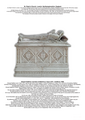
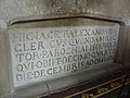
 Chest Tomb Approximately 2 Metres South Of Chancel Of Church Of St Margaret.jpg 4 000 × 2 672; 3,7 MB
-

-
 East Carlton Hall Northamptonshire.jpg 5 184 × 3 456; 7,27 MB
-
 Edward Stafford- 2nd Earl of Wiltshire.png 424 × 600; 214 kB
-
 Entrance to Greatworth Hall - geograph.org.uk - 428786.jpg 640 × 480; 145 kB
-
 Euston-Manchester Pendolino passing Roade.jpg 4 945 × 2 779; 2,48 MB
-
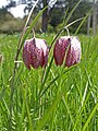 Fritillaries (46760229905).jpg 2 736 × 3 648; 5 MB
-
 Gate on Banbury Lane byway - geograph.org.uk - 815897.jpg 640 × 480; 160 kB
-
 Great Central Railway near Helmdon - geograph.org.uk - 1356258.jpg 640 × 480; 84 kB
-
 Great Central Railway near Helmdon - geograph.org.uk - 1356277.jpg 640 × 480; 93 kB
-
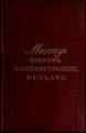 Handbook for travellers in Northamptonshire and Rutland .. (IA handbookfortrave00john 16).pdf 729 × 1 122, 362 páginas; 33,19 MB
-
 Hannington Grange Farm - geograph.org.uk - 1100412.jpg 640 × 480; 42 kB
-
 Hannington Grange Farm entrance - geograph.org.uk - 1100408.jpg 640 × 480; 97 kB
-
 Having Fun - geograph.org.uk - 1164290.jpg 640 × 427; 78 kB
-
 Hazelrigg House.jpg 3 264 × 2 448; 3,09 MB
-
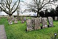 Headstones Greatworth St Peter's churchyard (1).jpg 6 240 × 4 160; 33,71 MB
-
 Headstones Greatworth St Peter's churchyard (2).jpg 5 962 × 3 974; 32,73 MB
-
 Holy Trinity Blatherwycke Northamptonshire England.png 425 × 600; 241 kB
-

-
 It must have been raining^ - geograph.org.uk - 878462.jpg 640 × 428; 69 kB
-
 It's in here somewhere - geograph.org.uk - 1360961.jpg 640 × 425; 191 kB
-

-
 Kelmarsh Hall Northamptonshire England.png 600 × 425; 223 kB
-
 Kelmarsh-Hall Northamptonsh.gif 1 200 × 702; 486 kB
-
 King's Suttom Foot and Mouth notice (3).JPG 1 536 × 1 024; 694 kB
-
 Kirby Hall, Northamptonshire.jpg 1 540 × 1 100; 1,36 MB
-
 Lake, Althorp House - geograph.org.uk - 908601.jpg 640 × 258; 34 kB
-
 Lilbourne Station platform end - geograph.org.uk - 1588688.jpg 640 × 427; 130 kB
-
 Little Preston - geograph.org.uk - 970645.jpg 640 × 480; 116 kB
-
-
 M45 Onley lane - geograph.org.uk - 1671420.jpg 1 600 × 1 200; 363 kB
-
 Mad Apples Cider Bar 2007.jpg 768 × 1 024; 462 kB
-
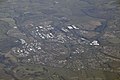 Northamptonshire - Corby Scenery (geograph 5257543).jpg 6 000 × 4 000; 7,53 MB
-
 Northamptonshire Map.png 4 967 × 4 967; 4,23 MB
-
 Old02.JPG 3 648 × 2 736; 1,7 MB
-
 Old03.JPG 3 648 × 2 736; 1,7 MB
-
 Old04.JPG 3 648 × 2 736; 1,71 MB
-
 Old05.JPG 2 736 × 3 648; 1,72 MB
-
 Pastures Farm - geograph.org.uk - 1100417.jpg 640 × 480; 120 kB
-
 Pastures Farm - geograph.org.uk - 1100421.jpg 640 × 480; 62 kB
-
 Pitsford Water, Northamptonshire (28452616514).jpg 4 281 × 1 154; 5,3 MB
-
 Primrose League grand fete and gala advertisement.png 297 × 333; 46 kB
-
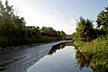
 River Avon and bridge - geograph.org.uk - 1778629.jpg 1 014 × 761; 209 kB
-

-
 Rye Hill Prison - geograph.org.uk - 40460.jpg 614 × 424; 60 kB
-
 Saint Mary the Virgin Great Brington Northamptonshire England.png 600 × 425; 186 kB
-
 Showing the way - geograph.org.uk - 1258781.jpg 427 × 640; 118 kB
-
 Sir John Spencer-1599 Great Brington Northamptonshire.png 425 × 600; 167 kB
-

-
 Spenser arm.png 525 × 600; 590 kB
-
 St Leonard Village of Apethorpe Northamptonshire.png 425 × 600; 222 kB
-
 St Mary and All Saints Fotheringhay Northamptonshire England.png 600 × 425; 249 kB
-
 St Mary's Church Canons Ashby Northamptonshire.png 425 × 600; 213 kB
-
 St Peter and St Paul's Church Weedon Bec.jpg 3 848 × 5 803; 19,99 MB
-
 St Peter's Church Lowick Northamptonshire.png 600 × 424; 246 kB
-
 The Kia Oval - Aug 2011 - My Son's Shy Girlfriend (6012845682).jpg 2 274 × 1 677; 444 kB
-
 The King's England Northamptonshire.jpg 1 027 × 1 449; 366 kB
-
 The last of many - geograph.org.uk - 1071772.jpg 427 × 640; 30 kB
-
 Towards Foxhill Farm - geograph.org.uk - 493989.jpg 640 × 477; 112 kB
-
 Track towards Moreton Pinkney - geograph.org.uk - 493973.jpg 640 × 477; 134 kB
-
 Tree - geograph.org.uk - 1258790.jpg 427 × 640; 110 kB
-
 Tresham College induction 2019.jpg 4 608 × 2 592; 3,69 MB
-
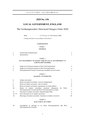 The Northamptonshire (Structural Changes) Order 2020 (UKSI 2020-156 qp).pdf 1 239 × 1 754, 20 páginas; 127 kB
-
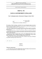 The Northamptonshire (Structural Changes) Order 2020 (UKSI 2020-156).pdf 1 239 × 1 752, 28 páginas; 704 kB
-
 View from Newnham Hill.jpg 4 176 × 2 784; 8 MB
-
 View towards Hothorpe Hall - geograph.org.uk - 547307.jpg 640 × 489; 116 kB
-
 View towards Hothorpe Hills - geograph.org.uk - 547297.jpg 640 × 480; 112 kB
-
 Virgin & Rapeseed - Roade.jpg 5 251 × 3 316; 3,08 MB
-
 Virgin Pendolino & Rapeseed At Roade - II.jpg 5 116 × 3 141; 2,44 MB
-
-
 We won't^ - geograph.org.uk - 878460.jpg 640 × 377; 89 kB
-
 Welford Road towards South Kilworth - geograph.org.uk - 592890.jpg 640 × 480; 136 kB
-
 Willoughby-Great Central Railway - geograph.org.uk - 1033529.jpg 640 × 480; 104 kB
-
 With exposed couplings a Virgin Pendolino from Liverpool heads for London at Roade.jpg 4 926 × 2 076; 1,84 MB
-
 Wittering airfield - geograph.org.uk - 413948.jpg 640 × 480; 92 kB
-
 Abandoned JCB - geograph.org.uk - 428791.jpg 640 × 480; 135 kB
-
 Abandoned rollers beside a sharp bend - geograph.org.uk - 428866.jpg 640 × 480; 132 kB
-
 Airfield in arable land - geograph.org.uk - 234114.jpg 640 × 480; 97 kB
-
 An Edge of Wellingborough Residential Area - geograph.org.uk - 36458.jpg 640 × 480; 103 kB
-
 Bainton footpath - geograph.org.uk - 1513574.jpg 640 × 426; 83 kB
-
 Billing Aquadrome on the Nene - geograph.org.uk - 171699.jpg 640 × 480; 90 kB
-
 Boundary Post - geograph.org.uk - 1461376.jpg 640 × 480; 115 kB
-
 Bridge on Spratton Road - geograph.org.uk - 224534.jpg 640 × 480; 84 kB
-
 Brookside Community Centre - geograph.org.uk - 174644.jpg 640 × 466; 89 kB
-
 Car parking lot, Santa Pod dragstrip - geograph.org.uk - 393102.jpg 640 × 480; 83 kB
-
 Cattle grid - geograph.org.uk - 127143.jpg 640 × 480; 122 kB
-
 Cheshire Railings on a bend in Lutton - geograph.org.uk - 713155.jpg 480 × 640; 109 kB
-

-
 Composting in progress. - geograph.org.uk - 322041.jpg 640 × 480; 103 kB
-
 Cross country jump - geograph.org.uk - 436391.jpg 640 × 480; 132 kB
-
 Danes Moor - geograph.org.uk - 411525.jpg 640 × 428; 101 kB
-
 Derelict House and Farm Buildings - geograph.org.uk - 746100.jpg 640 × 480; 94 kB
-
 Disused building - geograph.org.uk - 327093.jpg 480 × 640; 95 kB
-
 Disused structure - geograph.org.uk - 327085.jpg 640 × 480; 62 kB
-
 Dredging operation - geograph.org.uk - 641114.jpg 640 × 480; 111 kB
-
 Entrance to an Industrial Estate - geograph.org.uk - 174260.jpg 640 × 466; 99 kB
-
 Entrance to Hothorpe Hall - geograph.org.uk - 547311.jpg 640 × 471; 131 kB
-
 Entrance to Lings Forum - geograph.org.uk - 174640.jpg 640 × 480; 109 kB
-
 Everdon - geograph.org.uk - 174358.jpg 640 × 480; 114 kB
-

-
 Fields - geograph.org.uk - 461327.jpg 640 × 480; 115 kB
-
 Frontier Centre - geograph.org.uk - 96868.jpg 640 × 480; 89 kB
-
 Gate Lodge to Ashton Wold House - geograph.org.uk - 378327.jpg 640 × 480; 106 kB
-
 Grazing sheep - geograph.org.uk - 592908.jpg 569 × 640; 158 kB
-
 Grazing sheep at Scoborough - geograph.org.uk - 547379.jpg 640 × 418; 116 kB
-
 Highway Boundary Marker - geograph.org.uk - 779629.jpg 640 × 480; 115 kB
-
 Meadow near Bridleway - geograph.org.uk - 207882.jpg 640 × 480; 101 kB
-
 North Fen - geograph.org.uk - 442790.jpg 640 × 427; 113 kB
-
 North Kilworth - geograph.org.uk - 245269.jpg 640 × 480; 141 kB
-
 Old moat at Ekens' Copse - geograph.org.uk - 378483.jpg 640 × 480; 107 kB
-
 Old roller on footpath to Thenford - geograph.org.uk - 425744.jpg 640 × 480; 99 kB
-
 Paddock at Etton - geograph.org.uk - 442765.jpg 640 × 427; 77 kB
-

-
 Parish Boundary - geograph.org.uk - 111620.jpg 640 × 480; 53 kB
-
 Parish Boundary Hedgerow - geograph.org.uk - 125753.jpg 640 × 480; 102 kB
-
 Recycling facilities - geograph.org.uk - 322048.jpg 640 × 480; 75 kB
-
 Roadside hedge and harvested wheat field - geograph.org.uk - 528736.jpg 640 × 480; 257 kB
-
 Roman Road from Irchester - geograph.org.uk - 404203.jpg 640 × 480; 85 kB
-
 Scrap Vehicles, Danes Moor - geograph.org.uk - 409883.jpg 640 × 428; 102 kB
-
 Seaton Sewage Works - geograph.org.uk - 335401.jpg 640 × 480; 66 kB
-
 Snowbound field-hedge boundary - geograph.org.uk - 335398.jpg 640 × 480; 51 kB
-
 South Kilworth - geograph.org.uk - 150363.jpg 640 × 480; 60 kB
-
 Spring near Slipton Lodge - geograph.org.uk - 378523.jpg 640 × 480; 75 kB
-

-
 Structure from WW2 - geograph.org.uk - 491845.jpg 640 × 480; 100 kB
-

-
 Vauxhall VXR Performance Centre - geograph.org.uk - 428783.jpg 640 × 452; 77 kB
-
 View from the stile - geograph.org.uk - 439171.jpg 640 × 480; 79 kB
-
 View towards a Railway from a Bridleway - geograph.org.uk - 207283.jpg 640 × 480; 126 kB
-
 Weighbridge - geograph.org.uk - 322035.jpg 640 × 480; 87 kB
-
 Wildflowers near Meadow - geograph.org.uk - 207885.jpg 640 × 480; 119 kB


.jpg)


.jpg)


.jpg)
.jpg)


.JPG)


.jpg)


.jpg)


.jpg)