File:Dülmen, Merfeld, Feldweg am Mühlenbach -- 2021 -- 4278-80.jpg
Прејди на прегледникот
Прејди на пребарувањето
Големина на овој преглед: 800 × 533 пиксели. Други разделности: 320 × 213 пиксели | 640 × 427 пиксели | 1.024 × 683 пиксели | 1.280 × 853 пиксели | 2.560 × 1.707 пиксели | 6.703 × 4.469 пиксели.
Изворна податотека (6.703 × 4.469 пиксели, големина: 17,11 МБ, MIME-тип: image/jpeg)
Описи
Описи
Опишете во еден ред што претставува податотекава
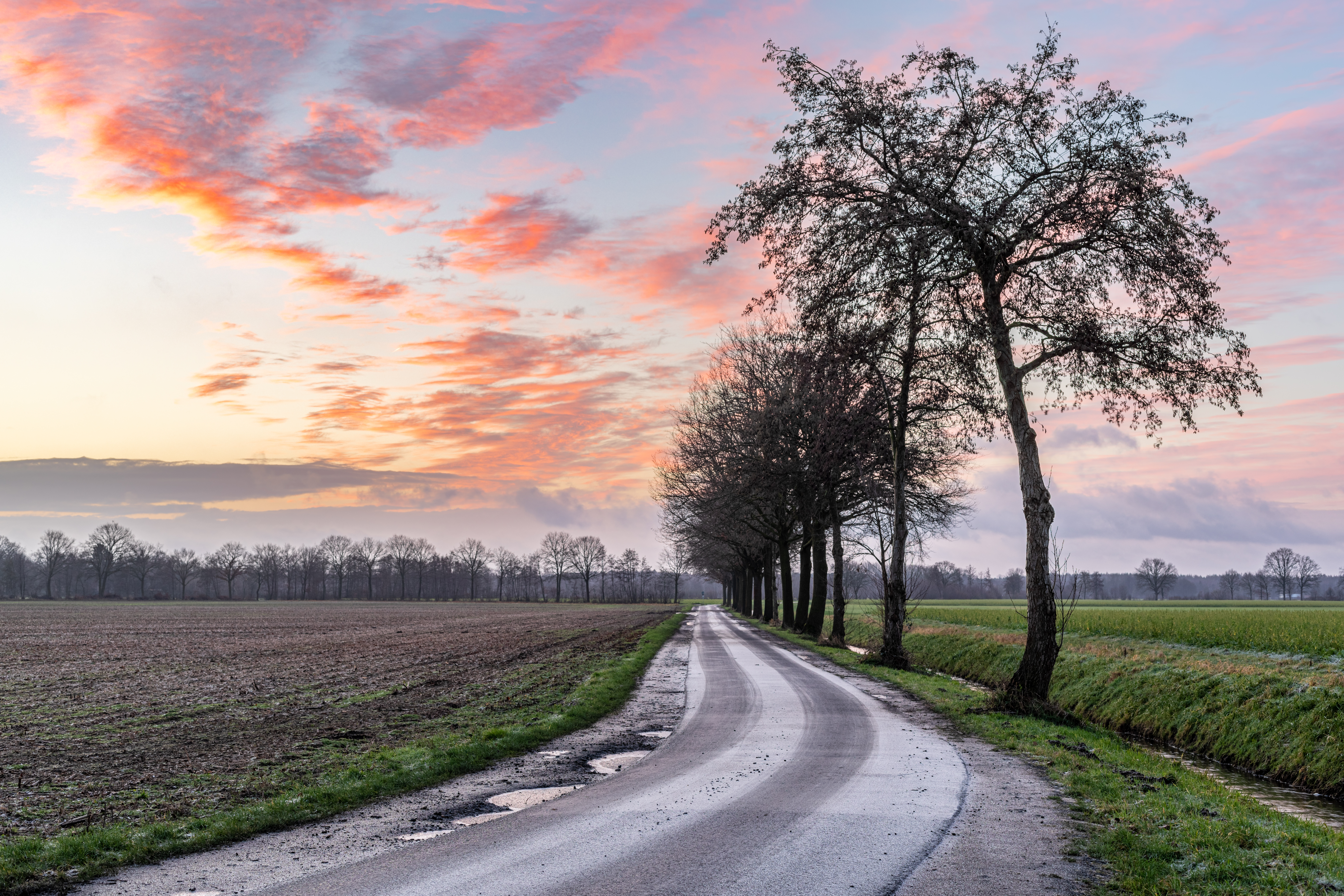
Farm road at Mühlenbach in the hamlet in Merfeld, Dülmen, North Rhine-Westphalia, Germany (2021)
Опис
[уреди]| Опис |
Deutsch: Wirtschaftsweg am Mühlenbach in der Bauerschaft in Merfeld, Dülmen, Nordrhein-Westfalen, Deutschland
Dansk: Gårdsvej langs Mühlenbach i Bauerschaft i Merfeld, Dülmen, Nordrhein-Westfalen, Tyskland
Ελληνικά: Αγροτικός δρόμος κατά μήκος του Mühlenbach στο Bauerschaft στο Merfeld, Dülmen, Βόρεια Ρηνανία-Βεστφαλία, Γερμανία
Español: Carretera agrícola helada y arroyo con árboles cerca de Merfeld en Dülmen, Renania del Norte-Westfalia, Alemania
Français : Chemin d’exploitation au Mühlenbach dans la Bauerschaft à Merfeld, Dülmen, Rhénanie-du-Nord-Westphalie, Allemagne
Italiano: Sentiero agricolo lungo il Mühlenbach nella Bauerschaft di Merfeld, Dülmen, Renania Settentrionale-Vestfalia, Germania
Lietuvių: Ūkio kelias palei Mühlenbach upę Bauerschaft in Merfeld, Dülmen, Šiaurės Reinas-Vestfalija, Vokietija
Nederlands: Boerderijpad langs de Mühlenbach in de Bauerschaft in Merfeld, Dülmen, Noordrijn-Westfalen, Duitsland
Polski: Droga rolnicza wzdłuż rzeki Mühlenbach w gminie Bauerschaft w Merfeld, Dülmen, Nadrenia Północna-Westfalia, Niemcy
Русский: Сельскохозяйственная дорога у ручья Мюленбах фермерского сообщества в Мерфельде, Дюльмен, Северный Рейн-Вестфалия, Германия (2021 г.)
Slovenščina: Kmečka pot ob reki Mühlenbach na območju Bauerschaft in Merfeld, Dülmen, Severno Porenje-Vestfalija, Nemčija
Türkçe: Merfeld, Dülmen, Kuzey Ren-Vestfalya, Almanya’daki Bauerschaft’ta Mühlenbach boyunca uzanan çiftlik yolu
|
||||||||||||||||||||||||||||||||
| Место | |||||||||||||||||||||||||||||||||
| Прикажува | farm road – service road that serves predominantly agricultural or forestry purposes and has only local significance | ||||||||||||||||||||||||||||||||
| Технички одредби |
|
||||||||||||||||||||||||||||||||
| Податоци за сликата |
|
||||||||||||||||||||||||||||||||
| Датум | Направена на 13 јануари 2021, 08:20 | ||||||||||||||||||||||||||||||||
| Извор | сопствено дело | ||||||||||||||||||||||||||||||||
| Автор |
|
||||||||||||||||||||||||||||||||
| Дозвола (Повторно користење на податотекава) |
 .svg) I. Licence
This photograph is protected by copyright law. However, it may be used for free by anyone, provided it is used in accordance with the license Creative Commons License “Attribution-ShareAlike 4.0 International” (CC BY-SA 4.0). These include, among other things, the naming of the author and the license, as well as the setting of a link to the license text or its complete imprint. The attribution should be done as follows:
Please read the text of the license carefully before using the photograph. If you do not agree with the conditions of the license or if you do not understand these conditions, please refrain from using the photo. If you have any questions regarding the license or the reuse of the image, please contact me before using it. If you do not comply with the terms of the license, you do not acquire any right to use the image. If you need another license to use, please contact the author before using.
For informations about the licence see section Лиценцирање or as human-readable summary or as full licence text at Creative Commons. In addition to the above, a link to the source - so this page with the descriptions and license terms - is appreciated. More information or examples of use can be found at re-use (with example file). The Attribution Generator is helpful in licensing matters.
As an alternative to the Creative Commons License CC BY-SA 4.0, the Free Art License (from version 1.3) may also be used.
II. Fairness
From printed materials and other tangible products that use that work, the user is asked to send a copy to the author as thank you. However, this is not a condition for the use of the photo, but a voluntary service. The mailing address can be requested via the contact options.
Please note that the author had quite considerable effort to draw up this file. Thus, it is only fair to comply with the conditions of free licenses listed here. In the case of violation of the license conditions, the rights granted hereunder will expire automatically.
III. Disclaimer
Please note that the license applies solely for the reuse of the photograph itself. The license doesn't grant you any right regarding the depicted object (eg, copyright or proprietary rights) or the personality rights of the person eventually shown. (See licences and non-copyright restrictions.) I do not grant any warranty that the subsequent use of the photograph is legally possible concerning the object or person shown in the photograph. You are responsible to check and respect these rights in the publication in the respective medium or country.
The author is not responsible for the accuracy of the information contained herein (description, title, etc.). Likewise, the author assumes no liability for further use. Please note the general disclaimer and please read reusing content outside Wikimedia too.
IV. Contact
|
||||||||||||||||||||||||||||||||
| Припис (по налог на лиценцата) | Dietmar Rabich / Wikimedia Commons / /
|
||||||||||||||||||||||||||||||||
| Кратка URL | https://w.wiki/9AwE, https://w.wiki/_ts6o (Shortlink) |
||||||||||||||||||||||||||||||||
| Keywords | Acker, Available light, Bach, Bauerschaft, Baum, Bäume und Wälder, Bild des Tages, Blau, Blue, Bodies of water, Contre-jour, Contre-jour photography, Dämmerung, Deutschland, Dülmen, Eins, Eis, Exzellentes Bild, Featured picture, Feld, Felder und Wiesen, Field, Flora, Fluss, Forest, Fotokunst, Gegenlicht, Geographie, Germany, Gewässer, Green, Grün, HDR, HDRI, HDR-Image, HDR image, High Dynamic Range Image, Kreis Coesfeld, Landscape, Landscape photography, Landschaft, Landschaftsfotografie, Landwirtschaft, Licht und Schatten, Meadow, Merfeld, Möbel, Morgen, Münsterland, Natur, Nordrhein-Westfalen, North Rhine-Westphalia, Object, Objekt, One, Orange, Pflanze, Picture of the day, Plant, Pond, Qualitätsbild, Quality image, River, Road, Schutzgebiet, Sonne, Sonnenaufgang, Stadtmöbel, Straße, Straßenmöbel, Straßen und Wege, Stream, Street, Sunrise, Teich, Tone-mapped HDR image, Transport, Tree, Tree photography, Verkehr, Wald, Wasser, Westfalen, Wetter, Wiese, Winter, Wirtschaftsweg, Wolke, 1, 2021 | ||||||||||||||||||||||||||||||||


| Местопол. на апаратот | | Оваа и други слики и нивните местоположби на: OpenStreetMap |
|---|
| НАПОМЕНА: Оваа слика е сочинета од барем три поединечни слики, здружени во слика со висок динамички опсег (HDRI) по пат на тонско пресликување (или како изложно соединение, наречено псевдо-HDRI), што значи дека биле дигитално обработени. Затоа, сликава може да не биде точен одраз на стварноста во секоја поединост. |
Оценка
[уреди]
|
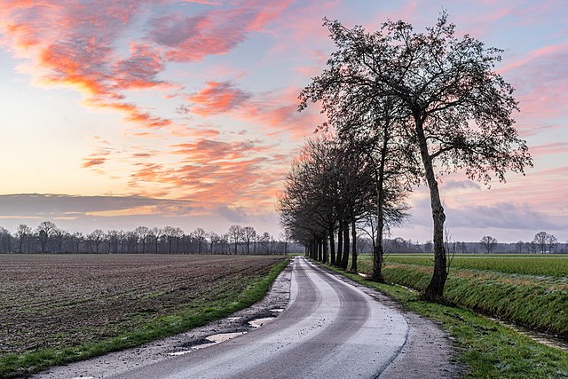
Сликава е избрана за слика на денот за 2 ноември 2022 г. Нејзиниот опис гласи: Други јазици:
Čeština: Zledovatělá cesta k farmě u německé vesnice Merfeld a města Dülmen ve spolkové zemi Severní Porýní-Vestfálsko za východu slunce. Deutsch: Eisbedeckter Wirtschaftsweg bei Sonnenaufgang nahe Merfeld in Dülmen, Nordrhein-Westfalen, Deutschland Español: Camino agrícola cubierto de hielo, cerca de Merfeld, Dülmen, Renania del Norte-Westfalia, Alemania. Français : Lever de soleil hivernal près de Dülmen (Allemagne). Magyar: Jeges mezőgazdasági út napfelkeltekor Merfeld közelében (Dülmen, Észak-Rajna-Vesztfália, Németország) Português: Estrada rural coberta de gelo ao nascer do sol perto de Merfeld, Dülmen, Renânia do Norte-Vestefália, Alemanha. Українська: Покрита льодом польова дорога на світанку поблизу Мерфельда, Дюльмен, Північний Рейн-Вестфалія, Німеччина. 日本語: ドイツにあるノルトライン・ヴェストファーレン州の日の出に照らされる氷に覆われた農道 |
Лиценцирање
[уреди]Dietmar Rabich, праводржецот на ова дело, со ова го објавувам истото под следнава лиценца:
Оваа податотека е под лиценцата Криејтив комонс Наведи извор-Сподели под исти услови 4.0 Меѓународна.
Припис: Dietmar Rabich
- Можете:
- да споделите – да го умножувате, распространувате и емитувате делото
- да преработувате – да преработувате
- Под следните услови:
- наведи извор – Ќе мора да дадете прикладен припис, да ставите врска до лиценцата и да укажете дали има направено промени. Ова може да биде направено на било кој разумен начин, но без да оддава впечаток дека лиценцодавецот стои зад Вас и Вашата употреба.
- сподели под исти услови – Ако го измените или преобразите делото, или пак ако основате друго дело на него, добиеното дело (придонесот) морате да го распространувате (објавувате) само под истата или складна лиценца на изворната.
Notes
Photographs
|
You like this photograph? That pleases me very much! You would like to see more of my pictures? With pleasure.
Wikimedia Commons has a large number of my photographs available under a free license. This makes it easy for you and me. The license details are for each picture. The use is easier than you think, because in essence, this is just the attribution in the form I want. In addition, usage notes are listed for each picture. And if it does not fit, just ask. My contact information is also available with every photograph. |


Историја на податотеката
Стиснете на датум/време за да ја видите податотеката како изгледала тогаш.
| Датум/време | Минијатура | Димензии | Корисник | Коментар | |
|---|---|---|---|---|---|
| тековна | 13:43, 13 јануари 2021 | | 6.703 × 4.469 (17,11 МБ) | XRay (разговор | придонеси) | rm dust spot |
| 12:43, 13 јануари 2021 |  | 6.703 × 4.469 (17,11 МБ) | XRay (разговор | придонеси) | Uploaded with LrMediaWiki 0.8.0, LR 10.1.1 Mac |
Не можете да презапишете врз податотекава.
Употреба на податотеката
Податотекава се користи во повеќе од 100 страници. Следниов список ги прикажува само првите 100 страници што ја користат податотеката. Целосен список ќе најдете тука.
- Photographs by Dietmar Rabich/Top 12
- Puddle
- User:Andrew J.Kurbiko/POTD/2022
- User:Kacamata/Favorites
- User:Meiræ/21
- User:XRay/Favorites
- User:XRay/Featured pictures
- User:XRay/Queries/Commons categories
- User:XRay/Queries/Dülmen
- User:XRay/Results/5
- User:XRay/Statistics
- User:XRay/Statistics/Highlighted content
- User:XRay/Statistics/Pictures of the Day
- User:XRay/Temp
- User talk:XRay/Archive/2021
- Commons:Featured picture candidates/File:Dülmen, Merfeld, Feldweg am Mühlenbach -- 2021 -- 4278-80.jpg
- Commons:Featured picture candidates/Log/February 2021
- Commons:Featured pictures/Places/Agriculture
- Commons:Featured pictures/chronological/2021-A
- Commons:Featured pictures/chronological/February 2021
- Commons:Quality images/Subject/Architecture/Transport Infrastructure/Other
- Commons:Quality images candidates/Archives February 06 2021
- File:Blue Mountains National Park (AU), Jamison Valley -- 2019 -- 2016.jpg
- File:Blue Mountains National Park (AU), Three Sisters -- 2019 -- 1946.jpg
- File:Blue Mountains National Park (AU), Three Sisters -- 2019 -- 1983.jpg
- File:Blue Mountains National Park (AU), Three Sisters -- 2019 -- 1987-9.jpg
- File:Blue Mountains National Park (AU), Three Sisters -- 2019 -- 2009.jpg
- File:Dülmen, Börnste, Fischteiche, Schilfgras -- 2020 -- 0198.jpg
- File:Dülmen, Hausdülmen, Wallgarten -- 2015 -- 0221.jpg
- File:Dülmen, Hausdülmen, Wallgarten -- 2015 -- 0223-7-2.jpg
- File:Dülmen, Hausdülmen, Wallgarten -- 2015 -- 0228-32.jpg
- File:Dülmen, Kirchspiel, Börnste, Baumgruppe -- 2022 -- 9880-4.jpg
- File:Dülmen, Kirchspiel, Börnste, Feldweg -- 2017 -- 3180-6.jpg
- File:Dülmen, Kirchspiel, Börnste, Neusträßer Graben -- 2021 -- 4893.jpg
- File:Dülmen, Kirchspiel, Börnste, Neusträßer Graben -- 2021 -- 4894.jpg
- File:Dülmen, Kirchspiel, Börnste -- 2016 -- 5646.jpg
- File:Dülmen, Kirchspiel, Feld am Strandbadweg -- 2016 -- 5654.jpg
- File:Dülmen, Kirchspiel, Heubach -- 2021 -- 0522.jpg
- File:Dülmen, Kirchspiel, NSG Franzosenbach -- 2016 -- 1805-11.jpg
- File:Dülmen, Kirchspiel, NSG Franzosenbach -- 2016 -- 1812-8.jpg
- File:Dülmen, Kirchspiel, NSG Franzosenbach -- 2016 -- 1819-25.jpg
- File:Dülmen, Kirchspiel, NSG Karthäuser Mühlenbach -- 2016 -- 2683.jpg
- File:Dülmen, Kirchspiel, NSG Karthäuser Mühlenbach -- 2016 -- 4698.jpg
- File:Dülmen, Kirchspiel, NSG Welter Bach -- 2016 -- 1827.jpg
- File:Dülmen, Kirchspiel, NSG Welter Bach -- 2016 -- 1834.jpg
- File:Dülmen, Kirchspiel, Wiese in der Bauerschaft Börnste -- 2016 -- 1488-94 - bw.jpg
- File:Dülmen, Kirchspiel, Wiese in der Bauerschaft Börnste -- 2016 -- 1516-22.jpg
- File:Dülmen, Kläranlage -- 2014 -- 4361.jpg
- File:Dülmen, Naturschutzgebiet -Am Enteborn- -- 2014 -- 0187.jpg
- File:Dülmen, Naturschutzgebiet -Am Enteborn- -- 2014 -- 0189.jpg
- File:Dülmen, Naturschutzgebiet -Am Enteborn- -- 2014 -- 0191.jpg
- File:Dülmen, Naturschutzgebiet -Am Enteborn- -- 2014 -- 0192.jpg
- File:Dülmen, Naturschutzgebiet -Am Enteborn- -- 2014 -- 0193.jpg
- File:Dülmen, Naturschutzgebiet -Am Enteborn- -- 2014 -- 0196.jpg
- File:Dülmen, Naturschutzgebiet -Am Enteborn- -- 2014 -- 0197.jpg
- File:Dülmen, Naturschutzgebiet -Franzosenbach-, Strotbach -- 2014 -- 0029.jpg
- File:Dülmen, Naturschutzgebiet -Franzosenbach- -- 2014 -- 0048.jpg
- File:Dülmen, Naturschutzgebiet -Welter Bach- -- 2014 -- 0008.jpg
- File:Dülmen, Naturschutzgebiet -Welter Bach- -- 2014 -- 0009.jpg
- File:Dülmen, Naturschutzgebiet -Welter Bach- -- 2014 -- 0010.jpg
- File:Dülmen, Wiese am Kapellenweg -- 2014 -- 8085.jpg
- File:Dülmen, Wiese am Strandbadweg -- 2016 -- 5684-90.jpg
- File:Haltern am See, Silbersee III -- 2014 -- 5897.jpg
- File:Haltern am See, Silbersee III -- 2014 -- 5898.jpg
- File:Haltern am See, Silbersee III -- 2014 -- 5900.jpg
- File:Haltern am See, Silbersee III -- 2014 -- 5903.jpg
- File:Haltern am See, Silbersee III -- 2017 -- 0276.jpg
- File:Haltern am See, Silbersee III -- 2017 -- 0279.jpg
- File:Haltern am See, Silbersee III -- 2017 -- 0280.jpg
- File:Haltern am See, Silbersee IV -- 2014 -- 5905.jpg
- File:Joshua Tree National Park (California, USA) -- 2012 -- 5663 (crop).jpg
- File:Kakadu (AU), Kakadu National Park, Jim Jim Creek -- 2019 -- 4248.jpg
- File:Kakadu (AU), Kakadu National Park, Nadap Lookout -- 2019 -- 4182.jpg
- File:Kakadu (AU), Kakadu National Park, Nadap Lookout -- 2019 -- 4190.jpg
- File:Kakadu (AU), Kakadu National Park, Nadap Lookout -- 2019 -- 4200.jpg
- File:Kakadu (AU), Kakadu National Park, Nadap Lookout -- 2019 -- 4201.jpg
- File:Lüdinghausen, Borkenberge -- 2014 -- 7833.jpg
- File:Norderney, Nordsee am Oststrand -- 2016 -- 5167 (bw).jpg
- File:Norderney, Weststrand -- 2018 -- 1089.jpg
- File:Norderney, Weststrand -- 2018 -- 1098.jpg
- File:Norderney, Weststrand -- 2018 -- 1104.jpg
- File:Norderney, Weststrand -- 2018 -- 1106.jpg
- File:Norderney, Weststrand -- 2018 -- 1110.jpg
- File:Norderney, Weststrand -- 2018 -- 1113.jpg
- File:Norderney, Weststrand -- 2018 -- 1114.jpg
- File:Nordkirchen, Naturschutzgebiet Ichterloh -- 2018 -- 2114-8.jpg
- File:Nottuln, Stevertal, Feld -- 2017 -- 0701.jpg
- File:Nottuln, Stevertal, Feld -- 2017 -- 0712.jpg
- File:Nottuln, Stevertal, Wiese -- 2017 -- 0698.jpg
- File:Osterholz-Scharmbeck, Naturschutzgebiet "Breites Wasser" -- 2018 -- 3021.jpg
- File:Osterholz-Scharmbeck, Naturschutzgebiet "Breites Wasser" -- 2018 -- 3023.jpg
- File:Osterholz-Scharmbeck, Naturschutzgebiet "Breites Wasser" -- 2018 -- 3024.jpg
- File:Osterholz-Scharmbeck, Naturschutzgebiet "Breites Wasser" -- 2018 -- 3026.jpg
- File:Osterholz-Scharmbeck, Naturschutzgebiet "Breites Wasser" -- 2018 -- 3028.jpg
- File:Rosendahl, Holtwick, Barenborg -- 2014 -- 2308.jpg
- File:Santorin (GR), Exomytis, Vlychada Beach -- 2017 -- 2999 (bw) - 2.jpg
- File:Senden, Bösensell, Bauerschaft Kley -- 2014 -- 7399.jpg
- Template:Potd/2022-11
- Template:Potd/2022-11-02
- Template:Potd/2022-11-02 (de)
,_Jamison_Valley_--_2019_--_2016.jpg)
,_Three_Sisters_--_2019_--_1946.jpg)
,_Three_Sisters_--_2019_--_1983.jpg)
,_Three_Sisters_--_2019_--_1987-9.jpg)
,_Three_Sisters_--_2019_--_2009.jpg)
_--_2012_--_5663_(crop).jpg)
,_Kakadu_National_Park,_Jim_Jim_Creek_--_2019_--_4248.jpg)
,_Kakadu_National_Park,_Nadap_Lookout_--_2019_--_4182.jpg)
,_Kakadu_National_Park,_Nadap_Lookout_--_2019_--_4190.jpg)
,_Kakadu_National_Park,_Nadap_Lookout_--_2019_--_4200.jpg)
,_Kakadu_National_Park,_Nadap_Lookout_--_2019_--_4201.jpg)
.jpg)
,_Exomytis,_Vlychada_Beach_--_2017_--_2999_(bw)_-_2.jpg)
Погледајте ги останатите врски кон оваа податотека.
Глобална употреба на податотеката
Оваа податотека ја користат и следниве викија:
- Употреба на alt.wikipedia.org
- Употреба на av.wikipedia.org
- Употреба на cv.wikipedia.org
- Употреба на de.wikipedia.org
- Употреба на hu.wikipedia.org
- Употреба на it.wiktionary.org
- Употреба на kk.wikipedia.org
- Употреба на ko.wikipedia.org
- Употреба на lbe.wikipedia.org
- Употреба на lez.wikipedia.org
- Употреба на mk.wikipedia.org
- Употреба на os.wikipedia.org
- Употреба на pt.wikipedia.org
- Употреба на ru.wikipedia.org
- Употреба на sah.wikipedia.org
- Употреба на uk.wikipedia.org
- Употреба на uz.wikipedia.org
- Употреба на vep.wikipedia.org
- Употреба на www.wikidata.org
- Употреба на zh.wikipedia.org
Метаподатоци
Категории:
- Landschaftsschutzgebiet Merfeld-Süd
- Fields in Merfeld
- Trees in Merfeld
- Bare trees in Dülmen
- Landscapes of Dülmen
- Streams in Dülmen
- Frozen puddles in North Rhine-Westphalia
- Street trees in North Rhine-Westphalia
- Channelised rivers and streams in Germany
- Trees and sky in Germany
- Trees at sunrise in Germany
- Icy roads in Germany
- Curves (road) in North Rhine-Westphalia
- Rural ways in Merfeld
- Single track roads in Germany
- Empty streets in North Rhine-Westphalia
- Views from roads in North Rhine-Westphalia
- Sunrises in 2021
- Sunrises of Dülmen
- Dawn in Kreis Coesfeld
- Blue and green landscapes
- Clouds and blue sky in Merfeld
- Clouds at sunrise in Germany
- Orange clouds in North Rhine-Westphalia
- Contre-jour photographs of landscapes
- Contre-jour photographs of rivers
- Contre-jour photography of Germany
- Winter landscapes in North Rhine-Westphalia
- Winter 2020-2021 in Dülmen
- Trees in winter 2020-2021 in North Rhine-Westphalia
- Fields in Kreis Coesfeld in January
- Trees in North Rhine-Westphalia in January
- Foreglow in Germany